Dreiherrenstein

Log in to your account

AroundUs is a community-driven map of interesting places, built by curious explorers like you. It grows with every review, story, and photo you share.
Connect to save your favorite spots, contribute locations, and create personalized routes.
Continue with Google
Continue with Apple
Continue with X
Continue with Facebook
Continue with email
By continuing, you accept our Terms and Conditions and our Privacy Policy
Create an account
Add to collection
Map
Suggest a change
Share

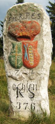
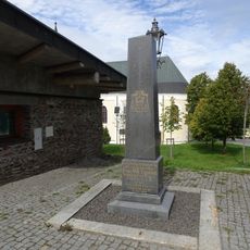
Dreiherrenstein, Boundary marker in Ore Mountains, Germany.

Dreiherrenstein is a triangular boundary stone in the Ore Mountains with coats of arms carved into its surfaces that mark different territories. The stone's design documents the borders that divided several power domains across this mountain region.

The stone was erected in 1677 as a boundary marker between several ruling powers of this mountain region. It was reworked in 1729 to refresh the markings and keep the borders clearly visible.

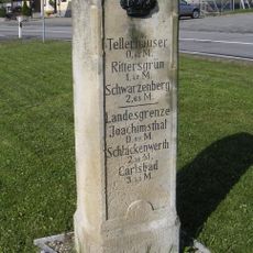
The stone displays carved coats of arms that marked the territories of the ruling powers in this border region. Visitors can still see these symbols today and understand how important such markers were for organizing the land in earlier times.

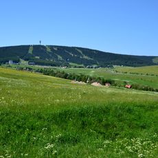
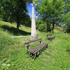
The stone sits in a mountain landscape and is reachable from the road, though a short walk across the terrain is needed. Visitors should wear weather-resistant clothing and sturdy footwear, since the high elevation and rough mountain terrain can bring harsh conditions.

The stone was carved by a stonecutter from Sankt Joachimsthal, whose craftsmanship is visible in the inscriptions. This local connection to the mining region is reflected in the careful execution of the coat of arms designs.

Location: Oberwiesenthal

Location: Jáchymov

Location: Loučná pod Klínovcem

Inception: 1677

Part of: Czech Republic–Germany border

GPS coordinates: 50.40472,12.94817

Latest update: December 9, 2025 12:23

Photos
Around this place
Klínovec
Czech Republic

Klínovec

1.7 km
Klínovec (rozhledna)
Czech Republic

Klínovec (rozhledna)

1.7 km
Town hall in Boží Dar
Czech Republic

Town hall in Boží Dar

1.9 km
Horský hotel a rozhledna na Klínovci
Czech Republic

Horský hotel a rozhledna na Klínovci

1.7 km
Hotel Praha
Czech Republic

Hotel Praha

1.7 km
Church of Saint Anne in Boží Dar
Czech Republic

Church of Saint Anne in Boží Dar

1.8 km
Neues Haus
Germany

Neues Haus

1.2 km
Jáchymovská hornatina
Czech Republic

Jáchymovská hornatina

1.2 km
Historical petrol pump in Boží Dar
Czech Republic

Historical petrol pump in Boží Dar

1.5 km
Fichtelberg
Germany

Fichtelberg

1.5 km
Muzeum Boží Dar
Czech Republic

Muzeum Boží Dar

1.9 km
Statue of John of Nepomuk in Boží Dar
Czech Republic

Statue of John of Nepomuk in Boží Dar

1.8 km
Pomník nejvyššího bodu Ústeckého kraje na Klínovci
Czech Republic

Pomník nejvyššího bodu Ústeckého kraje na Klínovci

1.8 km
Fichtelberg
Germany

Fichtelberg

2.2 km
Památník Franze Tippmanna v Božím Daru
Czech Republic

Památník Franze Tippmanna v Božím Daru

1.7 km
Kleiner Fichtelberg
Germany

Kleiner Fichtelberg

2 km
Royal Saxon milestone in Oberwiesenthal
Germany

Royal Saxon milestone in Oberwiesenthal

1.1 km
Polish-Saxon Post Milestone in Oberwiesenthal Zechengrund
Germany

Polish-Saxon Post Milestone in Oberwiesenthal Zechengrund

1.3 km
Pamětní kříž u kostela v Božím Daru
Czech Republic

Pamětní kříž u kostela v Božím Daru

1.8 km
Pomník padlým na náměstí v Božím Daru
Czech Republic

Pomník padlým na náměstí v Božím Daru

2 km
Kašna v západní části náměstí v Božím Daru
Czech Republic

Kašna v západní části náměstí v Božím Daru

2 km
Fichtelbergwiesen
Germany

Fichtelbergwiesen

1.3 km
Wohnhaus (ursprünglich Gießerei) in halboffener Bebauung Böhmische Straße 8
Germany

Wohnhaus (ursprünglich Gießerei) in halboffener Bebauung Böhmische Straße 8

2.2 km
Polish-Saxon Post Milestone in Oberwiesenthal
Germany

Polish-Saxon Post Milestone in Oberwiesenthal

2.3 km
Grenzbrücke über die Polava bei Oberwiesenthal
Czech Republic

Grenzbrücke über die Polava bei Oberwiesenthal

1.6 km
Kašna ve východní části náměstí v Božím Daru
Czech Republic

Kašna ve východní části náměstí v Božím Daru

2 km
Hotelgebäude in offener Bebauung und Ecklage Markt 15
Germany

Hotelgebäude in offener Bebauung und Ecklage Markt 15

2.2 km
Stadtbeleuchtung Markt -
Germany

Stadtbeleuchtung Markt -

2.3 km
Show the full map
Reviews

Visited this place? Tap the stars to rate it and share your experience / photos with the community! Try now! You can cancel it anytime.

« Dreiherrenstein - Boundary marker in Ore Mountains, Germany » is provided by Around Us (aroundus.com). Images and texts are derived from Wikimedia project under a Creative Commons license. You are allowed to copy, distribute, and modify copies of this page, under the conditions set by the license, as long as this note is clearly visible.

Discover hidden gems everywhere you go!

From secret cafés to breathtaking viewpoints, skip the crowded tourist spots and find places that match your style. Our app makes it easy with voice search, smart filtering, route optimization, and insider tips from travelers worldwide. Download now for the complete mobile experience.

Around Us App Screenshot

A unique approach to discovering new places

Le Figaro

All the places worth exploring

France Info

A tailor-made excursion in just a few clicks

20 Minutes