Enable Location

We need your location to show you interesting places around you

Discover nearby places

Find interesting locations and hidden gems around you

Precise directions

Get accurate directions and distances to places

Your location is never shared with other users. It's only used when you tap the location button.

Chretien Point Plantation

Log in to your account

Start exploring — it's free

Trusted by 62,490 travelers worldwide

Continue with Google
Continue with Apple
or

We will send you a code to connect

By continuing, you accept our Terms and Conditions and our Privacy Policy

Check your inbox

We've sent a pincode in your inbox. Please enter the code below.

Chretien Point Plantation, human settlement in St. Landry Parish, Louisiana, United States of America

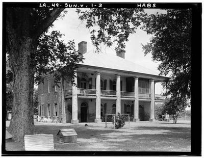
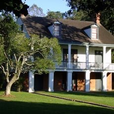
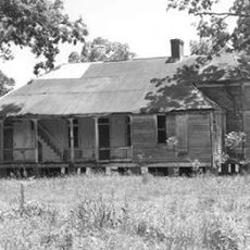
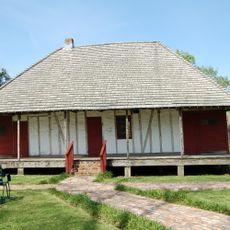
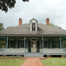
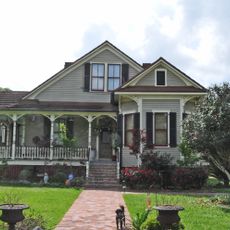
Chretien Point Plantation is a two-story brick building from the 1830s featuring rounded arches on windows and doors along the galleries. The house contains twelve rooms, wide porches, and was designed following a Creole plan with three rooms across the front and a loggia with stairs at the back.

The land was granted by Spain in 1776 and purchased by Joseph Chrétien in 1781, whose grandson Hypolite began construction in 1831 and moved in by 1835. During the Civil War, the Battle of Buzzard's Prairie took place on the grounds in 1863, but the house was spared when the owner displayed a Masonic sign revealing brotherhood with a Union commander.

The name comes from the Chrétien family who owned and shaped the land for generations. The wife of the original builder was known for hosting card games and social gatherings that defined the social life of the plantation during its active years.

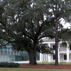
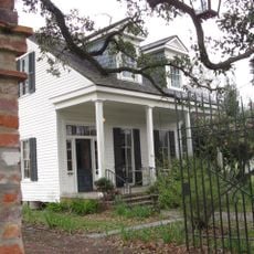
The property is located about 2 miles (3 kilometers) southwest of Sunset in St. Landry Parish and offers tours, weddings, and overnight stays in the restored house. Visitors can walk through the old building and explore the fields where cotton was once grown while taking in the landscape that has changed little since the 1800s.

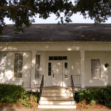
The famous pirate Jean Lafitte reportedly lived on the plantation for some time and taught the owner's wife how to smoke cigars. The house has changed little in over 180 years, and many speak of strange noises and lights that keep local folklore alive.

The community of curious travelers

AroundUs brings together thousands of curated places, local tips, and hidden gems, enriched daily by 60,000 contributors worldwide.

Start exploring
GPS coordinates
30.38833,-92.10222
Latest update
February 7, 2026 11:00
Around this place
Cajundome
United States of America

Cajundome

19.9 km
Cajun Field
United States of America

Cajun Field

20.1 km
Cathedral of Saint John the Evangelist
United States of America

Cathedral of Saint John the Evangelist

19.9 km
St. Landry Catholic Church
United States of America

St. Landry Catholic Church

17.3 km
Paul and Lulu Hilliard University Art Museum
United States of America

Paul and Lulu Hilliard University Art Museum

21.6 km
Alexandre Mouton House
United States of America

Alexandre Mouton House

20.2 km
Planet Ice Skating and Hockey Arena
United States of America

Planet Ice Skating and Hockey Arena

22.1 km
Vermilionville Historic Village
United States of America

Vermilionville Historic Village

21.9 km
Charles H. Mouton House
United States of America

Charles H. Mouton House

19.5 km
Martin Donato House
United States of America

Martin Donato House

18.7 km
Freetown-Port Rico Historic District
United States of America

Freetown-Port Rico Historic District

20.7 km
Brandt House
United States of America

Brandt House

19.4 km
Joseph D. Bernard House
United States of America

Joseph D. Bernard House

22.5 km
Venus House
United States of America

Venus House

16.1 km
Old Lafayette City Hall
United States of America

Old Lafayette City Hall

20.1 km
Hope Lodge No. 145
United States of America

Hope Lodge No. 145

20 km
Edward Benjamin Dubuisson House
United States of America

Edward Benjamin Dubuisson House

16.7 km
Elrose
United States of America

Elrose

20.5 km
Bank of Scott
United States of America

Bank of Scott

17 km
Le Vieux Presbytere
United States of America

Le Vieux Presbytere

11.1 km
Patin House
United States of America

Patin House

23.3 km
Dr. Joseph Angel Villien House
United States of America

Dr. Joseph Angel Villien House

31.5 km
Acadiana Center for the Arts
United States of America

Acadiana Center for the Arts

20 km
Acadian Cultural Center
United States of America

Acadian Cultural Center

22.1 km
Rice Theatre
United States of America

Rice Theatre

32.6 km
Liberty Center for the Performing Arts
United States of America

Liberty Center for the Performing Arts

32.2 km
Moundville Plantation
United States of America

Moundville Plantation

28.6 km
Bayou Teche LA 3361 Bridge
United States of America

Bayou Teche LA 3361 Bridge

23.3 km
Show the full map
« Chretien Point Plantation - human settlement in St. Landry Parish, Louisiana, United States of America » is provided by Around Us (aroundus.com). Images and texts are derived from Wikimedia project under a Creative Commons license. You are allowed to copy, distribute, and modify copies of this page, under the conditions set by the license, as long as this note is clearly visible.

Discover hidden gems everywhere you go!

From secret cafés to breathtaking viewpoints, skip the crowded tourist spots and find places that match your style. Our app makes it easy with voice search, smart filtering, route optimization, and insider tips from travelers worldwide. Download now for the complete mobile experience.

Around Us App Screenshot

A unique approach to discovering new places

Le Figaro

All the places worth exploring

France Info

A tailor-made excursion in just a few clicks

20 Minutes

Around Us
Travel Guide & Maps
Download

Send to your phone

QR Code
1

Open the camera app on your mobile.

2

Point at the QR code with your camera. A notification will appear.

3

Tap the notification to open the link.