Enable Location

We need your location to show you interesting places around you

Discover nearby places

Find interesting locations and hidden gems around you

Precise directions

Get accurate directions and distances to places

Your location is never shared with other users. It's only used when you tap the location button.

Log in to your account

Start exploring — it's free

Trusted by 64,523 travelers worldwide

Continue with Google
Continue with Apple
or

We will send you a code to connect

By continuing, you accept our Terms and Conditions and our Privacy Policy

Check your inbox

We've sent a pincode in your inbox. Please enter the code below.

Palo Pinto Mountains State Park
Discussion Reviews Photo
3.6k Popularity

Palo Pinto Mountains State Park, State park in Palo Pinto County, Texas.

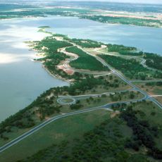
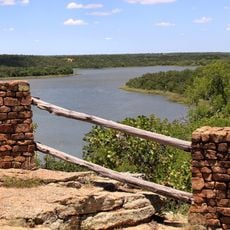
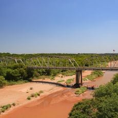
Palo Pinto Mountains State Park is a Texas state park in Palo Pinto County featuring high plateaus, canyons, and a lake at its center. The terrain belongs to the Cross Timbers forest region, where rocky ridges and open woodland cover the hills and drop into narrow valleys.

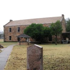
Before becoming a park, the land was used as a working ranch for many decades and before that was home to Indigenous peoples for thousands of years. The Texas Parks and Wildlife Department bought the property in 2010 with help from the Texas Nature Conservancy.

The name "Palo Pinto" comes from Spanish and refers to the painted or spotted wood of the trees found in the area. Walking through the park today, visitors notice that this mix of rocky terrain and patchy woodland still matches that old description closely.

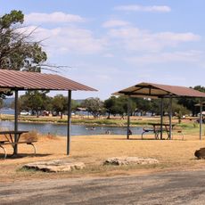
The park is west of Dallas-Fort Worth and works well for both day trips and overnight stays with camping. Trails cover different levels of difficulty, so hikers and cyclists can find routes that suit their pace.

The park opened to the public only in 2023, making it one of the newest state parks in Texas despite the land being acquired over a decade earlier. The gap between purchase and opening was due to the years needed to build all the facilities from the ground up.

The community of curious travelers

AroundUs brings together thousands of curated places, local tips, and hidden gems, enriched daily by 60,000 contributors worldwide.

Start exploring
GPS coordinates
32.53000,-98.57000
Latest update
March 3, 2026 14:02
Around this place
Fort Belknap
United States of America

Fort Belknap

70.9 km
Possum Kingdom State Park
United States of America

Possum Kingdom State Park

37.8 km
Proctor Lake
United States of America

Proctor Lake

61.4 km
Lake Mineral Wells State Park & Trailway
United States of America

Lake Mineral Wells State Park & Trailway

61.9 km
Robert E. Howard Museum
United States of America

Robert E. Howard Museum

72.6 km
Bluff Dale Suspension Bridge
United States of America

Bluff Dale Suspension Bridge

54.7 km
Barton Creek Bridge
United States of America

Barton Creek Bridge

20.8 km
Shackelford County Courthouse Historic District
United States of America

Shackelford County Courthouse Historic District

71.4 km
US 281 Bridge at the Brazos River
United States of America

US 281 Bridge at the Brazos River

45.8 km
Erath County Courthouse
United States of America

Erath County Courthouse

48.9 km
First Presbyterian Church
United States of America

First Presbyterian Church

52.9 km
Erath Memorial Arch
United States of America

Erath Memorial Arch

48.7 km
Dawson Saloon
United States of America

Dawson Saloon

48.9 km
Fort Belknap Historic Site
United States of America

Fort Belknap Historic Site

70.9 km
First National Bank Building
United States of America

First National Bank Building

48.8 km
Conrad N. Hilton Center & Museum
United States of America

Conrad N. Hilton Center & Museum

41.6 km
Brazos Drive In
United States of America

Brazos Drive In

72.3 km
National Theater
United States of America

National Theater

64.2 km
Majestic Theatre
United States of America

Majestic Theatre

27.4 km
Old Post Office Museum & Art Center
United States of America

Old Post Office Museum & Art Center

64.1 km
Comanche County Courthouse
United States of America

Comanche County Courthouse

70.5 km
Eastland County Museum
United States of America

Eastland County Museum

27.3 km
Robert E. Howard House
United States of America

Robert E. Howard House

72.6 km
State Highway 120 Bridge at the Brazos River
United States of America

State Highway 120 Bridge at the Brazos River

73.9 km
Possum Kingdom Bridge
United States of America

Possum Kingdom Bridge

39.4 km
Clairette Schoolhouse
United States of America

Clairette Schoolhouse

68.8 km
Granbury Railroad Depot
United States of America

Granbury Railroad Depot

74.1 km
Breckenridge Stephens Walker Home
United States of America

Breckenridge Stephens Walker Home

39.5 km
Show the full map
Reviews
Share your experience

No review yet

Discussions
Start a discussion...

No discussion yet

« Palo Pinto Mountains State Park - State park in Palo Pinto County, Texas » is provided by Around Us (aroundus.com). Images and texts are derived from Wikimedia project under a Creative Commons license. You are allowed to copy, distribute, and modify copies of this page, under the conditions set by the license, as long as this note is clearly visible.

Discover hidden gems everywhere you go!

From secret cafés to breathtaking viewpoints, skip the crowded tourist spots and find places that match your style. Our app makes it easy with voice search, smart filtering, route optimization, and insider tips from travelers worldwide. Download now for the complete mobile experience.

Around Us App Screenshot

A unique approach to discovering new places

Le Figaro

All the places worth exploring

France Info

A tailor-made excursion in just a few clicks

20 Minutes

Around Us
Travel Guide & Maps
Download

Send to your phone

QR Code
1

Open the camera app on your mobile.

2

Point at the QR code with your camera. A notification will appear.

3

Tap the notification to open the link.