Enable Location

We need your location to show you interesting places around you

Discover nearby places

Find interesting locations and hidden gems around you

Precise directions

Get accurate directions and distances to places

Your location is never shared with other users. It's only used when you tap the location button.

Arcade Building

Log in to your account

Start exploring — it's free

Trusted by 62,568 travelers worldwide

Continue with Google
Continue with Apple
or

We will send you a code to connect

By continuing, you accept our Terms and Conditions and our Privacy Policy

Check your inbox

We've sent a pincode in your inbox. Please enter the code below.

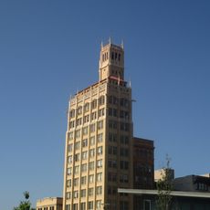
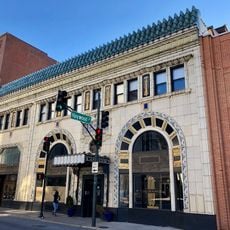
Arcade Building, listed on the NRHP in Buncombe County, North Carolina

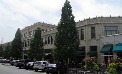
The Arcade Building is a commercial structure in Asheville completed in 1929 that spans an entire city block with a steel frame and concrete foundation. It features Tudor Revival and Late Gothic Revival architectural elements, molded terra cotta details, rounded corners, and a distinctive shape consisting of a lower rectangular section topped by a smaller set-back upper portion.

The building was constructed between 1926 and 1929 and designed by architect Charles N. Parker for E.W. Grove, an industrialist who sought to develop Asheville as a health destination. It was added to the National Register of Historic Places in 1976 and served as the headquarters for the National Climatic Data Center until 1995 when the federal government occupied it during and after World War II.

The building originally served as a public market where people from the region gathered to buy and sell goods and socialize. Today it continues this tradition as a meeting place in downtown Asheville where visitors and residents shop, dine, and gather together.

The building contains shops and restaurants on the ground floor, offices on middle levels, and apartments on upper floors that visitors can explore freely. Take time to walk through and notice the architectural details including the winged lions on the north side and the spiral staircase that add to the experience.

The building was one of the first enclosed shopping centers in the United States and represented a revolutionary design concept for its era. Venetian architectural influences appear in details like the winged lions on the facade, bringing European sophistication to American commercial development.

The community of curious travelers

AroundUs brings together thousands of curated places, local tips, and hidden gems, enriched daily by 60,000 contributors worldwide.

Start exploring
Location
GPS coordinates
35.59560,-82.55670
Latest update
February 9, 2026 08:23
Around this place
Thomas Wolfe House
United States of America

Thomas Wolfe House

572 m
The Orange Peel
United States of America

The Orange Peel

697 m
Downtown Asheville Historic District
United States of America

Downtown Asheville Historic District

315 m
Jackson Building
United States of America

Jackson Building

567 m
Zealandia
United States of America

Zealandia

1.6 km
Asheville City Hall
United States of America

Asheville City Hall

732 m
S & W Cafeteria
United States of America

S & W Cafeteria

287 m
Asheville Art Museum
United States of America

Asheville Art Museum

533 m
Asheville Masonic Temple
United States of America

Asheville Masonic Temple

476 m
Buncombe County Courthouse
United States of America

Buncombe County Courthouse

734 m
Young Men's Institute Building
United States of America

Young Men's Institute Building

609 m
Demens-Rumbough-Crawley House
United States of America

Demens-Rumbough-Crawley House

1.1 km
Pack Memorial Library
United States of America

Pack Memorial Library

167 m
Building at 134–136½ Biltmore Avenue
United States of America

Building at 134–136½ Biltmore Avenue

778 m
Chestnut Hill Historic District
United States of America

Chestnut Hill Historic District

1.2 km
Ravenscroft School
United States of America

Ravenscroft School

519 m
St. Matthias Episcopal Church
United States of America

St. Matthias Episcopal Church

876 m
Mrs. Minnie Alexander Cottage
United States of America

Mrs. Minnie Alexander Cottage

506 m
Whitford G. Smith House
United States of America

Whitford G. Smith House

481 m
George A. Mears House
United States of America

George A. Mears House

778 m
Claxton School
United States of America

Claxton School

1.4 km
Clingman Avenue Historic District
United States of America

Clingman Avenue Historic District

863 m
Building at 140 Biltmore Avenue
United States of America

Building at 140 Biltmore Avenue

778 m
Riverside Industrial Historic District
United States of America

Riverside Industrial Historic District

1.4 km
Building at 130–132 Biltmore Avenue
United States of America

Building at 130–132 Biltmore Avenue

778 m
Riverside Cemetery
United States of America

Riverside Cemetery

1.4 km
Moogseum
United States of America

Moogseum

452 m
Montford Area Historic District
United States of America

Montford Area Historic District

1.1 km
Show the full map
« Arcade Building - listed on the NRHP in Buncombe County, North Carolina » is provided by Around Us (aroundus.com). Images and texts are derived from Wikimedia project under a Creative Commons license. You are allowed to copy, distribute, and modify copies of this page, under the conditions set by the license, as long as this note is clearly visible.

Discover hidden gems everywhere you go!

From secret cafés to breathtaking viewpoints, skip the crowded tourist spots and find places that match your style. Our app makes it easy with voice search, smart filtering, route optimization, and insider tips from travelers worldwide. Download now for the complete mobile experience.

Around Us App Screenshot

A unique approach to discovering new places

Le Figaro

All the places worth exploring

France Info

A tailor-made excursion in just a few clicks

20 Minutes

Around Us
Travel Guide & Maps
Download

Send to your phone

QR Code
1

Open the camera app on your mobile.

2

Point at the QR code with your camera. A notification will appear.

3

Tap the notification to open the link.