Enable Location

We need your location to show you interesting places around you

Discover nearby places

Find interesting locations and hidden gems around you

Precise directions

Get accurate directions and distances to places

Your location is never shared with other users. It's only used when you tap the location button.

King Street Overhead Bridge

Log in to your account

Start exploring — it's free

Trusted by 61,818 travelers worldwide

Continue with Google
Continue with Apple
or

We will send you a code to connect

By continuing, you accept our Terms and Conditions and our Privacy Policy

Check your inbox

We've sent a pincode in your inbox. Please enter the code below.

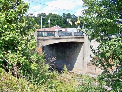
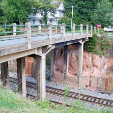
King Street Overhead Bridge, Historic concrete bridge in Kings Mountain, United States

Description

King Street Overhead Bridge is a concrete structure in Kings Mountain that carries West King Street over Norfolk Southern Railway tracks. The bridge connects both sides of the railroad area and allows traffic to pass over the tracks at this location.

History

The structure was designed and built by engineer William L. Craven between 1938 and 1939 during a period of infrastructure expansion in the region. It was added to the National Register of Historic Places in 2005 and has been recognized as a protected monument since then.

Culture

The bridge displays Moderne-style design choices visible in its concrete frame and proportions. Walking across it, you notice details that reflect how engineers of that era balanced practical engineering with visual form.

Practical

The structure connects Battleground Avenue with Railroad Avenue and allows vehicles to pass safely over the railroad tracks. Visitors should be aware that trains sometimes pass beneath the bridge and watch for traffic on the street itself.

Did you know?

The structure is an example of rigid-frame construction using reinforced concrete, where columns and beams are joined without expansion joints. This technique was an advanced solution in the 1930s for stable and economical bridge building.

Location
Inception
1939
GPS coordinates
35.24080,-81.34470
Latest update
December 14, 2025 18:46

AroundUs brings together thousands of curated places, local tips, and hidden gems, enriched daily by 60,000 contributors worldwide. Discover all places nearby (Kings Mountain).

Around this place
U.S. Route 29
United States of America

U.S. Route 29

12.6 km
Crowders Mountain State Park
United States of America

Crowders Mountain State Park

6.2 km
CaroMont Health Park
United States of America

CaroMont Health Park

13.8 km
Kings Mountain State Park
United States of America

Kings Mountain State Park

12.3 km
Gaston County Courthouse
United States of America

Gaston County Courthouse

14.8 km
Webbley
United States of America

Webbley

18.4 km
Downtown Gastonia Historic District
United States of America

Downtown Gastonia Historic District

14.9 km
Beam's Shell Service Station and Office
United States of America

Beam's Shell Service Station and Office

15.8 km
West End Historic District
United States of America

West End Historic District

541 m
Third National Bank Building
United States of America

Third National Bank Building

14.8 km
Loray Mill Historic District
United States of America

Loray Mill Historic District

13.5 km
Kings Mountain Historical Museum
United States of America

Kings Mountain Historical Museum

289 m
Masonic Temple Building
United States of America

Masonic Temple Building

18.2 km
First National Bank Building
United States of America

First National Bank Building

14.9 km
Joshua Beam House
United States of America

Joshua Beam House

17.4 km
George Sperling House and Outbuildings
United States of America

George Sperling House and Outbuildings

18.2 km
Central School Historic District
United States of America

Central School Historic District

282 m
William J. Wilson House
United States of America

William J. Wilson House

14.2 km
Southern Railway Company Overhead Bridge
United States of America

Southern Railway Company Overhead Bridge

67 m
Dallas Historic District
United States of America

Dallas Historic District

17.4 km
Jacob S. Mauney Memorial Library and Teacher's Home
United States of America

Jacob S. Mauney Memorial Library and Teacher's Home

175 m
Margrace Mill Village Historic District
United States of America

Margrace Mill Village Historic District

2.4 km
Clover Downtown Historic District
United States of America

Clover Downtown Historic District

17.9 km
Central School
United States of America

Central School

7.9 km
Bessemer City Downtown Historic District
United States of America

Bessemer City Downtown Historic District

7.3 km
Cleveland County Training School
United States of America

Cleveland County Training School

18.3 km
Robinson-Gardner Building
United States of America

Robinson-Gardner Building

14.9 km
Kings Mountain National Military Park Visitor Center
United States of America

Kings Mountain National Military Park Visitor Center

11.5 km
Show the full map
« King Street Overhead Bridge - Historic concrete bridge in Kings Mountain, United States » is provided by Around Us (aroundus.com). Images and texts are derived from Wikimedia project under a Creative Commons license. You are allowed to copy, distribute, and modify copies of this page, under the conditions set by the license, as long as this note is clearly visible.

Discover hidden gems everywhere you go!

From secret cafés to breathtaking viewpoints, skip the crowded tourist spots and find places that match your style. Our app makes it easy with voice search, smart filtering, route optimization, and insider tips from travelers worldwide. Download now for the complete mobile experience.

Around Us App Screenshot

A unique approach to discovering new places

Le Figaro

All the places worth exploring

France Info

A tailor-made excursion in just a few clicks

20 Minutes

Around Us
Travel Guide & Maps
Download

Send to your phone

QR Code
1

Open the camera app on your mobile.

2

Point at the QR code with your camera. A notification will appear.

3

Tap the notification to open the link.