Punchbowl Formation

Log in to your account

AroundUs is a community-driven map of interesting places, built by curious explorers like you. It grows with every review, story, and photo you share.
Connect to save your favorite spots, contribute locations, and create personalized routes.
By continuing, you accept our Terms and Conditions and our Privacy Policy

Punchbowl Formation

Add to collection
Map
Suggest a change
Share

Punchbowl Formation, Sandstone formation in Los Angeles County, California.
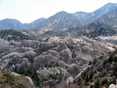
The Punchbowl Formation extends across the northern San Gabriel Mountains, featuring layers of conglomerate, sandstone, and mudstone deposits reaching 1,500 meters in thickness.

Dating from the Mid-Late Miocene period between 14 to 8 million years ago, this formation developed through extensive sedimentary processes during the Clarendonian and Hemphillian ages.

Scientists regularly study this formation to understand geological processes, examining fossil records of ancient mammals including Aepycamelus alexandrae and various carnivorous species.

The formation is accessible through the Devil's Punchbowl Natural Area within Angeles National Forest, where visitors can examine the exposed rock layers and geological structures.

The formation contains a substantial collection of Neogene period fossils, including remains of turtles from the Gopherus depressus species and multiple rodent specimens.

Location: California

GPS coordinates: 34.00000,-118.20000

Latest update: March 9, 2025 02:19

Around this place
Show the full map
Sixth Street Viaduct
United States of America

Sixth Street Viaduct

4.9 km
Atchison, Topeka and Santa Fe Railway 3751
United States of America

Atchison, Topeka and Santa Fe Railway 3751

3 km
Evergreen Cemetery
United States of America

Evergreen Cemetery

4.7 km
Commerce Casino
United States of America

Commerce Casino

5.1 km
South Central Farm
United States of America

South Central Farm

3.9 km
Sears, Roebuck & Company Mail Order Building
United States of America

Sears, Roebuck & Company Mail Order Building

3.2 km
Bicycle Casino
United States of America

Bicycle Casino

4.9 km
Coca-Cola Building
United States of America

Coca-Cola Building

5.2 km
Mariachi Plaza
United States of America

Mariachi Plaza

5.6 km
Breed Street Shul
United States of America

Breed Street Shul

5.3 km
Golden Gate Theater
United States of America

Golden Gate Theater

4.6 km
El Mercado de Los Angeles
United States of America

El Mercado de Los Angeles

4.2 km
28th Street YMCA
United States of America

28th Street YMCA

5.6 km
27th Street Historic District
United States of America

27th Street Historic District

5.6 km
Ralph J. Bunche House
United States of America

Ralph J. Bunche House

5 km
Lincoln Theatre
United States of America

Lincoln Theatre

5.5 km
Boyle Hotel – Cummings Block
United States of America

Boyle Hotel – Cummings Block

5.6 km
52nd Place Historic District
United States of America

52nd Place Historic District

5.8 km
Roosevelt Building
United States of America

Roosevelt Building

5.6 km
Prince Hall Masonic Temple
United States of America

Prince Hall Masonic Temple

5.3 km
Bethlehem Baptist Church (Los Angeles)
United States of America

Bethlehem Baptist Church (Los Angeles)

4.4 km
Golden State Mutual Life Insurance Building
United States of America

Golden State Mutual Life Insurance Building

5.2 km
Robert Louis Stevenson Branch
United States of America

Robert Louis Stevenson Branch

3.1 km
Malabar Branch
United States of America

Malabar Branch

5.6 km
Luna Luna
United States of America

Luna Luna

4.9 km
African American Firefighter Museum
United States of America

African American Firefighter Museum

5.4 km
4th Street bridge
United States of America

4th Street bridge

5.3 km
Maywood Cesar Chavez Library
United States of America

Maywood Cesar Chavez Library

1.7 km
Show the full map

Reviews

Visited this place? Tap the stars to rate it and share your experience / photos with the community! Try now! You can cancel it anytime.

« Punchbowl Formation: Sandstone formation in Los Angeles County, California » is provided by Around Us (aroundus.com). Images and texts are derived from Wikimedia project under a Creative Commons license. You are allowed to copy, distribute, and modify copies of this page, under the conditions set by the license, as long as this note is clearly visible.

Discover hidden gems everywhere you go!

From secret cafés to breathtaking viewpoints, skip the crowded tourist spots and find places that match your style. Our app makes it easy with voice search, smart filtering, route optimization, and insider tips from travelers worldwide. Download now for the complete mobile experience.

Around Us App Screenshot

A unique approach to discovering new places

Le Figaro

All the places worth exploring

France Info

A tailor-made excursion in just a few clicks

20 Minutes