Enable Location

We need your location to show you interesting places around you

Discover nearby places

Find interesting locations and hidden gems around you

Precise directions

Get accurate directions and distances to places

Your location is never shared with other users. It's only used when you tap the location button.

Diversion Dam and Deer Flat Embankments

Log in to your account

Start exploring — it's free

Trusted by 61,770 travelers worldwide

Continue with Google
Continue with Apple
or

We will send you a code to connect

By continuing, you accept our Terms and Conditions and our Privacy Policy

Check your inbox

We've sent a pincode in your inbox. Please enter the code below.

Diversion Dam and Deer Flat Embankments, Historic dam and embankment system in Ada County and Canyon County, United States.

Description

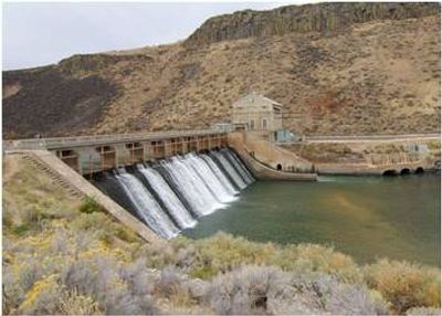
The Diversion Dam and Deer Flat Embankments comprise three interconnected structures that regulate water flow across southwestern Idaho's farming regions. These components spread across two counties and work together to manage the water supply that sustains the Treasure Valley's agricultural economy.

History

Engineers built these structures between 1906 and 1912 as part of the Bureau of Reclamation's Boise Project, bringing irrigation to southwestern Idaho's dry landscape. This construction represented a broader federal effort to develop water resources across the American West during the early 20th century.

Culture

The dam system represents a turning point in how this region developed, marking the shift from sparse settlement to thriving agricultural communities. Local farmers and residents see these structures as foundational to the prosperity they experience today.

Practical

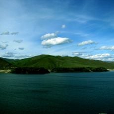
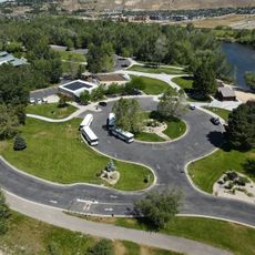
These structures are viewable from public roads and accessible viewing areas that allow you to see the overall system and understand how it functions. Visit during the irrigation season to see the dams actively distributing water across the farmland and get a sense of their working purpose.

Did you know?

The system combines the Boise River Diversion Dam with two earth embankments, serving a dual purpose as both an irrigation supplier and a source of hydroelectric power. This combined approach to water management and power generation was an innovative solution when it was first built.

Location
Location
GPS coordinates
43.53781,-116.09341
Latest update
December 14, 2025 17:41

AroundUs brings together thousands of curated places, local tips, and hidden gems, enriched daily by 60,000 contributors worldwide. Discover all places nearby (Ada County).

Around this place
Albertsons Stadium
United States of America

Albertsons Stadium

11 km
Old Idaho State Penitentiary
United States of America

Old Idaho State Penitentiary

9.1 km
Lucky Peak State Park
United States of America

Lucky Peak State Park

2.9 km
Lucky Peak Lake
United States of America

Lucky Peak Lake

4.3 km
Idaho Botanical Garden
United States of America

Idaho Botanical Garden

8.9 km
Old Idaho Penitentiary Site
United States of America

Old Idaho Penitentiary Site

9.1 km
National Weather Service Boise, Idaho
United States of America

National Weather Service Boise, Idaho

10.1 km
MK Nature Center
United States of America

MK Nature Center

10.2 km
Warm Springs Avenue Historic District
United States of America

Warm Springs Avenue Historic District

10.4 km
Christ Chapel
United States of America

Christ Chapel

10.9 km
Barber Park
United States of America

Barber Park

4.9 km
Boise Junior College Administration Building
United States of America

Boise Junior College Administration Building

11.5 km
Garfield School
United States of America

Garfield School

9.9 km
Moore–Cunningham House
United States of America

Moore–Cunningham House

10.4 km
United States of America

Artesian Water Co. Pumphouse and Wells

9.3 km
Idaho National Guard Armory
United States of America

Idaho National Guard Armory

11.2 km
West Warm Springs Historic District
United States of America

West Warm Springs Historic District

11.6 km
Mrs. A. F. Rossi House
United States of America

Mrs. A. F. Rossi House

10.9 km
Bishop Funsten House
United States of America

Bishop Funsten House

9.1 km
Hopffgarten House
United States of America

Hopffgarten House

10.1 km
John Regan American Legion Hall
United States of America

John Regan American Legion Hall

11.3 km
Rosedale Odd Fellows Temple
United States of America

Rosedale Odd Fellows Temple

10 km
Nathan Smith House
United States of America

Nathan Smith House

9.5 km
Roosevelt School
United States of America

Roosevelt School

10.7 km
Reclamation Service Boise Project Office
United States of America

Reclamation Service Boise Project Office

11.3 km
C. C. Cavanah House
United States of America

C. C. Cavanah House

11.5 km
H. C. Burnett House
United States of America

H. C. Burnett House

8.8 km
Joseph Chitwood House
United States of America

Joseph Chitwood House

10.4 km
Show the full map
« Diversion Dam and Deer Flat Embankments - Historic dam and embankment system in Ada County and Canyon County, United States » is provided by Around Us (aroundus.com). Images and texts are derived from Wikimedia project under a Creative Commons license. You are allowed to copy, distribute, and modify copies of this page, under the conditions set by the license, as long as this note is clearly visible.

Discover hidden gems everywhere you go!

From secret cafés to breathtaking viewpoints, skip the crowded tourist spots and find places that match your style. Our app makes it easy with voice search, smart filtering, route optimization, and insider tips from travelers worldwide. Download now for the complete mobile experience.

Around Us App Screenshot

A unique approach to discovering new places

Le Figaro

All the places worth exploring

France Info

A tailor-made excursion in just a few clicks

20 Minutes

Around Us
Travel Guide & Maps
Download

Send to your phone

QR Code
1

Open the camera app on your mobile.

2

Point at the QR code with your camera. A notification will appear.

3

Tap the notification to open the link.