Enable Location

We need your location to show you interesting places around you

Discover nearby places

Find interesting locations and hidden gems around you

Precise directions

Get accurate directions and distances to places

Your location is never shared with other users. It's only used when you tap the location button.

Log in to your account

Start exploring — it's free

Trusted by 62,396 travelers worldwide

Continue with Google
Continue with Apple
or

We will send you a code to connect

By continuing, you accept our Terms and Conditions and our Privacy Policy

Check your inbox

We've sent a pincode in your inbox. Please enter the code below.

Schumaker Pond

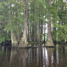
Schumaker Pond, pond in Maryland

Schumaker Pond is a reservoir created by damming Beaverdam Creek, a tributary of the Wicomico River, and is located in Salisbury City Park. Trees overhang the water with branches dipping down, while open grassy banks surround the shoreline and make the terrain easy to walk.

In the mid-twentieth century, the pond was a popular swimming destination where local families came to swim and enjoy the calm waters. As development spread in the surrounding areas, water quality gradually declined until swimming became unsafe today.

The pond remains a gathering place where the community comes together to observe nature and spend time outdoors. The walking trails and observation points show how residents and visitors use the space today to connect with local wildlife.

The area is easy to reach on foot, with walking trails around it best suited for strolling, and parking is available nearby, including a paved lot at the former Ward Museum site. Paddling such as kayaking is popular in warmer months, and various facilities help visitors plan their time and explore the area comfortably.

The pond was once home to the Ward Museum, which celebrated the tradition of decoy carving, a local art form closely tied to the region's waterfowl culture. Though the museum closed in 2022 due to a mold problem, the location still echoes this craftsmanship heritage and draws visitors interested in exploring the historical connections between the community and the water.

The community of curious travelers

AroundUs brings together thousands of curated places, local tips, and hidden gems, enriched daily by 60,000 contributors worldwide.

Start exploring
Location
GPS coordinates
38.34920,-75.56560
Latest update
February 9, 2026 08:18
Around this place
Trap Pond State Park
United States of America

Trap Pond State Park

21.4 km
Arthur W. Perdue Stadium
United States of America

Arthur W. Perdue Stadium

3.9 km
Teackle Mansion
United States of America

Teackle Mansion

20.2 km
Pemberton Hall
United States of America

Pemberton Hall

6.9 km
Poplar Hill Mansion
United States of America

Poplar Hill Mansion

3.6 km
Nassawango Iron Furnace Site
United States of America

Nassawango Iron Furnace Site

18.2 km
United States of America

Wicomico Demonstration Forest

11.3 km
Salisbury University Arboretum
United States of America

Salisbury University Arboretum

3.6 km
Old Friendship United Methodist Church
United States of America

Old Friendship United Methodist Church

14.1 km
Waterloo
United States of America

Waterloo

21.3 km
Beckford
United States of America

Beckford

20.2 km
Gillis-Grier House
United States of America

Gillis-Grier House

3.7 km
Princess Anne Historic District
United States of America

Princess Anne Historic District

19.7 km
Sen. William P. Jackson House
United States of America

Sen. William P. Jackson House

3.7 km
Maude R. Toulson Federal Building
United States of America

Maude R. Toulson Federal Building

3.5 km
Spring Hill Church
United States of America

Spring Hill Church

13 km
Bounds Lott
United States of America

Bounds Lott

16.6 km
Mount Zion Memorial Church
United States of America

Mount Zion Memorial Church

18.5 km
Perry-Cooper House
United States of America

Perry-Cooper House

3.6 km
White Hall
United States of America

White Hall

16.6 km
Bennett's Adventure
United States of America

Bennett's Adventure

16.5 km
F. Leonard Wailes Law Office
United States of America

F. Leonard Wailes Law Office

3.5 km
Asbury Methodist Episcopal Church
United States of America

Asbury Methodist Episcopal Church

12.7 km
Catalpa Farm
United States of America

Catalpa Farm

20.7 km
Stanley Potato House
United States of America

Stanley Potato House

18.9 km
St. Giles
United States of America

St. Giles

13.7 km
Ward Museum of Wildfowl Art
United States of America

Ward Museum of Wildfowl Art

586 m
Furnace Town Historic Site (Nassawango Iron Furnace)
United States of America

Furnace Town Historic Site (Nassawango Iron Furnace)

18.2 km
Show the full map
« Schumaker Pond - pond in Maryland » is provided by Around Us (aroundus.com). Images and texts are derived from Wikimedia project under a Creative Commons license. You are allowed to copy, distribute, and modify copies of this page, under the conditions set by the license, as long as this note is clearly visible.

Discover hidden gems everywhere you go!

From secret cafés to breathtaking viewpoints, skip the crowded tourist spots and find places that match your style. Our app makes it easy with voice search, smart filtering, route optimization, and insider tips from travelers worldwide. Download now for the complete mobile experience.

Around Us App Screenshot

A unique approach to discovering new places

Le Figaro

All the places worth exploring

France Info

A tailor-made excursion in just a few clicks

20 Minutes

Around Us
Travel Guide & Maps
Download

Send to your phone

QR Code
1

Open the camera app on your mobile.

2

Point at the QR code with your camera. A notification will appear.

3

Tap the notification to open the link.