US Coast Guard and Geodetic Survey Seismological and Geomagnetic House

Log in to your account

AroundUs is a community-driven map of interesting places, built by curious explorers like you. It grows with every review, story, and photo you share.
Connect to save your favorite spots, contribute locations, and create personalized routes.
Continue with Google
Continue with Apple
Continue with X
Continue with Facebook
Continue with email
By continuing, you accept our Terms and Conditions and our Privacy Policy
Create an account

US Coast Guard and Geodetic Survey Seismological and Geomagnetic House

Add to collection
Map
Suggest a change
Share

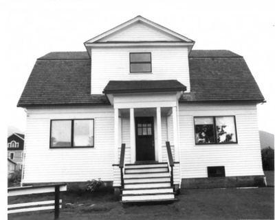
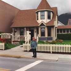
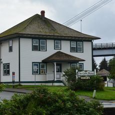
US Coast Guard and Geodetic Survey Seismological and Geomagnetic House, Scientific observation building in Sitka, United States.

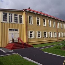
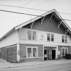
The US Coast Guard and Geodetic Survey Seismological and Geomagnetic House at 210 Seward Street is a two-story wood-sided structure with a gambrel roof design. It contains seven rooms arranged with three bedrooms upstairs and scientific workspaces below, featuring a concrete basement set directly into bedrock for stability and instrument protection.

Built in 1916 by the United States Department of Commerce, it operated as the first permanent geomagnetic observatory in Alaska through 1940. The facility supported early scientific research into Earth's magnetic properties from this remote northern location.

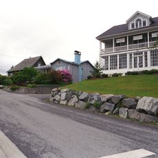
The site once hosted the Russian Tea Garden, a remnant from when Russia controlled the territory before ceding Alaska to the United States in 1867. This location marks a transition point between two colonial periods in the town's history.

The building sits on solid bedrock, which provides a stable foundation visible in its basement construction and important for understanding the site's scientific purpose. The location on Seward Street is easily accessible, and the exterior wood and roof details are clearly visible when walking past the structure.

The site was selected specifically because the absence of local magnetic disturbances allowed precise measurements of Earth's magnetic field. This geographical advantage made Sitka one of the few locations where such sensitive research could be conducted reliably during that era.

Location: Sitka

GPS coordinates: 57.05111,-135.33500

Latest update: December 14, 2025 18:45

Photos
Around this place
Mount Edgecumbe
United States of America

Mount Edgecumbe

25.8 km
Castle Hill
United States of America

Castle Hill

273 m
Sitka National Historical Park
United States of America

Sitka National Historical Park

1.4 km
Sheldon Jackson College
United States of America

Sheldon Jackson College

858 m
Russian Bishops House
United States of America

Russian Bishops House

231 m
United States of America

Coast Guard Air Station Sitka

2 km
Alaska Raptor Center
United States of America

Alaska Raptor Center

1.2 km
Sitka Pioneer Home
United States of America

Sitka Pioneer Home

168 m
John O'Connell Bridge
United States of America

John O'Connell Bridge

497 m
Blue Lake
United States of America

Blue Lake

10.7 km
Baranof Cross-Island Trail
United States of America

Baranof Cross-Island Trail

21.6 km
United States of America

Saint Lazaria Wilderness

23.5 km
Sitka Naval Operating Base and U.S. Army Coastal Defenses
United States of America

Sitka Naval Operating Base and U.S. Army Coastal Defenses

1.8 km
Sitka National Cemetery
United States of America

Sitka National Cemetery

1.2 km
Alaska Native Brotherhood Hall
United States of America

Alaska Native Brotherhood Hall

269 m
Russian-American Building No. 29
United States of America

Russian-American Building No. 29

232 m
United States of America

Mount Furuhelm

24.4 km
See House
United States of America

See House

492 m
Hanlon-Osbakken House
United States of America

Hanlon-Osbakken House

374 m
Cable House and Station
United States of America

Cable House and Station

372 m
Sitka United States Post Office and Court House
United States of America

Sitka United States Post Office and Court House

255 m
W.P. Mills House
United States of America

W.P. Mills House

527 m
Mills House
United States of America

Mills House

69 m
United States of America

Simpson Rock

3.5 km
Neva Island
United States of America

Neva Island

4.5 km
United States of America

Nevski Island

1.9 km
Saint Lazaria Islands
United States of America

Saint Lazaria Islands

23.6 km
United States of America

Alice Island

754 m
Show the full map
Reviews

Visited this place? Tap the stars to rate it and share your experience / photos with the community! Try now! You can cancel it anytime.

« US Coast Guard and Geodetic Survey Seismological and Geomagnetic House - Scientific observation building in Sitka, United States » is provided by Around Us (aroundus.com). Images and texts are derived from Wikimedia project under a Creative Commons license. You are allowed to copy, distribute, and modify copies of this page, under the conditions set by the license, as long as this note is clearly visible.

Discover hidden gems everywhere you go!

From secret cafés to breathtaking viewpoints, skip the crowded tourist spots and find places that match your style. Our app makes it easy with voice search, smart filtering, route optimization, and insider tips from travelers worldwide. Download now for the complete mobile experience.

Around Us App Screenshot

A unique approach to discovering new places

Le Figaro

All the places worth exploring

France Info

A tailor-made excursion in just a few clicks

20 Minutes