Enable Location

We need your location to show you interesting places around you

Discover nearby places

Find interesting locations and hidden gems around you

Precise directions

Get accurate directions and distances to places

Your location is never shared with other users. It's only used when you tap the location button.

Scudders Falls

Log in to your account

Start exploring — it's free

Trusted by 61,334 travelers worldwide

Continue with Google
Continue with Apple
or

We will send you a code to connect

By continuing, you accept our Terms and Conditions and our Privacy Policy

Check your inbox

We've sent a pincode in your inbox. Please enter the code below.

Scudders Falls

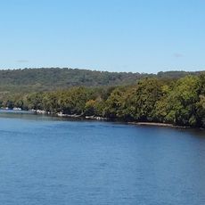
Scudders Falls, Rapids system on Delaware River between Ewing Township and Lower Makefield, United States

Description

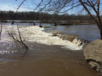
Scudders Falls is a rapids system on the Delaware River that spans roughly 600 feet with a drop of about 10 feet distributed across multiple channels. The water flows through these channels at varying speeds, creating different sections of whitewater.

History

The area takes its name from Richard Betts Scudder, who established himself near these rapids in the early 1700s. The location became known as a notable point along the Delaware River.

Culture

The Delaware River Joint Toll Bridge Commission maintains interpretation signs explaining the geological formation of the rapids and their role in navigation.

Practical

Visitors can access the rapids from multiple points along the riverbank, but water levels change with weather and season. Checking conditions before visiting helps ensure you experience the rapids safely at their best.

Did you know?

The rapids take their name from an early settler and remain a destination where paddlers of different skill levels find suitable conditions. Both beginners and experienced kayakers find opportunities to paddle here depending on water flow.

Location
Part of
Delaware River
GPS coordinates
40.26694,-74.85278
Latest update
December 13, 2025 12:24

AroundUs brings together thousands of curated places, local tips, and hidden gems, enriched daily by 60,000 contributors worldwide. Discover all places nearby (Bucks County).

Around this place
Washington's Crossing
United States of America

Washington's Crossing

3.6 km
Washington Crossing Historic Park
United States of America

Washington Crossing Historic Park

3.9 km
Scudder Falls Bridge
United States of America

Scudder Falls Bridge

1 km
Trenton Bath House
United States of America

Trenton Bath House

4.6 km
Washington Crossing State Park
United States of America

Washington Crossing State Park

5 km
Washington Crossing Bridge
United States of America

Washington Crossing Bridge

3.4 km
United States of America

Washington Crossing National Cemetery

4.4 km
West Trenton Railroad Bridge
United States of America

West Trenton Railroad Bridge

3.7 km
Yardley–Wilburtha Bridge
United States of America

Yardley–Wilburtha Bridge

2.8 km
Mansion House
United States of America

Mansion House

6.4 km
John Burroughs Homestead
United States of America

John Burroughs Homestead

4.5 km
Bear Tavern Road--Jacob's Creek Crossing Rural Historic District
United States of America

Bear Tavern Road--Jacob's Creek Crossing Rural Historic District

3.5 km
Dolington Village Historic District
United States of America

Dolington Village Historic District

3.7 km
Jeremiah Woolsey House
United States of America

Jeremiah Woolsey House

5.2 km
Benjamin Taylor Homestead
United States of America

Benjamin Taylor Homestead

5.1 km
Bridge in Yardley Borough
United States of America

Bridge in Yardley Borough

4 km
Washington Crossing State Park
United States of America

Washington Crossing State Park

4.6 km
Makefield Meeting
United States of America

Makefield Meeting

2.9 km
Village of Edgewood Historic District
United States of America

Village of Edgewood Historic District

5.3 km
John and Phineas Hough House
United States of America

John and Phineas Hough House

4.6 km
Green-Reading House
United States of America

Green-Reading House

2.4 km
Hart–Hoch House
United States of America

Hart–Hoch House

5.8 km
Ellarslie
United States of America

Ellarslie

6.4 km
Yardley Historic District
United States of America

Yardley Historic District

3.2 km
McConkey's Ferry Inn
United States of America

McConkey's Ferry Inn

3.4 km
Nelson House
United States of America

Nelson House

3.5 km
Johnson Ferry House
United States of America

Johnson Ferry House

3.8 km
Titusville Historic District
United States of America

Titusville Historic District

4.9 km
Show the full map
« Scudders Falls - Rapids system on Delaware River between Ewing Township and Lower Makefield, United States » is provided by Around Us (aroundus.com). Images and texts are derived from Wikimedia project under a Creative Commons license. You are allowed to copy, distribute, and modify copies of this page, under the conditions set by the license, as long as this note is clearly visible.

Discover hidden gems everywhere you go!

From secret cafés to breathtaking viewpoints, skip the crowded tourist spots and find places that match your style. Our app makes it easy with voice search, smart filtering, route optimization, and insider tips from travelers worldwide. Download now for the complete mobile experience.

Around Us App Screenshot

A unique approach to discovering new places

Le Figaro

All the places worth exploring

France Info

A tailor-made excursion in just a few clicks

20 Minutes

Around Us
Travel Guide & Maps
Download

Send to your phone

QR Code
1

Open the camera app on your mobile.

2

Point at the QR code with your camera. A notification will appear.

3

Tap the notification to open the link.