Enable Location

We need your location to show you interesting places around you

Discover nearby places

Find interesting locations and hidden gems around you

Precise directions

Get accurate directions and distances to places

Your location is never shared with other users. It's only used when you tap the location button.

Loco Mountain

Log in to your account

Start exploring — it's free

Trusted by 62,567 travelers worldwide

Continue with Google
Continue with Apple
or

We will send you a code to connect

By continuing, you accept our Terms and Conditions and our Privacy Policy

Check your inbox

We've sent a pincode in your inbox. Please enter the code below.

Loco Mountain

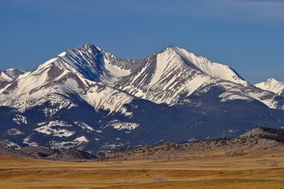
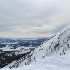
Loco Mountain, Mountain summit in Meagher County, Montana, United States.

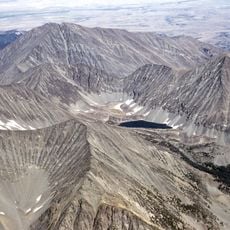
Loco Mountain is a rocky peak within the Crazy Mountains range, characterized by steep terrain and exposed rock. The summit area features the weathered stone and rough surfaces typical of high alpine landscapes.

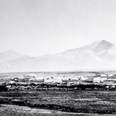
The peak was officially recorded through U.S. mapping surveys and incorporated into the Lewis and Clark National Forest management system. This occurred as part of the systematic cataloging of Montana's mountain landscape in the 20th century.

Local mountaineering groups maintain records of ascents to Loco Mountain's summit, documenting the experiences of climbers who reach its peak.

Access is gained via Highway 191 approaching the eastern slopes of the Crazy Mountains, requiring hiking through Lewis and Clark National Forest. Visitors should prepare for alpine conditions and weather changes typical of high elevations.

The peak has a prominence of about 1,559 feet (475 meters) and stands roughly 6.55 kilometers from the nearest neighboring summit. This isolation makes it a standalone peak within the local mountain group.

The community of curious travelers

AroundUs brings together thousands of curated places, local tips, and hidden gems, enriched daily by 60,000 contributors worldwide.

Start exploring
Location
GPS coordinates
46.22467,-110.33575
Latest update
December 14, 2025 18:16
Around this place
The Murray Hotel
United States of America

The Murray Hotel

65.1 km
Fort Ellis
United States of America

Fort Ellis

80.5 km
Crazy Peak
United States of America

Crazy Peak

23.5 km
Bozeman Depot
United States of America

Bozeman Depot

80.1 km
Greycliff Prairie Dog Town State Park
United States of America

Greycliff Prairie Dog Town State Park

67.3 km
Byron R. Sherman House
United States of America

Byron R. Sherman House

56.5 km
DePuy Spring Creek
United States of America

DePuy Spring Creek

76.4 km
Bridger Bowl Ski Area
United States of America

Bridger Bowl Ski Area

62.7 km
Bozeman Public Library
United States of America

Bozeman Public Library

80.9 km
Milwaukee Road Historic District
United States of America

Milwaukee Road Historic District

45.3 km
Judith River Ranger Station
United States of America

Judith River Ranger Station

69.4 km
Parberry Block East
United States of America

Parberry Block East

56.5 km
Dry Creek School
United States of America

Dry Creek School

78.9 km
Carnegie Public Library
United States of America

Carnegie Public Library

52.8 km
B Street District
United States of America

B Street District

65.1 km
Rolfson House
United States of America

Rolfson House

67.8 km
Bohart House
United States of America

Bohart House

80.5 km
Melville Lutheran Church
United States of America

Melville Lutheran Church

27.9 km
College 'M' Steep Trail
United States of America

College 'M' Steep Trail

75.5 km
Cherry River Fishing access

Cherry River Fishing access

79.6 km
Livingston Depot
United States of America

Livingston Depot

65.1 km
Big Timber Lutheran Church
United States of America

Big Timber Lutheran Church

52.8 km
Charles M Bair Family Museum
United States of America

Charles M Bair Family Museum

26.9 km
Redeemer Lutheran Church (Livingston, Montana)
United States of America

Redeemer Lutheran Church (Livingston, Montana)

65.5 km
St Mark's Episcopal Church (Big Timber)
United States of America

St Mark's Episcopal Church (Big Timber)

52.8 km
Empire Twin Theater
United States of America

Empire Twin Theater

65.1 km
Smith River Valley Historical Marker
United States of America

Smith River Valley Historical Marker

49.4 km
Teslow Grain Elevator
United States of America

Teslow Grain Elevator

64.4 km
Show the full map
« Loco Mountain - Mountain summit in Meagher County, Montana, United States » is provided by Around Us (aroundus.com). Images and texts are derived from Wikimedia project under a Creative Commons license. You are allowed to copy, distribute, and modify copies of this page, under the conditions set by the license, as long as this note is clearly visible.

Discover hidden gems everywhere you go!

From secret cafés to breathtaking viewpoints, skip the crowded tourist spots and find places that match your style. Our app makes it easy with voice search, smart filtering, route optimization, and insider tips from travelers worldwide. Download now for the complete mobile experience.

Around Us App Screenshot

A unique approach to discovering new places

Le Figaro

All the places worth exploring

France Info

A tailor-made excursion in just a few clicks

20 Minutes

Around Us
Travel Guide & Maps
Download

Send to your phone

QR Code
1

Open the camera app on your mobile.

2

Point at the QR code with your camera. A notification will appear.

3

Tap the notification to open the link.