Enable Location

We need your location to show you interesting places around you

Discover nearby places

Find interesting locations and hidden gems around you

Precise directions

Get accurate directions and distances to places

Your location is never shared with other users. It's only used when you tap the location button.

Cascade Bridge

Log in to your account

Start exploring — it's free

Trusted by 62,170 travelers worldwide

Continue with Google
Continue with Apple
or

We will send you a code to connect

By continuing, you accept our Terms and Conditions and our Privacy Policy

Check your inbox

We've sent a pincode in your inbox. Please enter the code below.

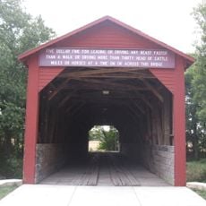
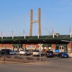
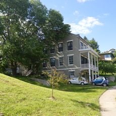
Cascade Bridge, Road bridge in Burlington, United States.

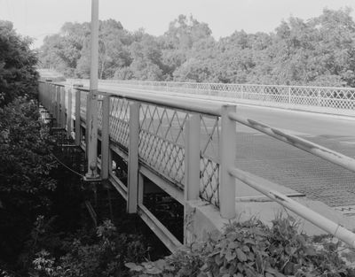
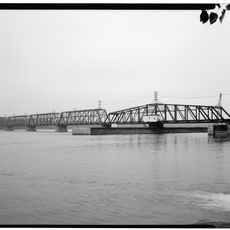
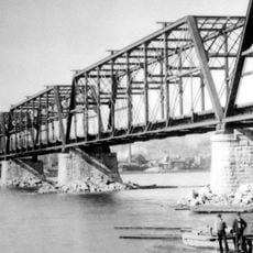
Cascade Bridge is a road crossing that spans a deep ravine using four equal steel sections joined together. The structure showcases multiple engineering design methods typical of the industrial age.

The bridge was approved by the city in 1896 and designed by a Cedar Rapids engineering firm, then built by manufacturers from Milwaukee. Over time, parts of the structure were replaced and reinforced, but its original framework remained intact.

The bridge takes its name from the deep ravine it crosses, and its steel structure remains visible from the surrounding landscape. Today visitors can admire the engineering design from outside, even though the structure no longer serves traffic.

The bridge has been closed to public use since 2008 and cannot be accessed by vehicles, pedestrians, or bicycles. The best way to view the structure is from the adjacent riverbanks or surrounding landscape.

The structure was added to the National Register of Historic Places in 1998, recognizing its importance to engineering history of the late 19th century. This acknowledgment reflects how the design methods used here represent a key moment in bridge-building techniques of that era.

The community of curious travelers

AroundUs brings together thousands of curated places, local tips, and hidden gems, enriched daily by 60,000 contributors worldwide.

Start exploring
Location
GPS coordinates
40.78111,-91.09833
Latest update
December 14, 2025 16:44
Around this place
Great River Bridge
United States of America

Great River Bridge

3.4 km
Community Field
United States of America

Community Field

6.1 km
Burlington Rail Bridge
United States of America

Burlington Rail Bridge

2 km
Crapo Park
United States of America

Crapo Park

662 m
Lock and Dam No. 18
United States of America

Lock and Dam No. 18

12.8 km
St. Paul's Catholic Church
United States of America

St. Paul's Catholic Church

3.5 km
First Congregational Church
United States of America

First Congregational Church

3.3 km
Capitol Theater
United States of America

Capitol Theater

3.2 km
German Methodist Episcopal Church
United States of America

German Methodist Episcopal Church

3.5 km
Des Moines County Court House
United States of America

Des Moines County Court House

3.4 km
Burlington Public Library
United States of America

Burlington Public Library

3.5 km
Oquawka Wagon Bridge
United States of America

Oquawka Wagon Bridge

17.8 km
South Henderson Church
United States of America

South Henderson Church

18.6 km
Heritage Hill Historic District
United States of America

Heritage Hill Historic District

3.6 km
Christ Episcopal Church
United States of America

Christ Episcopal Church

3.7 km
Snake Alley Historic District
United States of America

Snake Alley Historic District

3.5 km
Daniel McConn Barn
United States of America

Daniel McConn Barn

20.7 km
Downtown Commercial Historic District
United States of America

Downtown Commercial Historic District

3.2 km
Augustus Caesar Dodge House
United States of America

Augustus Caesar Dodge House

3.9 km
Henderson County Courthouse
United States of America

Henderson County Courthouse

21.1 km
Mary Darwin House
United States of America

Mary Darwin House

2.6 km
West Jefferson Street Historic District
United States of America

West Jefferson Street Historic District

3.4 km
Jagger-Churchill House
United States of America

Jagger-Churchill House

3.8 km
James M. Forney House
United States of America

James M. Forney House

2.2 km
Starker–Leopold Historic District
United States of America

Starker–Leopold Historic District

1.6 km
Abiathar and Nancy White House
United States of America

Abiathar and Nancy White House

3.7 km
Burlington Rail Bridge (1893)
United States of America

Burlington Rail Bridge (1893)

2 km
Burlington Rail Bridge (1867)
United States of America

Burlington Rail Bridge (1867)

2 km
Show the full map
« Cascade Bridge - Road bridge in Burlington, United States » is provided by Around Us (aroundus.com). Images and texts are derived from Wikimedia project under a Creative Commons license. You are allowed to copy, distribute, and modify copies of this page, under the conditions set by the license, as long as this note is clearly visible.

Discover hidden gems everywhere you go!

From secret cafés to breathtaking viewpoints, skip the crowded tourist spots and find places that match your style. Our app makes it easy with voice search, smart filtering, route optimization, and insider tips from travelers worldwide. Download now for the complete mobile experience.

Around Us App Screenshot

A unique approach to discovering new places

Le Figaro

All the places worth exploring

France Info

A tailor-made excursion in just a few clicks

20 Minutes

Around Us
Travel Guide & Maps
Download

Send to your phone

QR Code
1

Open the camera app on your mobile.

2

Point at the QR code with your camera. A notification will appear.

3

Tap the notification to open the link.