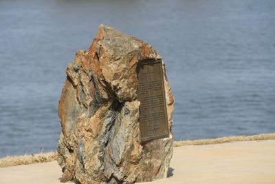
The Little Rock, Rock formation in Arkansas, US.
The Little Rock is a sandstone outcrop that extends into the Arkansas River, creating a visible natural feature in the landscape. The formation sits at the point where the Ouachita Mountains transition into the river floodplain to the south.
A French explorer documented this formation in 1722 and named it 'le Petit Rocher' on maps from the late 1700s. The location later gained recognition as a historic site due to its role as a significant landmark during the region's early development.
The rock formation served as a territorial marker for indigenous peoples, defining boundaries and creating a recognizable reference point in the landscape. This geographical role made it a place of practical and cultural importance to those who inhabited the region.
The site sits directly along the Arkansas River and can be easily viewed from the water or from nearby shoreline areas. Keep in mind that the rock formation is part of the river system and may appear different depending on the water level.
The rock consists of marine deposits from 320 million years ago, showing how dramatically the landscape has changed over time. This geological history makes the site a window into a prehistoric time long before rivers and people shaped the region.
The community of curious travelers
AroundUs brings together thousands of curated places, local tips, and hidden gems, enriched daily by 60,000 contributors worldwide.