Enable Location

We need your location to show you interesting places around you

Discover nearby places

Find interesting locations and hidden gems around you

Precise directions

Get accurate directions and distances to places

Your location is never shared with other users. It's only used when you tap the location button.

Creamery Covered Bridge

Log in to your account

Start exploring — it's free

Trusted by 62,462 travelers worldwide

Continue with Google
Continue with Apple
or

We will send you a code to connect

By continuing, you accept our Terms and Conditions and our Privacy Policy

Check your inbox

We've sent a pincode in your inbox. Please enter the code below.

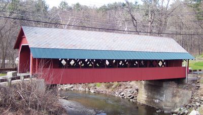
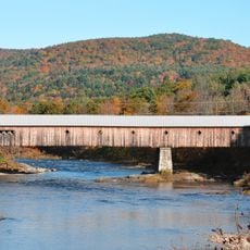
Creamery Covered Bridge, Historic covered bridge in West Brattleboro, United States.

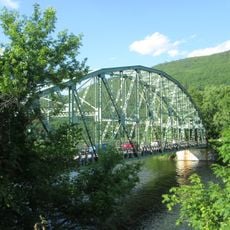
The Creamery Covered Bridge is a covered pedestrian structure spanning Whetstone Brook west of Brattleboro, constructed using the lattice truss design with spruce timber. The roof is covered in slate and the wooden sides are painted a traditional red color.

The bridge was built in 1879 following floods that destroyed an earlier crossing, serving farmers who needed to transport milk to local processing facilities. Its design using the Town lattice system was already proven as a reliable method for building sturdy river crossings.

The bridge takes its name from a nearby creamery that once processed milk from local dairy farms, reflecting the agricultural character of the area when it was built.

The bridge is located roughly 2 kilometers west of downtown Brattleboro near Route 9 and is easy to reach on foot. Since it is open only to pedestrians and cyclists, you can explore it without vehicle traffic.

The structure features unusual lateral bracing with guy wires on the upstream side, which provides extra stability against sideways forces from water movement. This reinforcement is characteristic of bridges exposed to strong currents or seasonal flooding.

The community of curious travelers

AroundUs brings together thousands of curated places, local tips, and hidden gems, enriched daily by 60,000 contributors worldwide.

Start exploring
Location
Inception
1879
Architectural style
lattice truss bridge
Made from material
spruce
GPS coordinates
42.84944,-72.58667
Latest update
December 13, 2025 11:42
Around this place
Naulakha
United States of America

Naulakha

5.8 km
Fort Dummer
United States of America

Fort Dummer

3.6 km
West Dummerston Covered Bridge
United States of America

West Dummerston Covered Bridge

10 km
United States Navy Seabees Bridge
United States of America

United States Navy Seabees Bridge

4.8 km
Brooks Memorial Library
United States of America

Brooks Memorial Library

2.3 km
Brattleboro Museum and Art Center
United States of America

Brattleboro Museum and Art Center

2.5 km
Latchis Hotel and Theatre
United States of America

Latchis Hotel and Theatre

2.4 km
Deacon John Holbrook House
United States of America

Deacon John Holbrook House

2.2 km
Rice Farm Road Bridge
United States of America

Rice Farm Road Bridge

7.7 km
William Harris House
United States of America

William Harris House

149 m
Brattleboro Downtown Historic District
United States of America

Brattleboro Downtown Historic District

2.3 km
Canal Street–Clark Street Neighborhood Historic District
United States of America

Canal Street–Clark Street Neighborhood Historic District

2.2 km
Todd Block
United States of America

Todd Block

10.4 km
Lewis Grout House
United States of America

Lewis Grout House

1.2 km
Guilford Center Meetinghouse
United States of America

Guilford Center Meetinghouse

7.1 km
Arthur D. and Emma J. Wyatt House
United States of America

Arthur D. and Emma J. Wyatt House

2.5 km
Dickinson Estate Historic District
United States of America

Dickinson Estate Historic District

4.9 km
Governor Hunt House
United States of America

Governor Hunt House

10 km
Tontine Building
United States of America

Tontine Building

2.8 km
West Brattleboro Green Historic District
United States of America

West Brattleboro Green Historic District

1.1 km
Homestead-Horton Neighborhood Historic District
United States of America

Homestead-Horton Neighborhood Historic District

2.1 km
Brattleboro Museum and Art Center
United States of America

Brattleboro Museum and Art Center

2.5 km
Madame Sherri's Castle
United States of America

Madame Sherri's Castle

5.7 km
B&M Connecticut River Bridge
United States of America

B&M Connecticut River Bridge

3.5 km
Municipal Center
United States of America

Municipal Center

2.2 km
Charles Dana Bridge
United States of America

Charles Dana Bridge

2.9 km
Anna Hunt Marsh Bridge
United States of America

Anna Hunt Marsh Bridge

2.6 km
Brattleboro Suspension Bridge
United States of America

Brattleboro Suspension Bridge

4.6 km
Show the full map
« Creamery Covered Bridge - Historic covered bridge in West Brattleboro, United States » is provided by Around Us (aroundus.com). Images and texts are derived from Wikimedia project under a Creative Commons license. You are allowed to copy, distribute, and modify copies of this page, under the conditions set by the license, as long as this note is clearly visible.

Discover hidden gems everywhere you go!

From secret cafés to breathtaking viewpoints, skip the crowded tourist spots and find places that match your style. Our app makes it easy with voice search, smart filtering, route optimization, and insider tips from travelers worldwide. Download now for the complete mobile experience.

Around Us App Screenshot

A unique approach to discovering new places

Le Figaro

All the places worth exploring

France Info

A tailor-made excursion in just a few clicks

20 Minutes

Around Us
Travel Guide & Maps
Download

Send to your phone

QR Code
1

Open the camera app on your mobile.

2

Point at the QR code with your camera. A notification will appear.

3

Tap the notification to open the link.