Enable Location

We need your location to show you interesting places around you

Discover nearby places

Find interesting locations and hidden gems around you

Precise directions

Get accurate directions and distances to places

Your location is never shared with other users. It's only used when you tap the location button.

West Dummerston Covered Bridge

Log in to your account

Start exploring — it's free

Trusted by 61,899 travelers worldwide

Continue with Google
Continue with Apple
or

We will send you a code to connect

By continuing, you accept our Terms and Conditions and our Privacy Policy

Check your inbox

We've sent a pincode in your inbox. Please enter the code below.

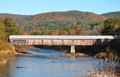
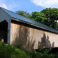
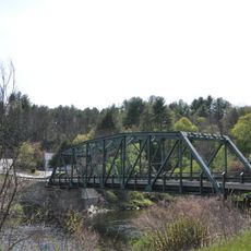
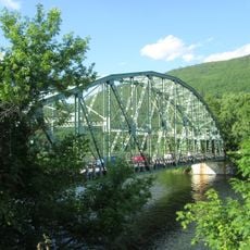
West Dummerston Covered Bridge, Covered road bridge in Dummerston, Vermont.

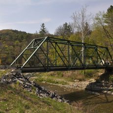
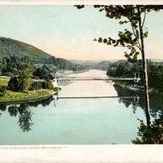
The West Dummerston Covered Bridge is a timber structure crossing the West River, built with Town lattice trusses and featuring diamond-shaped openings in its wooden walls. The bridge rests on stone abutments and a central pier that support its wooden frame today.

The bridge was built in 1872 by master builder Caleb Lamson and holds the distinction of being the longest covered bridge situated entirely within Vermont. It represents an era when wooden bridges served as vital crossing points over rivers throughout the region.

The National Register of Historic Places recognized this structure in 1973 for its representation of 19th-century American transportation engineering.

The bridge sits between Vermont Route 30 and Camp Arden Road and remains open to vehicle traffic. Visitors should be aware this is an active crossing, so exercise caution when exploring or photographing.

The diamond-shaped wall openings allow natural light to filter into the structure and illuminate the wooden interior during daylight. This deliberate design choice serves both functional and visual purposes for those passing through.

The community of curious travelers

AroundUs brings together thousands of curated places, local tips, and hidden gems, enriched daily by 60,000 contributors worldwide.

Start exploring
Location
GPS coordinates
42.93667,-72.61361
Latest update
December 12, 2025 12:03
Around this place
Naulakha
United States of America

Naulakha

5.8 km
United States Navy Seabees Bridge
United States of America

United States Navy Seabees Bridge

7.7 km
Creamery Covered Bridge
United States of America

Creamery Covered Bridge

10 km
Brooks Memorial Library
United States of America

Brooks Memorial Library

10.1 km
Brattleboro Museum and Art Center
United States of America

Brattleboro Museum and Art Center

10.6 km
Latchis Hotel and Theatre
United States of America

Latchis Hotel and Theatre

10.5 km
Round Schoolhouse
United States of America

Round Schoolhouse

9.5 km
Sacketts Brook Stone Arch Bridge
United States of America

Sacketts Brook Stone Arch Bridge

8.9 km
Williamsville Covered Bridge
United States of America

Williamsville Covered Bridge

6.1 km
Deacon John Holbrook House
United States of America

Deacon John Holbrook House

9.9 km
Putney Village Historic District
United States of America

Putney Village Historic District

8.4 km
Rice Farm Road Bridge
United States of America

Rice Farm Road Bridge

2.3 km
William Harris House
United States of America

William Harris House

9.9 km
Historical Society of Windham County
United States of America

Historical Society of Windham County

6.3 km
Brattleboro Downtown Historic District
United States of America

Brattleboro Downtown Historic District

10.2 km
Lewis Grout House
United States of America

Lewis Grout House

9.3 km
Theophilus Crawford House
United States of America

Theophilus Crawford House

9.3 km
Arthur D. and Emma J. Wyatt House
United States of America

Arthur D. and Emma J. Wyatt House

9.8 km
Dickinson Estate Historic District
United States of America

Dickinson Estate Historic District

6.4 km
Brookline-Newfane Bridge
United States of America

Brookline-Newfane Bridge

7 km
South Newfane Bridge
United States of America

South Newfane Bridge

7.4 km
Brookline Baptist Church
United States of America

Brookline Baptist Church

8.7 km
West Brattleboro Green Historic District
United States of America

West Brattleboro Green Historic District

9.4 km
Sabin-Wheat Farm
United States of America

Sabin-Wheat Farm

9.6 km
Municipal Center
United States of America

Municipal Center

10 km
Anna Hunt Marsh Bridge
United States of America

Anna Hunt Marsh Bridge

10.6 km
Brattleboro Suspension Bridge
United States of America

Brattleboro Suspension Bridge

7.9 km
Newfane Village Historic District
United States of America

Newfane Village Historic District

6.7 km
Show the full map
« West Dummerston Covered Bridge - Covered road bridge in Dummerston, Vermont » is provided by Around Us (aroundus.com). Images and texts are derived from Wikimedia project under a Creative Commons license. You are allowed to copy, distribute, and modify copies of this page, under the conditions set by the license, as long as this note is clearly visible.

Discover hidden gems everywhere you go!

From secret cafés to breathtaking viewpoints, skip the crowded tourist spots and find places that match your style. Our app makes it easy with voice search, smart filtering, route optimization, and insider tips from travelers worldwide. Download now for the complete mobile experience.

Around Us App Screenshot

A unique approach to discovering new places

Le Figaro

All the places worth exploring

France Info

A tailor-made excursion in just a few clicks

20 Minutes

Around Us
Travel Guide & Maps
Download

Send to your phone

QR Code
1

Open the camera app on your mobile.

2

Point at the QR code with your camera. A notification will appear.

3

Tap the notification to open the link.