Enable Location

We need your location to show you interesting places around you

Discover nearby places

Find interesting locations and hidden gems around you

Precise directions

Get accurate directions and distances to places

Your location is never shared with other users. It's only used when you tap the location button.

Williamsville Covered Bridge

Log in to your account

Start exploring — it's free

Trusted by 62,441 travelers worldwide

Continue with Google
Continue with Apple
or

We will send you a code to connect

By continuing, you accept our Terms and Conditions and our Privacy Policy

Check your inbox

We've sent a pincode in your inbox. Please enter the code below.

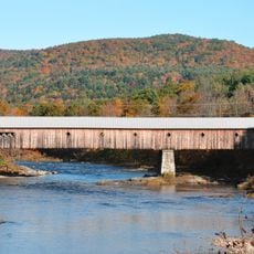
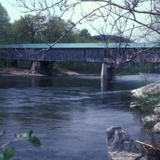
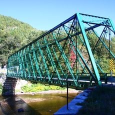
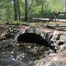
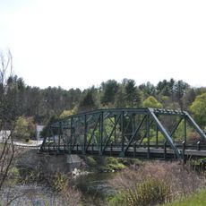
Williamsville Covered Bridge, historic covered bridge, carrying Dover Road over the Rock River in Newfane, Vermont

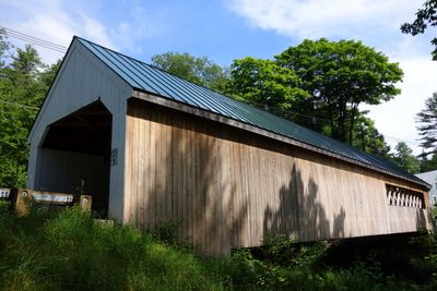
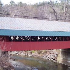
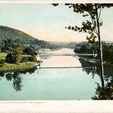
The Williamsville Covered Bridge is a wooden structure spanning the Rock River with a lattice truss design that measures approximately 118 feet in length. The original wooden support beams remain intact, while the interior roadway has been updated with steel beams and pavement, and the roof is protected by corrugated metal sheets.

The bridge was constructed in the 1870s and is likely the oldest of its kind in the Windham County region. In 2010, the original structure was replaced with a new replica that matches its appearance, ensuring both preservation of its historic character and modern functionality.

The bridge takes its name from the nearby village of Williamsville and has become a local landmark that connects residents across the Rock River. It remains the only covered bridge in Newfane and holds a special place in the town's identity and memory.

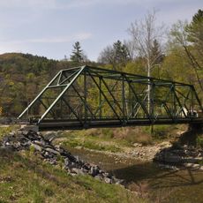
The bridge has a single traffic lane with small rectangular openings in the siding to help drivers see when approaching from either direction. The interior clearance is approximately 11 feet high, which means oversized vehicles or tall loads may not fit through safely.

Small rectangular window openings punctuate the bridge's wooden sides to give drivers better visibility when entering from either end. This practical design choice from the original construction shows how builders solved the safety challenge of passing through a dark enclosed wooden structure.

The community of curious travelers

AroundUs brings together thousands of curated places, local tips, and hidden gems, enriched daily by 60,000 contributors worldwide.

Start exploring
Location
GPS coordinates
42.94278,-72.68806
Latest update
February 9, 2026 07:43
Around this place
Naulakha
United States of America

Naulakha

11.2 km
Hogback Mountain
United States of America

Hogback Mountain

11.7 km
West Dummerston Covered Bridge
United States of America

West Dummerston Covered Bridge

6.1 km
United States Navy Seabees Bridge
United States of America

United States Navy Seabees Bridge

12.9 km
Creamery Covered Bridge
United States of America

Creamery Covered Bridge

13.3 km
Scott Covered Bridge
United States of America

Scott Covered Bridge

11.7 km
Round Schoolhouse
United States of America

Round Schoolhouse

11.1 km
Townshend State Park
United States of America

Townshend State Park

10.9 km
Deacon John Holbrook House
United States of America

Deacon John Holbrook House

14.1 km
Dover Town Hall
United States of America

Dover Town Hall

9.3 km
Putney Village Historic District
United States of America

Putney Village Historic District

13.8 km
Rice Farm Road Bridge
United States of America

Rice Farm Road Bridge

6.8 km
Southern Vermont Natural History Museum
United States of America

Southern Vermont Natural History Museum

13.1 km
William Harris House
United States of America

William Harris House

13.1 km
Historical Society of Windham County
United States of America

Historical Society of Windham County

5.3 km
First Congregational Church and Meetinghouse
United States of America

First Congregational Church and Meetinghouse

11.7 km
Follett Stone Arch Bridge Historic District
United States of America

Follett Stone Arch Bridge Historic District

11.8 km
Theophilus Crawford House
United States of America

Theophilus Crawford House

13.8 km
Lewis Grout House
United States of America

Lewis Grout House

12.2 km
Dickinson Estate Historic District
United States of America

Dickinson Estate Historic District

11.4 km
Brookline-Newfane Bridge
United States of America

Brookline-Newfane Bridge

7.3 km
South Newfane Bridge
United States of America

South Newfane Bridge

1.5 km
Wheelock House
United States of America

Wheelock House

10.3 km
Brookline Baptist Church
United States of America

Brookline Baptist Church

10.4 km
West Brattleboro Green Historic District
United States of America

West Brattleboro Green Historic District

12.4 km
Corse-Shippee House
United States of America

Corse-Shippee House

13 km
Brattleboro Suspension Bridge
United States of America

Brattleboro Suspension Bridge

13 km
Newfane Village Historic District
United States of America

Newfane Village Historic District

5.6 km
Show the full map
« Williamsville Covered Bridge - historic covered bridge, carrying Dover Road over the Rock River in Newfane, Vermont » is provided by Around Us (aroundus.com). Images and texts are derived from Wikimedia project under a Creative Commons license. You are allowed to copy, distribute, and modify copies of this page, under the conditions set by the license, as long as this note is clearly visible.

Discover hidden gems everywhere you go!

From secret cafés to breathtaking viewpoints, skip the crowded tourist spots and find places that match your style. Our app makes it easy with voice search, smart filtering, route optimization, and insider tips from travelers worldwide. Download now for the complete mobile experience.

Around Us App Screenshot

A unique approach to discovering new places

Le Figaro

All the places worth exploring

France Info

A tailor-made excursion in just a few clicks

20 Minutes

Around Us
Travel Guide & Maps
Download

Send to your phone

QR Code
1

Open the camera app on your mobile.

2

Point at the QR code with your camera. A notification will appear.

3

Tap the notification to open the link.