Enable Location

We need your location to show you interesting places around you

Discover nearby places

Find interesting locations and hidden gems around you

Precise directions

Get accurate directions and distances to places

Your location is never shared with other users. It's only used when you tap the location button.

Scott Covered Bridge

Log in to your account

Start exploring — it's free

Trusted by 61,892 travelers worldwide

Continue with Google
Continue with Apple
or

We will send you a code to connect

By continuing, you accept our Terms and Conditions and our Privacy Policy

Check your inbox

We've sent a pincode in your inbox. Please enter the code below.

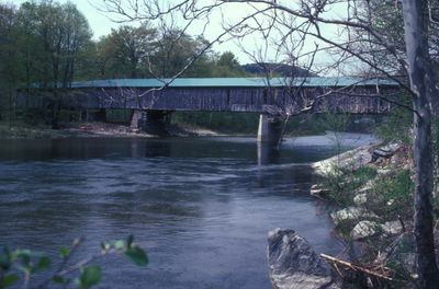
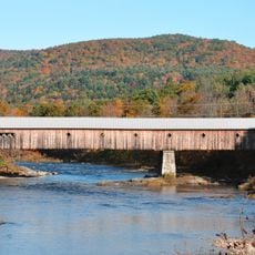
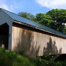
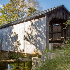
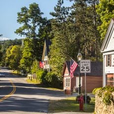
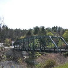
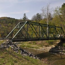
Scott Covered Bridge, Covered bridge in Townshend, US

The Scott Covered Bridge is a wooden structure spanning 277 feet (84 meters) across the West River. It employs three distinct support systems: Town lattice truss, kingpost trusses, and laminated arches working together.

It was built in 1870 as a crossing for the West River valley. The structure was reinforced over time with concrete foundations in 1915 and additional support beams added in 1961.

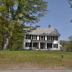
The bridge embodies rural New England construction methods and shows how communities once solved the problem of crossing rivers. It reflects the practical building traditions that defined the region for generations.

The bridge welcomes both pedestrians and cyclists and is accessible from Vermont Route 30. A major restoration was completed in 2017, so the structure is in good condition for visitors today.

It combines three different engineering systems within one structure, which was an experimental approach in the 1870s. This blend of techniques makes it stand out among similar bridges from that era.

The community of curious travelers

AroundUs brings together thousands of curated places, local tips, and hidden gems, enriched daily by 60,000 contributors worldwide.

Start exploring
Location
GPS coordinates
43.04806,-72.69722
Latest update
December 14, 2025 12:20
Around this place
West Dummerston Covered Bridge
United States of America

West Dummerston Covered Bridge

14.1 km
Jamaica State Park
United States of America

Jamaica State Park

8.9 km
Round Schoolhouse
United States of America

Round Schoolhouse

8.1 km
Townshend State Park
United States of America

Townshend State Park

888 m
Williamsville Covered Bridge
United States of America

Williamsville Covered Bridge

11.7 km
Dover Town Hall
United States of America

Dover Town Hall

14.4 km
West Townshend Stone Arch Bridge
United States of America

West Townshend Stone Arch Bridge

4.2 km
Kidder Covered Bridge
United States of America

Kidder Covered Bridge

15.4 km
Historical Society of Windham County
United States of America

Historical Society of Windham County

7.9 km
First Congregational Church and Meetinghouse
United States of America

First Congregational Church and Meetinghouse

2.3 km
Old Brick Church
United States of America

Old Brick Church

12.8 km
Follett Stone Arch Bridge Historic District
United States of America

Follett Stone Arch Bridge Historic District

993 m
Windham Village Historic District
United States of America

Windham Village Historic District

14.6 km
Theophilus Crawford House
United States of America

Theophilus Crawford House

14.1 km
Grafton Public Library
United States of America

Grafton Public Library

15.8 km
Grafton Village Historic District
United States of America

Grafton Village Historic District

15.6 km
Brookline-Newfane Bridge
United States of America

Brookline-Newfane Bridge

7.4 km
South Newfane Bridge
United States of America

South Newfane Bridge

12.3 km
Wheelock House
United States of America

Wheelock House

3.2 km
Mechanicsville Historic District
United States of America

Mechanicsville Historic District

15.8 km
Simpsonville Stone Arch Bridge
United States of America

Simpsonville Stone Arch Bridge

4.2 km
Brookline Baptist Church
United States of America

Brookline Baptist Church

8.2 km
Sabin-Wheat Farm
United States of America

Sabin-Wheat Farm

14.5 km
Milldean and Alexander-Davis House
United States of America

Milldean and Alexander-Davis House

15.6 km
South Windham Village Historic District
United States of America

South Windham Village Historic District

9 km
Hamilton Falls
United States of America

Hamilton Falls

11.2 km
West Townshend Village Historic District
United States of America

West Townshend Village Historic District

4.2 km
Newfane Village Historic District
United States of America

Newfane Village Historic District

7.5 km
Show the full map
« Scott Covered Bridge - Covered bridge in Townshend, US » is provided by Around Us (aroundus.com). Images and texts are derived from Wikimedia project under a Creative Commons license. You are allowed to copy, distribute, and modify copies of this page, under the conditions set by the license, as long as this note is clearly visible.

Discover hidden gems everywhere you go!

From secret cafés to breathtaking viewpoints, skip the crowded tourist spots and find places that match your style. Our app makes it easy with voice search, smart filtering, route optimization, and insider tips from travelers worldwide. Download now for the complete mobile experience.

Around Us App Screenshot

A unique approach to discovering new places

Le Figaro

All the places worth exploring

France Info

A tailor-made excursion in just a few clicks

20 Minutes

Around Us
Travel Guide & Maps
Download

Send to your phone

QR Code
1

Open the camera app on your mobile.

2

Point at the QR code with your camera. A notification will appear.

3

Tap the notification to open the link.