Enable Location

We need your location to show you interesting places around you

Discover nearby places

Find interesting locations and hidden gems around you

Precise directions

Get accurate directions and distances to places

Your location is never shared with other users. It's only used when you tap the location button.

Round Schoolhouse

Log in to your account

Start exploring — it's free

Trusted by 61,899 travelers worldwide

Continue with Google
Continue with Apple
or

We will send you a code to connect

By continuing, you accept our Terms and Conditions and our Privacy Policy

Check your inbox

We've sent a pincode in your inbox. Please enter the code below.

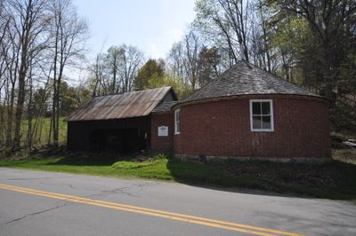
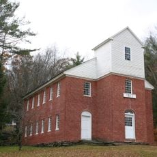
Round Schoolhouse, Historic brick schoolhouse in Brookline, Vermont

The Round Schoolhouse is a one-story circular brick building in Brookline with five windows arranged around its perimeter and a shallow conical roof. The structure relies on an iron hoop system beneath the roof to support its distinctive round shape.

Built in 1822 by Scottish immigrant John Wilson, it is the oldest brick schoolhouse in Windham County and operated as a school for more than a century. The structure was later repurposed for other community needs after its educational role ended.

The building reflects teaching methods from the early 1800s, when students learned in an open circular space under one teacher's supervision. This design allowed education to happen in a single shared room without separate classrooms.

Located on Grassy Brook Road, the building is visible from the road and its distinctive round shape can be appreciated from the exterior. Access may be limited since it now serves as a historical monument, so plan to view it primarily from outside.

After closing as a school in 1929, the building served as Brookline's town hall until 1989. This second life as a civic center demonstrates how the community valued and reused this historic structure.

The community of curious travelers

AroundUs brings together thousands of curated places, local tips, and hidden gems, enriched daily by 60,000 contributors worldwide.

Start exploring
Location
Inception
1822
Address
Grassy Brook Road
GPS coordinates
43.02139,-72.60472
Latest update
December 14, 2025 18:14
Around this place
Naulakha
United States of America

Naulakha

14.1 km
United States of America

Westminster massacre

12.9 km
West Dummerston Covered Bridge
United States of America

West Dummerston Covered Bridge

9.5 km
Scott Covered Bridge
United States of America

Scott Covered Bridge

8.1 km
Townshend State Park
United States of America

Townshend State Park

7.5 km
Sacketts Brook Stone Arch Bridge
United States of America

Sacketts Brook Stone Arch Bridge

8.8 km
Williamsville Covered Bridge
United States of America

Williamsville Covered Bridge

11.1 km
Putney Village Historic District
United States of America

Putney Village Historic District

8.3 km
Rice Farm Road Bridge
United States of America

Rice Farm Road Bridge

11.7 km
Park Hill Meetinghouse
United States of America

Park Hill Meetinghouse

13.1 km
West Townshend Stone Arch Bridge
United States of America

West Townshend Stone Arch Bridge

11.1 km
Historical Society of Windham County
United States of America

Historical Society of Windham County

5.8 km
First Congregational Church and Meetinghouse
United States of America

First Congregational Church and Meetinghouse

6 km
East Putney Brook Stone Arch Bridge
United States of America

East Putney Brook Stone Arch Bridge

11.7 km
Old Brick Church
United States of America

Old Brick Church

11.5 km
Follett Stone Arch Bridge Historic District
United States of America

Follett Stone Arch Bridge Historic District

9 km
Theophilus Crawford House
United States of America

Theophilus Crawford House

6.1 km
Dickinson Estate Historic District
United States of America

Dickinson Estate Historic District

14.8 km
Brookline-Newfane Bridge
United States of America

Brookline-Newfane Bridge

3.8 km
South Newfane Bridge
United States of America

South Newfane Bridge

12.4 km
Wheelock House
United States of America

Wheelock House

5 km
Simpsonville Stone Arch Bridge
United States of America

Simpsonville Stone Arch Bridge

6.8 km
Brookline Baptist Church
United States of America

Brookline Baptist Church

746 m
Sabin-Wheat Farm
United States of America

Sabin-Wheat Farm

6.4 km
South Windham Village Historic District
United States of America

South Windham Village Historic District

14.8 km
Westminster Village Historic District
United States of America

Westminster Village Historic District

12.7 km
West Townshend Village Historic District
United States of America

West Townshend Village Historic District

11.1 km
Newfane Village Historic District
United States of America

Newfane Village Historic District

5.7 km
Show the full map
« Round Schoolhouse - Historic brick schoolhouse in Brookline, Vermont » is provided by Around Us (aroundus.com). Images and texts are derived from Wikimedia project under a Creative Commons license. You are allowed to copy, distribute, and modify copies of this page, under the conditions set by the license, as long as this note is clearly visible.

Discover hidden gems everywhere you go!

From secret cafés to breathtaking viewpoints, skip the crowded tourist spots and find places that match your style. Our app makes it easy with voice search, smart filtering, route optimization, and insider tips from travelers worldwide. Download now for the complete mobile experience.

Around Us App Screenshot

A unique approach to discovering new places

Le Figaro

All the places worth exploring

France Info

A tailor-made excursion in just a few clicks

20 Minutes

Around Us
Travel Guide & Maps
Download

Send to your phone

QR Code
1

Open the camera app on your mobile.

2

Point at the QR code with your camera. A notification will appear.

3

Tap the notification to open the link.