Hogback Mountain

Log in to your account

AroundUs is a community-driven map of interesting places, built by curious explorers like you. It grows with every review, story, and photo you share.
Connect to save your favorite spots, contribute locations, and create personalized routes.
Continue with Google
Continue with Apple
Continue with X
Continue with Facebook
Continue with email
By continuing, you accept our Terms and Conditions and our Privacy Policy
Create an account
Add to collection
Map
Suggest a change
Share

Hogback Mountain, Mountain summit in Marlboro, United States.

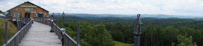
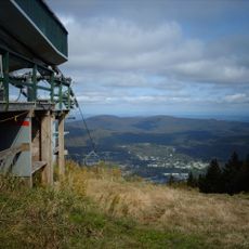
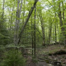
Hogback Mountain is a summit near Marlboro that reaches 2,409 feet and features a mix of wooded slopes and rocky terrain across its walking routes. The trails wind through 590 acres of protected land managed as a conservation area where visitors encounter varied natural environments throughout their visit.

A ski area operated on the mountain from 1946 until 1986, offering local students free weekly skiing before rising insurance expenses led to its closure. This period marked the mountain's shift from recreational development to its current role as a conservation and education space.

The Hogback Mountain Conservation Area maintains a network of trails through 590 acres of protected land, supporting outdoor recreation and environmental education.

The mountain can be reached via Vermont Route 9, where parking areas provide access to maintained trails suited for various fitness levels. Bring appropriate hiking gear and be cautious during wet or icy conditions, as rocky sections can become slippery.

The mountain hosts a bird-banding research project that collects data on spring and fall songbird migrations, contributing to nationwide scientific databases. Visitors may occasionally observe researchers in action during peak migration seasons.

Location: Marlboro

GPS coordinates: 42.86703,-72.78760

Latest update: December 10, 2025 20:07

Photos
Around this place
Mount Snow
United States of America

Mount Snow

15.1 km
Naulakha
United States of America

Naulakha

18.6 km
United States of America

Haystack Mountain

11.9 km
West Dummerston Covered Bridge
United States of America

West Dummerston Covered Bridge

16.2 km
Creamery Covered Bridge
United States of America

Creamery Covered Bridge

16.5 km
Brooks Memorial Library
United States of America

Brooks Memorial Library

18.6 km
Molly Stark State Park
United States of America

Molly Stark State Park

2.6 km
Green River Covered Bridge
United States of America

Green River Covered Bridge

14.1 km
Williamsville Covered Bridge
United States of America

Williamsville Covered Bridge

11.7 km
Deacon John Holbrook House
United States of America

Deacon John Holbrook House

18.4 km
Dover Town Hall
United States of America

Dover Town Hall

8.7 km
Medburyville Bridge
United States of America

Medburyville Bridge

10.8 km
Rice Farm Road Bridge
United States of America

Rice Farm Road Bridge

15.2 km
Southern Vermont Natural History Museum
United States of America

Southern Vermont Natural History Museum

1.6 km
William Harris House
United States of America

William Harris House

16.4 km
Whitingham Village Historic District
United States of America

Whitingham Village Historic District

11.4 km
Wilmington Village Historic District
United States of America

Wilmington Village Historic District

7.1 km
Historical Society of Windham County
United States of America

Historical Society of Windham County

16.9 km
Lewis Grout House
United States of America

Lewis Grout House

15.3 km
Guilford Center Meetinghouse
United States of America

Guilford Center Meetinghouse

15.6 km
Dickinson Estate Historic District
United States of America

Dickinson Estate Historic District

18.2 km
South Newfane Bridge
United States of America

South Newfane Bridge

10.4 km
Tontine Building
United States of America

Tontine Building

17.9 km
West Brattleboro Green Historic District
United States of America

West Brattleboro Green Historic District

15.4 km
Corse-Shippee House
United States of America

Corse-Shippee House

9.1 km
Homestead-Horton Neighborhood Historic District
United States of America

Homestead-Horton Neighborhood Historic District

18.6 km
Municipal Center
United States of America

Municipal Center

18.6 km
Newfane Village Historic District
United States of America

Newfane Village Historic District

17.1 km
Show the full map
Reviews

Visited this place? Tap the stars to rate it and share your experience / photos with the community! Try now! You can cancel it anytime.

« Hogback Mountain - Mountain summit in Marlboro, United States » is provided by Around Us (aroundus.com). Images and texts are derived from Wikimedia project under a Creative Commons license. You are allowed to copy, distribute, and modify copies of this page, under the conditions set by the license, as long as this note is clearly visible.

Discover hidden gems everywhere you go!

From secret cafés to breathtaking viewpoints, skip the crowded tourist spots and find places that match your style. Our app makes it easy with voice search, smart filtering, route optimization, and insider tips from travelers worldwide. Download now for the complete mobile experience.

Around Us App Screenshot

A unique approach to discovering new places

Le Figaro

All the places worth exploring

France Info

A tailor-made excursion in just a few clicks

20 Minutes