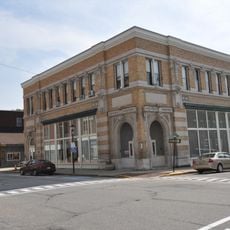
Strathglass Building
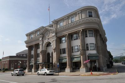
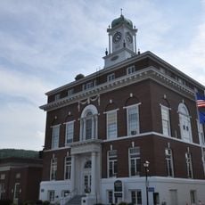
The Strathglass Building is a four-story brick structure in downtown Rumford standing on a corner lot with buildings flanking three sides. The lower floors feature tall windows separated by stone columns, with a main entrance framed by a large arched opening topped by a triangular pediment.
Built around 1900 in the Beaux-Arts style, the structure originally had three floors with a decorative roof balustrade topped by urns. After a fire in 1931, it was rebuilt with a fourth floor added and an ornate lobby featuring Italian Renaissance-inspired details, while the load-bearing stone walls were preserved.
The building takes its name from a Scottish river, chosen by local industrialist Hugh J. Chisholm who commissioned it after lands near his family's estate. A worker housing district in Rumford shares the same name, linking this structure to the town's industrial workforce and community.
The building sits prominently on a downtown corner lot in Rumford, making it easy to locate and view from multiple street angles. Its central position provides convenient pedestrian access and good visibility from surrounding streets.
The building was overseen by Frank Bunker Gilbreth, a notable local builder, with designs by architects from Providence, Rhode Island. The ornate Italian Renaissance-inspired lobby added after the 1931 fire survives intact today, revealing the craftsmanship invested in its reconstruction.
The community of curious travelers
AroundUs brings together thousands of curated places, local tips, and hidden gems, enriched daily by 60,000 contributors worldwide.