Enable Location

We need your location to show you interesting places around you

Discover nearby places

Find interesting locations and hidden gems around you

Precise directions

Get accurate directions and distances to places

Your location is never shared with other users. It's only used when you tap the location button.

Sunday River Bridge

Log in to your account

Start exploring — it's free

Trusted by 62,992 travelers worldwide

Continue with Google
Continue with Apple
or

We will send you a code to connect

By continuing, you accept our Terms and Conditions and our Privacy Policy

Check your inbox

We've sent a pincode in your inbox. Please enter the code below.

Discussion Reviews 1 Photos
1.6k Popularity

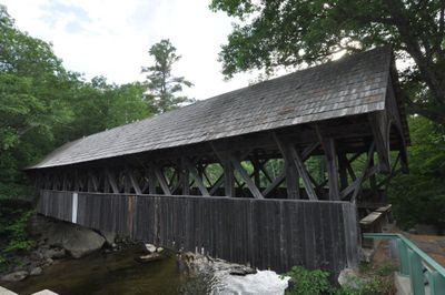
Sunday River Bridge, Covered bridge in Oxford County, Maine, US.

Sunday River Bridge is a covered wooden crossing with red exterior walls that spans the river in Oxford County. The structure features granite supports and a peaked roof that protects the wooden interior from weather.

The present structure was built in 1872 after two earlier bridges were destroyed by flooding in 1869 and 1871. The rebuilt crossing used reinforced building methods to better withstand river conditions.

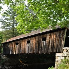
The bridge displays 19th-century craftsmanship through its wooden construction and red exterior that shapes the local landscape today. Walking through it gives visitors a direct sense of how builders worked during that era.

Access has been limited to foot traffic since 1955, with vehicle traffic redirected to a newer bridge nearby. This quiet setting lets you visit the historic structure without dealing with cars passing through.

The wooden shingle roof and vertical interior boards are original to the structure and show craftsmanship details from the 1800s. These preserved materials make it a rare example of building techniques that have largely disappeared elsewhere.

The community of curious travelers

AroundUs brings together thousands of curated places, local tips, and hidden gems, enriched daily by 60,000 contributors worldwide.

Start exploring
Location
Inception
1872
GPS coordinates
44.49190,-70.84330
Latest update
December 14, 2025 14:27
Around this place
Old Speck Mountain
United States of America

Old Speck Mountain

12.5 km
Grafton Notch State Park
United States of America

Grafton Notch State Park

14 km
United States of America

Baldpate Mountain

13.6 km
Goose Eye Mountain
United States of America

Goose Eye Mountain

12.5 km
Merrill-Poor House
United States of America

Merrill-Poor House

18 km
Andover Public Library
United States of America

Andover Public Library

17.2 km
North Waterford Congregational Church
United States of America

North Waterford Congregational Church

24 km
Congregational Church
United States of America

Congregational Church

26.1 km
Lovejoy Bridge
United States of America

Lovejoy Bridge

14.3 km
Rumford Public Library
United States of America

Rumford Public Library

24.1 km
Gehring Clinic
United States of America

Gehring Clinic

11.2 km
Meadow Bridge
United States of America

Meadow Bridge

20.3 km
Albany Town House
United States of America

Albany Town House

19.6 km
Hall House
United States of America

Hall House

10.5 km
Dr. Moses Mason House
United States of America

Dr. Moses Mason House

10.5 km
Rumford Municipal Building
United States of America

Rumford Municipal Building

24.3 km
Middle Intervale Meeting House and Common
United States of America

Middle Intervale Meeting House and Common

5.5 km
Rumford Falls Power Company Building
United States of America

Rumford Falls Power Company Building

24.3 km
John M. Philbrook House
United States of America

John M. Philbrook House

10.5 km
Former Greenwood Town Hall
United States of America

Former Greenwood Town Hall

14.9 km
Whitman Memorial Library
United States of America

Whitman Memorial Library

20.2 km
Lower Meeting House and East Bethel Cemetery
United States of America

Lower Meeting House and East Bethel Cemetery

10.1 km
Deacon Hutchins House
United States of America

Deacon Hutchins House

13.2 km
Greenwood Cattle Pound
United States of America

Greenwood Cattle Pound

24.1 km
Lower Sunday River School
United States of America

Lower Sunday River School

2.4 km
Samuel D. Philbrook House
United States of America

Samuel D. Philbrook House

10.1 km
Rumford Falls
United States of America

Rumford Falls

24.4 km
Screw Auger Falls
United States of America

Screw Auger Falls

10 km
Show the full map
Reviews
Share your experience

No review yet

Discussions
Start a discussion...

No discussion yet

« Sunday River Bridge - Covered bridge in Oxford County, Maine, US » is provided by Around Us (aroundus.com). Images and texts are derived from Wikimedia project under a Creative Commons license. You are allowed to copy, distribute, and modify copies of this page, under the conditions set by the license, as long as this note is clearly visible.

Discover hidden gems everywhere you go!

From secret cafés to breathtaking viewpoints, skip the crowded tourist spots and find places that match your style. Our app makes it easy with voice search, smart filtering, route optimization, and insider tips from travelers worldwide. Download now for the complete mobile experience.

Around Us App Screenshot

A unique approach to discovering new places

Le Figaro

All the places worth exploring

France Info

A tailor-made excursion in just a few clicks

20 Minutes

Around Us
Travel Guide & Maps
Download

Send to your phone

QR Code
1

Open the camera app on your mobile.

2

Point at the QR code with your camera. A notification will appear.

3

Tap the notification to open the link.