Grafton Notch State Park

Log in to your account

AroundUs is a community-driven map of interesting places, built by curious explorers like you. It grows with every review, story, and photo you share.
Connect to save your favorite spots, contribute locations, and create personalized routes.
Continue with Google
Continue with Apple
Continue with X
Continue with Facebook
Continue with email
By continuing, you accept our Terms and Conditions and our Privacy Policy
Create an account

Grafton Notch State Park

Add to collection
Map
Suggest a change
Share

Grafton Notch State Park, State park in western Maine, United States.

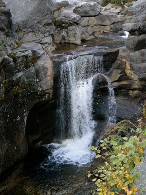
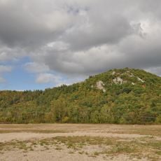
Grafton Notch State Park is a natural area covering more than 3000 acres in western Maine with several mountain peaks, waterfalls including Screw Auger Falls, and dramatic rocky terrain. The Appalachian Trail passes through the park, guiding hikers through forests and over rock formations that define the landscape.

The valley served as a travel route for Native peoples long before the area received official protection as a state park in 1963. This designation marked the start of organized conservation efforts in the region.

The park functions as a place where visitors can experience and learn about local natural systems firsthand. Rangers offer regular programs about geology, wildlife, and conservation that help explain how the landscape formed and continues to change.

Multiple parking areas are located near trailheads, waterfalls, and picnic spots throughout the park for easy access to different attractions. Trails receive winter maintenance, which makes snow sports and winter hiking possible during colder months.

Exposed bedrock throughout the park dates back to the Devonian period more than 400 million years ago and reveals metamorphic rocks shaped by ancient glaciers. These geological features tell the story of deep time visible in the stone itself.

Location: Maine

Inception: 1963

Website: https://apps.web.maine.gov/cgi-bin/online/doc/parksearch/details.pl?park_id=1

GPS coordinates: 44.59339,-70.94785

Latest update: December 10, 2025 20:01

Photos
Around this place
Old Speck Mountain
United States of America

Old Speck Mountain

2.6 km
Holy Resurrection Orthodox Church
United States of America

Holy Resurrection Orthodox Church

23.8 km
United States of America

Baldpate Mountain

4.6 km
St. Anne Church
United States of America

St. Anne Church

22.7 km
Goose Eye Mountain
United States of America

Goose Eye Mountain

10.9 km
Forest Lodge
United States of America

Forest Lodge

19.3 km
Umbagog Lake State Park
United States of America

Umbagog Lake State Park

14.8 km
Mount Jasper Lithic Source
United States of America

Mount Jasper Lithic Source

23 km
Sunday River Bridge
United States of America

Sunday River Bridge

14 km
Mollidgewock State Park
United States of America

Mollidgewock State Park

22.5 km
Merrill-Poor House
United States of America

Merrill-Poor House

17.2 km
Andover Public Library
United States of America

Andover Public Library

16.1 km
United States of America

Milan Hill State Park

22 km
Congregational Church
United States of America

Congregational Church

21.9 km
Lovejoy Bridge
United States of America

Lovejoy Bridge

17 km
Meadow Bridge
United States of America

Meadow Bridge

23.1 km
Dr. Moses Mason House
United States of America

Dr. Moses Mason House

24.3 km
Middle Intervale Meeting House and Common
United States of America

Middle Intervale Meeting House and Common

19.3 km
John M. Philbrook House
United States of America

John M. Philbrook House

24.3 km
Lower Meeting House and East Bethel Cemetery
United States of America

Lower Meeting House and East Bethel Cemetery

23 km
Saint Anne Historic District
United States of America

Saint Anne Historic District

22.5 km
Deacon Hutchins House
United States of America

Deacon Hutchins House

20.7 km
Lower Sunday River School
United States of America

Lower Sunday River School

16.3 km
Samuel D. Philbrook House
United States of America

Samuel D. Philbrook House

24 km
Princess Theatre
United States of America

Princess Theatre

23.3 km
Albert Theater
United States of America

Albert Theater

22.9 km
Screw Auger Falls
United States of America

Screw Auger Falls

4.4 km
Pontook Reservoir
United States of America

Pontook Reservoir

24.2 km
Show the full map
Reviews

Visited this place? Tap the stars to rate it and share your experience / photos with the community! Try now! You can cancel it anytime.

« Grafton Notch State Park - State park in western Maine, United States » is provided by Around Us (aroundus.com). Images and texts are derived from Wikimedia project under a Creative Commons license. You are allowed to copy, distribute, and modify copies of this page, under the conditions set by the license, as long as this note is clearly visible.

Discover hidden gems everywhere you go!

From secret cafés to breathtaking viewpoints, skip the crowded tourist spots and find places that match your style. Our app makes it easy with voice search, smart filtering, route optimization, and insider tips from travelers worldwide. Download now for the complete mobile experience.

Around Us App Screenshot

A unique approach to discovering new places

Le Figaro

All the places worth exploring

France Info

A tailor-made excursion in just a few clicks

20 Minutes