Lincoln Highway in Greene County, Iowa, Historic highway section in Greene County, United States
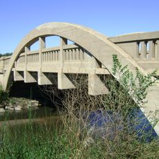
The Lincoln Highway through Greene County is a historic road section displaying multiple road types, from paved sections to preserved early routes and original bridges. The pathway crosses the county's landscape and retains various structures like culverts and drainage systems built during the highway's active period.
Established in 1913, the highway was the first transcontinental automobile route connecting New York City to San Francisco. Over subsequent decades it was largely replaced by newer roads, but sections in Greene County still display the original construction methods and materials from that pioneering era.
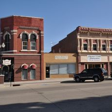
The highway became a symbol of travel freedom and progress across America, with communities along the route building their own identities as places on a major journey corridor. You still see this in how Jefferson's buildings and businesses face the road, reflecting the days when this path carried regular traffic and visitors through town.
Visitors can explore different segments along dirt and paved portions to see varying construction styles from different periods. Plan time for walking or driving along the route to examine the bridges and older structures scattered throughout the area.
The abandoned Buttrick's Creek segment preserves its original 1920 condition, showing how early road builders laid curves and built up layers for durability. This unaltered state makes it a rare example of actual construction techniques from the pioneering road-building era.
The community of curious travelers
AroundUs brings together thousands of curated places, local tips, and hidden gems, enriched daily by 60,000 contributors worldwide.