Enable Location

We need your location to show you interesting places around you

Discover nearby places

Find interesting locations and hidden gems around you

Precise directions

Get accurate directions and distances to places

Your location is never shared with other users. It's only used when you tap the location button.

Packhouse Ford

Log in to your account

Start exploring — it's free

Trusted by 63,612 travelers worldwide

Continue with Google
Continue with Apple
or

We will send you a code to connect

By continuing, you accept our Terms and Conditions and our Privacy Policy

Check your inbox

We've sent a pincode in your inbox. Please enter the code below.

Discussion Reviews 1 Photos
1.2k Popularity

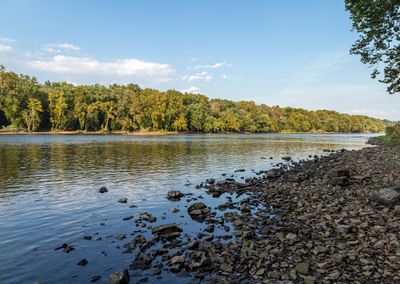
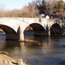
Packhouse Ford, historic crossing point of the Potomac River

Packhouse Ford is a historic river crossing over the Potomac located about a mile east of Shepherdstown in Washington County. The site displays worn paths and stones that mark centuries of foot traffic and wagon wheels crossing from one riverbank to the other.

Native Americans first used this crossing as a travel route, later developed by colonial settlers and traders into a busy passage point. During the American Civil War, soldiers moved across the ford during military campaigns, particularly near the Battle of Antietam, and the site received official recognition on the National Register of Historic Places in 2015.

Packhouse Ford served as a vital crossing point where Native Americans, settlers, and traders regularly met to exchange goods and move across the river. The site reflects how this ford became a gathering place that connected different communities and shaped daily life in the area.

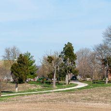
A marker on the West Virginia side indicates the historic crossing at the junction of River Road and Trough Road. The area remains quiet and natural, making it suitable for a straightforward walk along the riverbank to experience the site and its surroundings firsthand.

The site is also known by alternate names such as Blackford's Ford and Boteler's Ford, reflecting the different groups who used it throughout history. These alternative names reveal layers of the crossing's story tied to specific families and travelers who passed through.

The community of curious travelers

AroundUs brings together thousands of curated places, local tips, and hidden gems, enriched daily by 60,000 contributors worldwide.

Start exploring
GPS coordinates
39.42972,-77.77819
Latest update
February 9, 2026 07:45
Around this place
Burnside's Bridge
United States of America

Burnside's Bridge

4.6 km
Antietam Creek
United States of America

Antietam Creek

3.1 km
James Rumsey Monument
United States of America

James Rumsey Monument

1.8 km
Shepherdstown Historic District
United States of America

Shepherdstown Historic District

2.5 km
Ram Stadium
United States of America

Ram Stadium

2.4 km
Conrad Shindler House
United States of America

Conrad Shindler House

2.4 km
The American Volunteer
United States of America

The American Volunteer

4.6 km
Van Swearingen-Shepherd House
United States of America

Van Swearingen-Shepherd House

2.5 km
Captain William Lucas and Robert Lucas House
United States of America

Captain William Lucas and Robert Lucas House

3.1 km
Antietam National Cemetery
United States of America

Antietam National Cemetery

4.6 km
Morgan's Grove
United States of America

Morgan's Grove

3.2 km
Antietam Iron Furnace Site and Antietam Village
United States of America

Antietam Iron Furnace Site and Antietam Village

3.4 km
Falling Spring-Morgan's Grove
United States of America

Falling Spring-Morgan's Grove

3.3 km
Shepherd's Mill
United States of America

Shepherd's Mill

2 km
Morgan-Bedinger-Dandridge House
United States of America

Morgan-Bedinger-Dandridge House

2.9 km
Mount Airy
United States of America

Mount Airy

2.3 km
Piper House
United States of America

Piper House

4.3 km
Jacob Highbarger House
United States of America

Jacob Highbarger House

3.9 km
Tolson's Chapel and School
United States of America

Tolson's Chapel and School

4 km
Sharpsburg Historic District
United States of America

Sharpsburg Historic District

4 km
William Chapline House
United States of America

William Chapline House

4.1 km
Good-Reilly House
United States of America

Good-Reilly House

4.1 km
Joseph C. Hays House
United States of America

Joseph C. Hays House

4 km
Norfolk Southern Potomac River Bridge
United States of America

Norfolk Southern Potomac River Bridge

1.7 km
Potomac River Bridge
United States of America

Potomac River Bridge

2.2 km
C&O Canal Antietam Creek Aqueduct
United States of America

C&O Canal Antietam Creek Aqueduct

3.1 km
Potomac River Bridge
United States of America

Potomac River Bridge

2.2 km
Antietam Ironworks Bridge
United States of America

Antietam Ironworks Bridge

3.4 km
Show the full map
Reviews
Share your experience

No review yet

Discussions
Start a discussion...

No discussion yet

« Packhouse Ford - historic crossing point of the Potomac River » is provided by Around Us (aroundus.com). Images and texts are derived from Wikimedia project under a Creative Commons license. You are allowed to copy, distribute, and modify copies of this page, under the conditions set by the license, as long as this note is clearly visible.

Discover hidden gems everywhere you go!

From secret cafés to breathtaking viewpoints, skip the crowded tourist spots and find places that match your style. Our app makes it easy with voice search, smart filtering, route optimization, and insider tips from travelers worldwide. Download now for the complete mobile experience.

Around Us App Screenshot

A unique approach to discovering new places

Le Figaro

All the places worth exploring

France Info

A tailor-made excursion in just a few clicks

20 Minutes

Around Us
Travel Guide & Maps
Download

Send to your phone

QR Code
1

Open the camera app on your mobile.

2

Point at the QR code with your camera. A notification will appear.

3

Tap the notification to open the link.