Enable Location

We need your location to show you interesting places around you

Discover nearby places

Find interesting locations and hidden gems around you

Precise directions

Get accurate directions and distances to places

Your location is never shared with other users. It's only used when you tap the location button.

Mayfield Cemetery

Log in to your account

Start exploring — it's free

Trusted by 62,556 travelers worldwide

Continue with Google
Continue with Apple
or

We will send you a code to connect

By continuing, you accept our Terms and Conditions and our Privacy Policy

Check your inbox

We've sent a pincode in your inbox. Please enter the code below.

Mayfield Cemetery

Mayfield Cemetery, Rural and Jewish cemetery in Cleveland Heights, United States

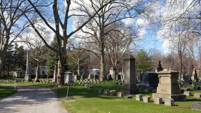
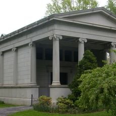
Mayfield Cemetery is a 21-acre burial ground in Cleveland Heights containing approximately 12,000 graves marked with marble monuments. The space is divided into maintained sections by paved pathways, and includes a mausoleum building with a chapel.

The cemetery was established in 1887 when a religious congregation purchased the land to serve as a burial ground for the Jewish population on Cleveland's east side. At that time, the location was still beyond the city's boundaries.

The cemetery serves as the burial ground for members of two major Reform congregations in the area, with its maintained sections reflecting the traditions and values of these communities. The organized landscape shows how the place holds meaning for families across generations.

The cemetery is located on Mayfield Road with good access and clearly marked pathways throughout. Visitors interested in family history can find burial records through local genealogical resources.

The grounds represent the only Jewish garden cemetery in Cuyahoga County and hold the burial site of a notable religious leader in its southwest section. This combination of historical significance and rare design sets it apart from other burial places in the area.

The community of curious travelers

AroundUs brings together thousands of curated places, local tips, and hidden gems, enriched daily by 60,000 contributors worldwide.

Start exploring
Inception
July 31, 1887
GPS coordinates
41.51386,-81.58228
Latest update
December 12, 2025 12:07
Around this place
Cleveland Museum of Natural History
United States of America

Cleveland Museum of Natural History

2.1 km
James A. Garfield Memorial
United States of America

James A. Garfield Memorial

872 m
Severance Hall
United States of America

Severance Hall

2.4 km
Forest Hill
United States of America

Forest Hill

1.9 km
Cleveland Botanical Garden
United States of America

Cleveland Botanical Garden

2.3 km
Museum of Contemporary Art Cleveland
United States of America

Museum of Contemporary Art Cleveland

2 km
Crawford Auto-Aviation Museum
United States of America

Crawford Auto-Aviation Museum

2.4 km
Wade Memorial Chapel
United States of America

Wade Memorial Chapel

1.1 km
Park Synagogue
United States of America

Park Synagogue

1.7 km
Wade Park
United States of America

Wade Park

2.4 km
Forest Hill Park
United States of America

Forest Hill Park

1 km
Dittrick Museum of Medical History
United States of America

Dittrick Museum of Medical History

2.4 km
Adelbert Hall
United States of America

Adelbert Hall

2.4 km
Allen Memorial Medical Library
United States of America

Allen Memorial Medical Library

2.4 km
Stadium Square Historic District
United States of America

Stadium Square Historic District

2.2 km
First Church of Christ, Scientist
United States of America

First Church of Christ, Scientist

1.9 km
Flora Stone Mather College Historic District
United States of America

Flora Stone Mather College Historic District

2.2 km
Cozad-Bates House
United States of America

Cozad-Bates House

1.9 km
Euclid Golf Allotment
United States of America

Euclid Golf Allotment

1.9 km
St. Paul's Episcopal Church
United States of America

St. Paul's Episcopal Church

2.3 km
Fairmount Boulevard District
United States of America

Fairmount Boulevard District

2.3 km
Alta Public Library
United States of America

Alta Public Library

1.3 km
Peter B. Lewis Building
United States of America

Peter B. Lewis Building

2.2 km
Mather House
United States of America

Mather House

2.2 km
Mayfield Theater
United States of America

Mayfield Theater

1.4 km
Madstone Centrum
United States of America

Madstone Centrum

659 m
The Michelson-Morley Experiment
United States of America

The Michelson-Morley Experiment

2.3 km
Coventry Branch Library
United States of America

Coventry Branch Library

757 m
Show the full map
« Mayfield Cemetery - Rural and Jewish cemetery in Cleveland Heights, United States » is provided by Around Us (aroundus.com). Images and texts are derived from Wikimedia project under a Creative Commons license. You are allowed to copy, distribute, and modify copies of this page, under the conditions set by the license, as long as this note is clearly visible.

Discover hidden gems everywhere you go!

From secret cafés to breathtaking viewpoints, skip the crowded tourist spots and find places that match your style. Our app makes it easy with voice search, smart filtering, route optimization, and insider tips from travelers worldwide. Download now for the complete mobile experience.

Around Us App Screenshot

A unique approach to discovering new places

Le Figaro

All the places worth exploring

France Info

A tailor-made excursion in just a few clicks

20 Minutes

Around Us
Travel Guide & Maps
Download

Send to your phone

QR Code
1

Open the camera app on your mobile.

2

Point at the QR code with your camera. A notification will appear.

3

Tap the notification to open the link.