Enable Location

We need your location to show you interesting places around you

Discover nearby places

Find interesting locations and hidden gems around you

Precise directions

Get accurate directions and distances to places

Your location is never shared with other users. It's only used when you tap the location button.

Log in to your account

Start exploring — it's free

Trusted by 62,057 travelers worldwide

Continue with Google
Continue with Apple
or

We will send you a code to connect

By continuing, you accept our Terms and Conditions and our Privacy Policy

Check your inbox

We've sent a pincode in your inbox. Please enter the code below.

West Malpais Wilderness

West Malpais Wilderness, Volcanic wilderness area in New Mexico, US.

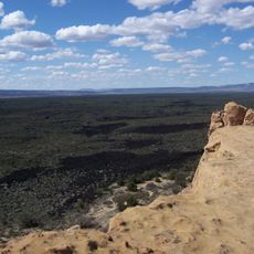
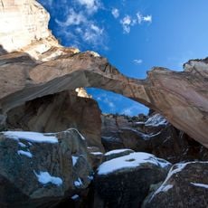
West Malpais Wilderness is a protected area in New Mexico featuring expansive volcanic terrain shaped by ancient lava flows. The landscape transitions between open grasslands, pinon-juniper forests, and ponderosa pine zones across different elevations.

Congress established this area as protected wilderness in 1987 as part of the El Malpais National Conservation Area. This designation recognized the geological significance of the volcanic landscape and secured its future conservation.

The Continental Divide National Scenic Trail crosses through the southern section, offering hikers opportunities to traverse this geological formation.

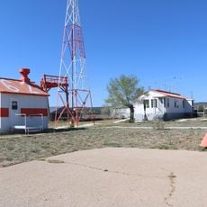
A backcountry permit is required to enter the area and can be obtained from the El Malpais Information Center in Grants or the BLM ranger station on State Road 117. Access points are available in both the northern and southern sections of the wilderness.

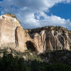
The Hole-in-the-Wall kipuka in the northern section is an isolated grassland plateau surrounded by jagged lava rock. This natural enclosure offers a striking contrast to the surrounding volcanic terrain.

The community of curious travelers

AroundUs brings together thousands of curated places, local tips, and hidden gems, enriched daily by 60,000 contributors worldwide.

Start exploring
Location
GPS coordinates
34.89017,-108.15844
Latest update
December 14, 2025 14:22
Around this place
Mount Taylor
United States of America

Mount Taylor

63.4 km
The Lightning Field
United States of America

The Lightning Field

41.9 km
Fort Wingate
United States of America

Fort Wingate

73.1 km
Hawikuh Ruins
United States of America

Hawikuh Ruins

75.6 km
El Rancho Hotel & Motel
United States of America

El Rancho Hotel & Motel

88 km
Bandera Volcano Ice Cave
United States of America

Bandera Volcano Ice Cave

13.2 km
Bluewater Lake State Park
United States of America

Bluewater Lake State Park

45.2 km
Zuñi Salt Lake
United States of America

Zuñi Salt Lake

74.2 km
United States of America

Enchanted Mesa

55.6 km
El Malpais National Conservation Area
United States of America

El Malpais National Conservation Area

13 km
San Estevan Del Rey Mission Church
United States of America

San Estevan Del Rey Mission Church

52.6 km
United States of America

Dowa Yalanne

60.6 km
Cebolla Wilderness
United States of America

Cebolla Wilderness

26.8 km
Acoma Curio Shop
United States of America

Acoma Curio Shop

55.6 km
Datil-Mogollon Section
United States of America

Datil-Mogollon Section

54.2 km
Sacred Heart Cathedral
United States of America

Sacred Heart Cathedral

88.1 km
Grant meteorite
United States of America

Grant meteorite

41.4 km
Kin Ya-ah
United States of America

Kin Ya-ah

87.6 km
San Jose de la Laguna Mission and Convento
United States of America

San Jose de la Laguna Mission and Convento

72.1 km
Bowlin's Old Crater Trading Post
United States of America

Bowlin's Old Crater Trading Post

46.6 km
McKinley County Courthouse
United States of America

McKinley County Courthouse

88.3 km
Grants-Milan Flight Service Station
United States of America

Grants-Milan Flight Service Station

38.9 km
Chief Theatre
United States of America

Chief Theatre

88.6 km
Charley's Automotive Service
United States of America

Charley's Automotive Service

39.9 km
Redwood Lodge
United States of America

Redwood Lodge

88.2 km
Drake Hotel
United States of America

Drake Hotel

88.5 km
United States Post Office
United States of America

United States Post Office

88.5 km
Lebanon Lodge No. 22
United States of America

Lebanon Lodge No. 22

88.5 km
Show the full map
« West Malpais Wilderness - Volcanic wilderness area in New Mexico, US » is provided by Around Us (aroundus.com). Images and texts are derived from Wikimedia project under a Creative Commons license. You are allowed to copy, distribute, and modify copies of this page, under the conditions set by the license, as long as this note is clearly visible.

Discover hidden gems everywhere you go!

From secret cafés to breathtaking viewpoints, skip the crowded tourist spots and find places that match your style. Our app makes it easy with voice search, smart filtering, route optimization, and insider tips from travelers worldwide. Download now for the complete mobile experience.

Around Us App Screenshot

A unique approach to discovering new places

Le Figaro

All the places worth exploring

France Info

A tailor-made excursion in just a few clicks

20 Minutes

Around Us
Travel Guide & Maps
Download

Send to your phone

QR Code
1

Open the camera app on your mobile.

2

Point at the QR code with your camera. A notification will appear.

3

Tap the notification to open the link.