Enable Location

We need your location to show you interesting places around you

Discover nearby places

Find interesting locations and hidden gems around you

Precise directions

Get accurate directions and distances to places

Your location is never shared with other users. It's only used when you tap the location button.

Cebolla Wilderness

Log in to your account

Join the adventure

Create your free account and start exploring (like 60k+ others)

We will send you a code to connect

or
Continue with Google
Continue with Apple
By continuing, you accept our Terms and Conditions and our Privacy Policy

Check your inbox

We've sent a pincode in your inbox. Please enter the code below.

Cebolla Wilderness

Cebolla Wilderness, Wilderness area in New Mexico, United States

Description

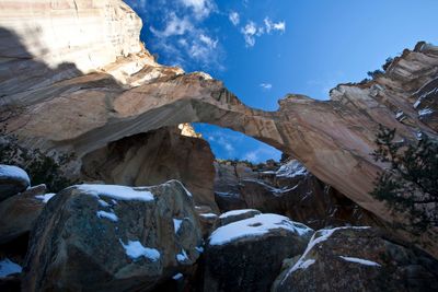
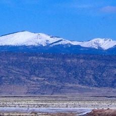
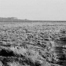
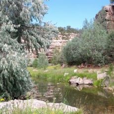
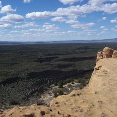
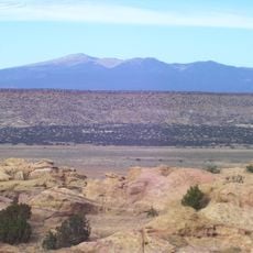
Cebolla Wilderness is a protected area in New Mexico covering 61,600 acres of sandstone formations, deep canyons, and grassy valleys. The terrain features striking vertical cliffs and open grasslands, with canyon systems that cut naturally through the landscape.

History

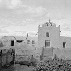
Between 1000 and 1300 AD, ancestors of today's Pueblo peoples built the Dittert Site, leaving traces of settlements throughout the region. This early occupation demonstrates that people lived and worked in these lands for centuries before modern times.

Culture

The sandstone walls throughout the area display numerous petroglyphs left by indigenous peoples, showing how these communities were connected to these lands. Visitors walking through can see these rock carvings as evidence of generations who lived and traveled here.

Practical

The area can be accessed via Highway 117, with multiple entry points throughout the conservation area. Visitors should prepare for changing weather and uneven terrain, bringing adequate water and sturdy footwear for hiking.

Did you know?

The vertical rock escarpments throughout the wilderness provide nesting sites for rare birds of prey including golden eagles, prairie falcons, and red-tailed hawks. These bird species use the vertical cliffs for breeding and hunting, making the area an important habitat for raptors.

Location
GPS coordinates
34.75000,-107.92000
Latest update
December 14, 2025 11:20

AroundUs brings together thousands of curated places, local tips, and hidden gems, enriched daily by 60,000 contributors worldwide. Discover all places nearby (New Mexico).

Around this place
Karl G. Jansky Very Large Array
United States of America

Karl G. Jansky Very Large Array

79.7 km
United States of America

Los Lunas Decalogue Stone

84.5 km
Mount Taylor
United States of America

Mount Taylor

61.4 km
The Lightning Field
United States of America

The Lightning Field

31.1 km
Very Long Baseline Array
United States of America

Very Long Baseline Array

79.7 km
Bandera Volcano Ice Cave
United States of America

Bandera Volcano Ice Cave

30.7 km
Bluewater Lake State Park
United States of America

Bluewater Lake State Park

63 km
United States of America

Enchanted Mesa

38.6 km
El Malpais National Conservation Area
United States of America

El Malpais National Conservation Area

15.2 km
San Estevan Del Rey Mission Church
United States of America

San Estevan Del Rey Mission Church

34.9 km
United States of America

Dowa Yalanne

86.5 km
Ladron Peak
United States of America

Ladron Peak

84.3 km
Acoma Curio Shop
United States of America

Acoma Curio Shop

47.4 km
Datil-Mogollon Section
United States of America

Datil-Mogollon Section

54 km
Grant meteorite
United States of America

Grant meteorite

45.2 km
San Jose de la Laguna Mission and Convento
United States of America

San Jose de la Laguna Mission and Convento

58 km
Bowlin's Old Crater Trading Post
United States of America

Bowlin's Old Crater Trading Post

59.8 km
Grants-Milan Flight Service Station
United States of America

Grants-Milan Flight Service Station

46.4 km
Hall Hotel
United States of America

Hall Hotel

94.1 km
Aragon House
United States of America

Aragon House

94 km
Roy T. Herman's Garage and Service Station
United States of America

Roy T. Herman's Garage and Service Station

77.2 km
Charley's Automotive Service
United States of America

Charley's Automotive Service

45.4 km
Bank of Magdalena
United States of America

Bank of Magdalena

93.9 km
MacTavish House
United States of America

MacTavish House

94.2 km
Ilfeld Warehouse
United States of America

Ilfeld Warehouse

93.8 km
Sky City Cultural Center and Haak'u Museum

Sky City Cultural Center and Haak'u Museum

34.8 km
Shiva:Shiwana
United States of America

Shiva:Shiwana

80 km
Bracewell Radio Sundial
United States of America

Bracewell Radio Sundial

80 km
Show the full map
« Cebolla Wilderness - Wilderness area in New Mexico, United States » is provided by Around Us (aroundus.com). Images and texts are derived from Wikimedia project under a Creative Commons license. You are allowed to copy, distribute, and modify copies of this page, under the conditions set by the license, as long as this note is clearly visible.

Discover hidden gems everywhere you go!

From secret cafés to breathtaking viewpoints, skip the crowded tourist spots and find places that match your style. Our app makes it easy with voice search, smart filtering, route optimization, and insider tips from travelers worldwide. Download now for the complete mobile experience.

Around Us App Screenshot

A unique approach to discovering new places

Le Figaro

All the places worth exploring

France Info

A tailor-made excursion in just a few clicks

20 Minutes

Around Us
Travel Guide & Maps
Download

Send to your phone

QR Code
1

Open the camera app on your mobile.

2

Point at the QR code with your camera. A notification will appear.

3

Tap the notification to open the link.