Enable Location

We need your location to show you interesting places around you

Discover nearby places

Find interesting locations and hidden gems around you

Precise directions

Get accurate directions and distances to places

Your location is never shared with other users. It's only used when you tap the location button.

Maidstone State Park

Log in to your account

Start exploring — it's free

Trusted by 61,867 travelers worldwide

Continue with Google
Continue with Apple
or

We will send you a code to connect

By continuing, you accept our Terms and Conditions and our Privacy Policy

Check your inbox

We've sent a pincode in your inbox. Please enter the code below.

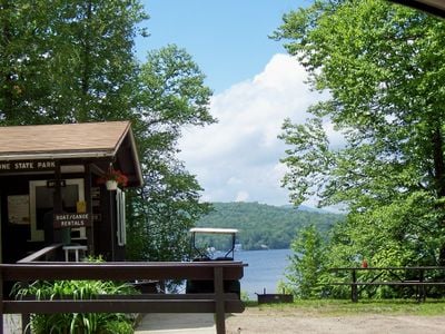
Maidstone State Park, State park on Maidstone Lake, Vermont, United States.

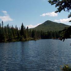
Maidstone State Park is a state park in Vermont centered on a 279-acre lake surrounded by mixed northern hardwood forest. The park provides multiple natural environments suited for various outdoor activities throughout the year.

The Vermont state government purchased the land in 1938 from the New Hampshire and Vermont Lumber Company to create a public recreation area. This acquisition transformed industrial land into a park open to all.

The park serves as a traditional outdoor recreation space where visitors engage in fishing, camping, swimming, and wildlife observation throughout the seasons. It remains an important place for people to spend leisure time connecting with nature in the Vermont landscape.

The park offers camping with tent sites and lean-to shelters, plus facilities including showers, flush toilets, and a picnic pavilion. Visitors should plan for a multi-day stay and expect it to be busy during peak season.

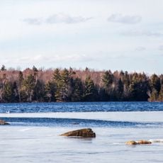
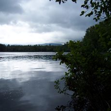
The lake supports a population of lake trout that thrive in its deep, cold waters. The water body formed around 12,000 years ago through glacial processes, giving it ecological character.

The community of curious travelers

AroundUs brings together thousands of curated places, local tips, and hidden gems, enriched daily by 60,000 contributors worldwide.

Start exploring
Location
Inception
1938
GPS coordinates
44.63870,-71.64340
Latest update
December 14, 2025 11:25
Around this place
Great North Woods Region
United States of America

Great North Woods Region

27.8 km
Santa's Village
United States of America

Santa's Village

26.4 km
Burke Mountain
United States of America

Burke Mountain

21.2 km
United States of America

Silvio O. Conte National Fish and Wildlife Refuge

15.2 km
Mount Orne Covered Bridge
United States of America

Mount Orne Covered Bridge

19.9 km
Janice Peaslee Bridge
United States of America

Janice Peaslee Bridge

6.6 km
Weeks Estate
United States of America

Weeks Estate

21.6 km
Brighton State Park
United States of America

Brighton State Park

24.4 km
The Horn
United States of America

The Horn

23.5 km
Stark Covered Bridge
United States of America

Stark Covered Bridge

19.1 km
Columbia Bridge
United States of America

Columbia Bridge

24.9 km
Burklyn Hall
United States of America

Burklyn Hall

26.1 km
Darling Estate Historic District
United States of America

Darling Estate Historic District

26.1 km
Waumbek Cottages Historic District
United States of America

Waumbek Cottages Historic District

28.3 km
Wilder-Holton House
United States of America

Wilder-Holton House

16 km
Wallace Farm
United States of America

Wallace Farm

26.9 km
Centre Covered Bridge
United States of America

Centre Covered Bridge

30.2 km
William Dennis Weeks Memorial Library
United States of America

William Dennis Weeks Memorial Library

17.4 km
Toll House
United States of America

Toll House

21.2 km
Bloomfield-Nulhegan River Route 102 Bridge
United States of America

Bloomfield-Nulhegan River Route 102 Bridge

12.7 km
Union Meeting House
United States of America

Union Meeting House

24.2 km
Martin Homestead
United States of America

Martin Homestead

15.2 km
Burrington Covered Bridge
United States of America

Burrington Covered Bridge

27.6 km
Guildhall Village Historic District
United States of America

Guildhall Village Historic District

10.4 km
Judge David Hibbard Homestead
United States of America

Judge David Hibbard Homestead

29 km
Island Pond Historic District
United States of America

Island Pond Historic District

27.2 km
Mechanic Street Bridge
United States of America

Mechanic Street Bridge

18 km
Groveton Bridge
United States of America

Groveton Bridge

11.6 km
Show the full map
« Maidstone State Park - State park on Maidstone Lake, Vermont, United States » is provided by Around Us (aroundus.com). Images and texts are derived from Wikimedia project under a Creative Commons license. You are allowed to copy, distribute, and modify copies of this page, under the conditions set by the license, as long as this note is clearly visible.

Discover hidden gems everywhere you go!

From secret cafés to breathtaking viewpoints, skip the crowded tourist spots and find places that match your style. Our app makes it easy with voice search, smart filtering, route optimization, and insider tips from travelers worldwide. Download now for the complete mobile experience.

Around Us App Screenshot

A unique approach to discovering new places

Le Figaro

All the places worth exploring

France Info

A tailor-made excursion in just a few clicks

20 Minutes

Around Us
Travel Guide & Maps
Download

Send to your phone

QR Code
1

Open the camera app on your mobile.

2

Point at the QR code with your camera. A notification will appear.

3

Tap the notification to open the link.