
Gorgol Region, region of Mauritania
Location: Mauritania
Capital city: Kaédi
Elevation above the sea: 20 m
GPS coordinates: 16.05000,-12.81667
Latest update: March 3, 2025 22:55

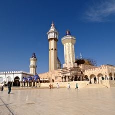
Great Mosque of Touba
352.8 km
Niokolo-Koba National Park
340.2 km
Djoudj National Bird Sanctuary
368.9 km
River Gambia National Park
353.8 km
MacCarthy Island
350 km
Gouina Falls
292 km
Félou Falls
246 km
Talari Gorges
321.3 km
Cercles de pierres de Wassu
342.4 km
Usine des eaux de Mbakhana
379.9 km
Deer Island (Gambia)
353.9 km
Isla Sepu
355.3 km
Tata of Koniakary
262.9 km
Isla Brikama
359.2 km
Bird Island
345.4 km
Eisenbahnbrücke von Kidira
188.7 km
Cercles de pierres de Kerbatch
354.8 km
Sankulay Kunda Bridge
350.7 km
Straßenbrücke von Kidira
189.3 km
Isla Pangon
348.9 km
Isla Pasari
294.6 km
Isla Ba Faraba
368.2 km
Mimang Island
356.5 km
Isla Njubou
373.4 km
Pappa Island
372.7 km
Little Pappa Island
374.6 km
Fort de Médine
242.7 km
Slave House
348.9 kmVisited this place? Tap the stars to rate it and share your experience / photos with the community! Try now! You can cancel it anytime.
Discover hidden gems everywhere you go!
From secret cafés to breathtaking viewpoints, skip the crowded tourist spots and find places that match your style. Our app makes it easy with voice search, smart filtering, route optimization, and insider tips from travelers worldwide. Download now for the complete mobile experience.

A unique approach to discovering new places❞
— Le Figaro
All the places worth exploring❞
— France Info
A tailor-made excursion in just a few clicks❞
— 20 Minutes