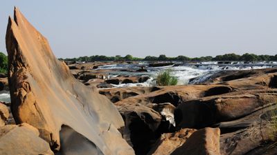
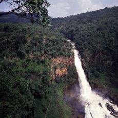
Félou Falls, Waterfall in Kayes Region, Mali.
Félou Falls extends roughly 1000 meters across the Senegal River, descending through multiple rocky steps as the water drops progressively. The cascade spreads widely across the riverbed, creating a layered waterfall rather than a single drop.
The area held strategic importance during colonial times, when European powers sought to control river trading routes in the 1850s. This early occupation shaped the region's development and connections for generations afterward.
The falls represent a gathering point for nearby communities, who have arranged their settlements and livelihoods around the river's flow. Local people have shaped their daily patterns based on this natural boundary.
The best time to visit is during the rainy season when water flow is strongest and the river crossing is accessible. It helps to check local conditions beforehand, as road and river access depend heavily on weather patterns.
A modern power station has channeled the waterfall's force into electricity generation for surrounding areas in recent years. This installation demonstrates how natural sites are adapted for contemporary energy needs.
Location: Kayes Region
Elevation above the sea: 34 m
Width: 1,000 m
Part of: Senegal River
GPS coordinates: 14.35639,-11.34528
Latest update: December 6, 2025 17:46
Mali's landscape tells stories through its buildings and nature. In cities like Timbuktu, Djenné, and Gao, you will find striking mud-brick structures that have stood for centuries. These are not just buildings—they are centers of learning, prayer, and daily life where communities have gathered for...
Niokolo-Koba National Park
237 kmBoucle du Baoulé National Park
267.4 km
River Gambia National Park
398.5 km
MacCarthy Island
380.8 km
Gouina Falls
46.2 km
Bassari Country
254.8 km
Badiar National Park
288.2 km
Dindefelo Falls
245.8 km
Mine de Siguiri
379 km
Lake Manantali
171.8 km
Talari Gorges
75.8 km
Stade Régional Saifoullaye Diallo
353.4 km
Cercles de pierres de Wassu
387.6 km
Kambadaga Falls
394.2 km
Isla Sepu
390.7 km
Tata of Koniakary
54.2 km
Bird Island
393.3 km
Eisenbahnbrücke von Kidira
93.6 km
Sankulay Kunda Bridge
380.9 km
Straßenbrücke von Kidira
93.4 km
Isla Pangon
382.7 km
Isla Pasari
304.3 km
Mimang Island
396.1 km
Simbalo
282.1 km
Fort de Médine
3.4 km
Arch of Kamandjan
393.3 km
Slave House
380.3 km
Chuttes de Sala
363.7 kmVisited this place? Tap the stars to rate it and share your experience / photos with the community! Try now! You can cancel it anytime.
Discover hidden gems everywhere you go!
From secret cafés to breathtaking viewpoints, skip the crowded tourist spots and find places that match your style. Our app makes it easy with voice search, smart filtering, route optimization, and insider tips from travelers worldwide. Download now for the complete mobile experience.
A unique approach to discovering new places❞
— Le Figaro
All the places worth exploring❞
— France Info
A tailor-made excursion in just a few clicks❞
— 20 Minutes