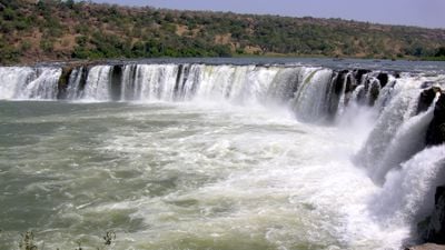
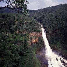
Gouina Falls, Waterfall on Senegal River, Kayes Region, Mali.
Gouina Falls is a wide cascade stretching about 430 meters across, dropping over granite rocks and creating a continuous display of rushing water. The falls descend in stages over the river's rocky bed, forming a dramatic shift in the water's movement as it flows downstream.
Plans to use this site for generating electricity emerged in the 1920s as Mali began exploring ways to develop its water resources. These early studies laid the groundwork for later thinking about energy projects in the region.
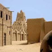
The place has been woven into the daily lives of nearby communities for generations, with people adapting their routines to the river's rhythm and seasonal changes. Their connection to this spot remains visible in how they use the surrounding land today.
The site is easier to approach during the dry season when water volume decreases and the surrounding ground becomes more accessible. During the rainy season, expect heavy water flow and more challenging conditions for getting close to the falls.
Over thousands of years, circular potholes about two meters deep have formed in the rock face above the falls, visible to visitors who explore the area. These natural pools demonstrate how persistent water flow gradually shapes stone through patient erosion.
Location: Kayes Region
Elevation above the sea: 64 m
Width: 430 m
Part of: Senegal River
GPS coordinates: 14.01500,-11.10250
Latest update: December 6, 2025 17:44
Mali's landscape tells stories through its buildings and nature. In cities like Timbuktu, Djenné, and Gao, you will find striking mud-brick structures that have stood for centuries. These are not just buildings—they are centers of learning, prayer, and daily life where communities have gathered for...
Niokolo-Koba National Park
237.7 kmBoucle du Baoulé National Park
239.8 km
Bassari Country
246.4 km
National Library of Mali
368.1 km
Badiar National Park
285.9 km
Dindefelo Falls
226.5 km
Félou Falls
46.2 km
Zoo Bamako
368.1 km
Mine de Siguiri
332.8 km
Lake Manantali
125.8 km
Museo Nacional
368.5 km
Talari Gorges
29.7 km
Stade Régional Saifoullaye Diallo
326.5 km
Kambadaga Falls
368.4 km
Tata of Koniakary
66.7 km
Eisenbahnbrücke von Kidira
129 km
Jardin du cinquantenaire
367.9 km
Straßenbrücke von Kidira
128.7 km
Isla Pasari
323.8 km
Monument of Independence
368.9 km
Monument de la paix
368.6 km
Simbalo
256.2 km
Peace Monument
368.6 km
Abdoul Karim Camara
365.6 km
Fort de Médine
49.4 km
Arch of Kamandjan
350.9 km
Chuttes de Sala
339.6 km
Monumento a la Independencia
368.9 kmVisited this place? Tap the stars to rate it and share your experience / photos with the community! Try now! You can cancel it anytime.
Discover hidden gems everywhere you go!
From secret cafés to breathtaking viewpoints, skip the crowded tourist spots and find places that match your style. Our app makes it easy with voice search, smart filtering, route optimization, and insider tips from travelers worldwide. Download now for the complete mobile experience.
A unique approach to discovering new places❞
— Le Figaro
All the places worth exploring❞
— France Info
A tailor-made excursion in just a few clicks❞
— 20 Minutes