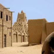
Fort de Médine, Colonial fortress in Kayes, Mali
Fort de Médine is a stone fortress in Kayes, Mali, positioned on elevated ground overlooking the Senegal River. The structure features high defensive walls, guard towers, and military buildings that command views across the river valley.
The fortress was built in the 1850s under the orders of a French governor as a strategic stronghold. It came under siege by a local army for several months, demonstrating its critical role in regional power struggles.
The fortress marks where French colonial forces and local communities intersected during a time of territorial change. Walking through it today shows how two different powers competed for control of this river region.
The fortress is open daily, and hiring a guide helps explain the military design and defensive layout. Wear sturdy shoes as the pathways can be uneven and the terrain is elevated.
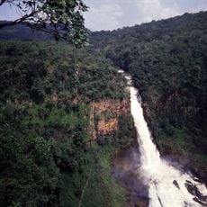
The fortress sits at the location where the Senegal River reaches its last major waterfall, making this the farthest point boats from the Atlantic coast could travel upstream. This geographic detail made the site invaluable for controlling river trade moving in either direction.
Location: Kayes
Address: 9JGJ+QPH, Mali
Opening Hours: Monday-Sunday 08:00-18:30
Phone: +22376267540
GPS coordinates: 14.37687,-11.36826
Latest update: December 6, 2025 19:06
Mali's landscape tells stories through its buildings and nature. In cities like Timbuktu, Djenné, and Gao, you will find striking mud-brick structures that have stood for centuries. These are not just buildings—they are centers of learning, prayer, and daily life where communities have gathered for...
Niokolo-Koba National Park
236.6 kmBoucle du Baoulé National Park
270.1 km
River Gambia National Park
396.5 km
MacCarthy Island
378.9 km
Gouina Falls
49.4 km
Bassari Country
254.9 km
Badiar National Park
287.9 km
Dindefelo Falls
246.8 km
Félou Falls
3.4 km
Mine de Siguiri
382.2 km
Lake Manantali
175.1 km
Talari Gorges
79 km
Stade Régional Saifoullaye Diallo
354.9 km
Cercles de pierres de Wassu
385.6 km
Kambadaga Falls
395.6 km
Isla Sepu
388.8 km
Tata of Koniakary
55.4 km
Bird Island
391.3 km
Eisenbahnbrücke von Kidira
90.9 km
Sankulay Kunda Bridge
379 km
Straßenbrücke von Kidira
90.6 km
Isla Pangon
380.8 km
Isla Pasari
302.5 km
Mimang Island
394.2 km
Simbalo
284.7 km
Arch of Kamandjan
396.6 km
Slave House
378.4 km
Chuttes de Sala
365 kmVisited this place? Tap the stars to rate it and share your experience / photos with the community! Try now! You can cancel it anytime.
Discover hidden gems everywhere you go!
From secret cafés to breathtaking viewpoints, skip the crowded tourist spots and find places that match your style. Our app makes it easy with voice search, smart filtering, route optimization, and insider tips from travelers worldwide. Download now for the complete mobile experience.
A unique approach to discovering new places❞
— Le Figaro
All the places worth exploring❞
— France Info
A tailor-made excursion in just a few clicks❞
— 20 Minutes