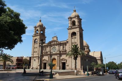
Tacna, Regional capital in southern Peru.
This place is the provincial capital of a Peruvian region near the border with Chile, about 35 kilometers from the neighboring country. It sits at 552 meters elevation in the Caplina River valley and extends between desert landscape and irrigated agricultural zones.
Administration switched to Chile in 1883 following the War of the Pacific and returned under Peruvian control only in 1929 through the Treaty of Lima. The decades under Chilean rule shaped the cityscape and its relations with the border region.
The name of this border city derives from words meaning "four rivers" in the language of native peoples, a reference to waterways that once converged here. Today residents use the squares and streets for gatherings and trade with visitors from the neighboring country.
The Crnl. FAP. Carlos Ciriani Santa Rosa international airport links the region with other destinations in Peru and the neighboring country. Travelers find shops, currency exchanges, and market areas along the main streets where both currencies circulate.
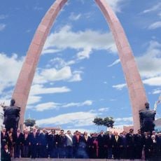
Between late August and early September streets fill with national flags and parades during a multiday celebration of the city's reincorporation into Peruvian territory. Residents prepare traditional dishes and invite relatives from neighboring regions to commemorate the historical return together.
Location: Tacna
Inception: June 25, 1875
Elevation above the sea: 552 m
GPS coordinates: -18.01386,-70.25110
Latest update: December 4, 2025 19:04
Morro de Arica
52.5 km
Parabolic Arch of Tacna
47 m
Estadio Carlos Dittborn
53 km
Caplina River
15.2 km
St. Mark's Cathedral
52.3 km
Miculla petroglyphs
22.8 km
Península del Alacrán
52.6 km
Tacna Ornamental Fountain
9 m
Casa Bolognesi
52.4 km
Estadio Jorge Basadre
1 km
Playa Chinchorro
50.3 km
Mosque Bab ul Islam
900 m
Arica House of Culture
52.1 km
Museo Histórico y de Armas del Morro de Arica
52.5 km
Municipal Theatre of Tacna
481 m
Casino de Juegos de Arica
51.7 km
House Yanulaque
52.3 km
Tacna Prefecture
71 m
Monumento al soldado desconocido, Arica
52.6 km
Playa Las Machas
48.4 km
Iglesia de San Jerónimo, Poconchile
52.6 km
Phare Concordia
39.1 km
Phare de la péninsule du Scorpion
52.6 km
Cristo de la Concordia, Arica
52.4 km
Settlement and Artificial Mummification of the Chinchorro Culture in the Arica and Parinacota Region
52.6 km
Fuerte Ciudadela
53.3 km
Humedal de la desembocadura del Río Lluta
45.1 km
Cuartel n.º 1 del Regimiento Reforzado n.º 4 “Rancagua” de Arica
51.4 kmReviews
Visited this place? Tap the stars to rate it and share your experience / photos with the community! Try now! You can cancel it anytime.
Discover hidden gems everywhere you go!
From secret cafés to breathtaking viewpoints, skip the crowded tourist spots and find places that match your style. Our app makes it easy with voice search, smart filtering, route optimization, and insider tips from travelers worldwide. Download now for the complete mobile experience.
A unique approach to discovering new places❞
— Le Figaro
All the places worth exploring❞
— France Info
A tailor-made excursion in just a few clicks❞
— 20 Minutes