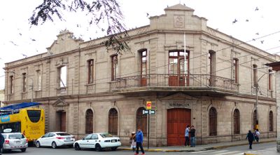
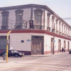
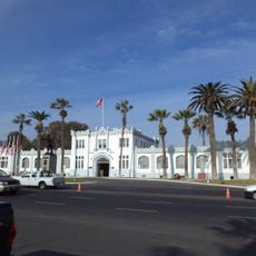
Tacna Prefecture, Historical administrative building on Blondell Street, Tacna, Peru
Tacna Prefecture is a stone administrative building on Blondell Street constructed in the early 1900s using materials from the Arunta and Intiorko hills. Though damaged by fire in 1908, the stone facade retains its original classical features and gives the building its recognizable character.
The building was erected in the early 1900s and served multiple purposes under Chilean control from 1905 to 1929, housing courts, prisons, and postal services. After Peru regained control, Chilean symbols were removed and institutional inscriptions were replaced.
The building reflects how regional administration looked and functioned in early 20th-century Peru through its design and layout. Its walls and inscriptions reveal shifts in power and identity that reshaped the place over time.
The building is in a damaged state, so exercise caution when approaching and some interior areas may not be accessible. It is best to view and appreciate the stonework and facade from the street outside.
The building was constructed using stone extracted from two nearby hills, making it a practical source of building material for its time. These locally sourced materials show how early administrative structures were connected to their surroundings.
The community of curious travelers
AroundUs brings together thousands of curated places, local tips, and hidden gems, enriched daily by 60,000 contributors worldwide.