Pucusana

Log in to your account

AroundUs is a community-driven map of interesting places, built by curious explorers like you. It grows with every review, story, and photo you share.
Connect to save your favorite spots, contribute locations, and create personalized routes.
Continue with Google
Continue with Apple
Continue with X
Continue with Facebook
Continue with email
By continuing, you accept our Terms and Conditions and our Privacy Policy
Create an account
Add to collection
Map
Suggest a change
Share

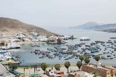
Pucusana, Coastal district in Lima Province, Peru.

Pucusana is a coastal district in Lima Province that stretches along the Pacific Ocean with several beaches including Las Culebritas, Las Ninfas, and La Yesera. Red hills frame the settlement, where a natural fishing cove serves as the focal point, with a fishing pier and sports dock providing the main infrastructure.

The settlement was formally established as a district on January 22, 1943, under President Manuel Prado Ugarteche's administration. This administrative recognition marked the transition from an informal fishing community to an officially recognized territorial entity.

The name Pucusana comes from ancient words meaning 'abundance of red,' referring to the reddish hills that frame the fishing cove. The settlement has long been shaped by its relationship to the ocean and the rhythms of fishing life that continue to define daily activity here.

The area is best explored on foot, with the main activity concentrated around the fishing cove and the docks. Visitors should be prepared for uneven ground and stairs, especially when exploring the beaches and viewpoints among the hills.

A geological formation called Corte de La Viuda shows a natural phenomenon where the ocean penetrates through cracks in the coastal mountains. This site offers an intriguing look at how erosion has shaped the landscape where mountain and sea meet.

Location: Lima province

Capital city: Pucusana

Elevation above the sea: 15 m

Shares border with: Chilca District, Santa María del Mar

Website: http://munipucusana.gob.pe

GPS coordinates: -12.41667,-76.78333

Latest update: December 22, 2025 17:38

Photos
Reviews

Visited this place? Tap the stars to rate it and share your experience / photos with the community! Try now! You can cancel it anytime.

« Pucusana - Coastal district in Lima Province, Peru » is provided by Around Us (aroundus.com). Images and texts are derived from Wikimedia project under a Creative Commons license. You are allowed to copy, distribute, and modify copies of this page, under the conditions set by the license, as long as this note is clearly visible.

Discover hidden gems everywhere you go!

From secret cafés to breathtaking viewpoints, skip the crowded tourist spots and find places that match your style. Our app makes it easy with voice search, smart filtering, route optimization, and insider tips from travelers worldwide. Download now for the complete mobile experience.

Around Us App Screenshot

A unique approach to discovering new places

Le Figaro

All the places worth exploring

France Info

A tailor-made excursion in just a few clicks

20 Minutes