·

Enable Location

We need your location to show you interesting places around you

Discover nearby places

Find interesting locations and hidden gems around you

Precise directions

Get accurate directions and distances to places

Your location is never shared with other users. It's only used when you tap the location button.

El Agustino District

Log in to your account

Start exploring — it's free

Trusted by 62,661 travelers worldwide

Continue with Google
Continue with Apple
or

We will send you a code to connect

By continuing, you accept our Terms and Conditions and our Privacy Policy

Check your inbox

We've sent a pincode in your inbox. Please enter the code below.

El Agustino District

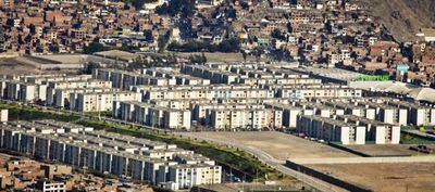
El Agustino District, Administrative district in Lima, Peru.

El Agustino is a district in Lima that spans multiple neighborhoods with diverse housing areas throughout. The area features a dense network of streets filled with local markets, small shops, and residential buildings of varying sizes.

The land was part of a hacienda until 1925 where fruit, vegetables, and flowers were cultivated. Afterward, settlement grew significantly, especially from the middle of the 20th century onward, as people from mountain regions built new communities here.

The district is home to many families from Peru's highlands who settled here and maintained their Andean traditions through daily life and celebrations. You can see this in local markets and the way people gather for festivals and community events.

The district is well-connected by bus to other parts of Lima and easy to navigate. Local markets are scattered throughout and offer fresh produce and everyday items within walking distance.

The neighborhood is known for its textile production with small tailoring and weaving workshops operated from private homes. This informal economy shapes the streetscape and livelihoods of many residents.

The community of curious travelers

AroundUs brings together thousands of curated places, local tips, and hidden gems, enriched daily by 60,000 contributors worldwide.

Start exploring
Location
Elevation above the sea
197 m
Shares border with
San Juan de Lurigancho, Lurigancho-Chosica, Ate District, Santa Anita, San Luis, Lima District
GPS coordinates
-12.05000,-77.00000
Latest update
December 22, 2025 13:46
« El Agustino District - Administrative district in Lima, Peru » is provided by Around Us (aroundus.com). Images and texts are derived from Wikimedia project under a Creative Commons license. You are allowed to copy, distribute, and modify copies of this page, under the conditions set by the license, as long as this note is clearly visible.

Discover hidden gems everywhere you go!

From secret cafés to breathtaking viewpoints, skip the crowded tourist spots and find places that match your style. Our app makes it easy with voice search, smart filtering, route optimization, and insider tips from travelers worldwide. Download now for the complete mobile experience.

Around Us App Screenshot

A unique approach to discovering new places

Le Figaro

All the places worth exploring

France Info

A tailor-made excursion in just a few clicks

20 Minutes

Around Us
Travel Guide & Maps
Download

Send to your phone

QR Code
1

Open the camera app on your mobile.

2

Point at the QR code with your camera. A notification will appear.

3

Tap the notification to open the link.