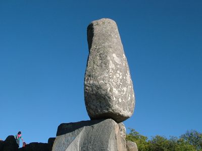
El Centinela, Summit in Tandil, Argentina
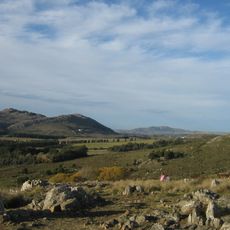
El Centinela is a summit in the Tandil mountain system, rising above the surrounding plains with rocky granite formations throughout. The peak can be reached by following established trails that ascend from the base and offer expanded views as you climb higher.
The summit served as a strategic vantage point during the 1800s for settlers who needed to monitor the vast plains below. This role made it a key location for early people moving through and developing the region.
The summit's name translates to watchman or sentinel in Spanish, reflecting how the local community has long understood this place as something that guards the land. People gather here to experience the views and feel connected to this significant location.
The hike to the summit takes roughly two hours on a well-marked trail starting from the parking area at the base. Wear sturdy shoes and bring water, as the route crosses rocky ground and gains elevation steadily.
The summit features natural granite formations that are shaped like seats, allowing visitors to watch both sunrise and sunset from a single spot. These carved-by-nature shapes make the location ideal for spending extended time and experiencing how the light changes throughout the day.
GPS coordinates: -37.35547,-59.17198
Latest update: December 10, 2025 15:48
Piedra Movediza
5.1 km
Castillo San Francisco
45.3 km
Parque Independencia
3.6 km
Museo de Ciencias Naturales Gesué Pedro Noseda
96.6 km
Reserva natural Sierra del Tigre
4.8 km
Santísimo Sacramento Church, Tandil
4.3 km
Our Lady of the Rosary Cathedral
89 km
La Huerta
9 km
Capilla Santa Gemma
3.4 km
Casa Ronco
89.1 km
Iglesia de Nuestra Señora del Rosario
30.4 km
Cementerio municipal de Azul
88.5 km
De La Canal train station
26.1 km
The Great Museum Lobería
96.5 km
Teatro Español
88.9 km
Museo Ferroviario - Ferro Club Azul
87.6 km
Matadero de Chillar
73.4 km
Cementerio de Azul
88.5 km
Cristo y Vía Crucis de Azul
86.3 km
Portal del Parque Municipal 'Domingo Faustino Sarmiento'
89 km
Matadero de Azul
84.1 km
Plazoleta de la Municipalidad de Rauch
65.1 km
Portal del Cementerio de Azul
88.5 km
Plaza San Martín
88.9 km
Museo Municipal De Bellas Artes De Tandil (Mumbat)
4.1 km
Delegación municipal de Chillar
72.1 km
Iglesia Parroquial Matriz Santísimo Sacramento
4.3 km
Plaza Libertad
97.6 kmVisited this place? Tap the stars to rate it and share your experience / photos with the community! Try now! You can cancel it anytime.
Discover hidden gems everywhere you go!
From secret cafés to breathtaking viewpoints, skip the crowded tourist spots and find places that match your style. Our app makes it easy with voice search, smart filtering, route optimization, and insider tips from travelers worldwide. Download now for the complete mobile experience.
A unique approach to discovering new places❞
— Le Figaro
All the places worth exploring❞
— France Info
A tailor-made excursion in just a few clicks❞
— 20 Minutes