Almirante Brown Partido
Almirante Brown Partido, Administrative division in Greater Buenos Aires, Argentina
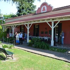
Almirante Brown Partido is an administrative area in Buenos Aires Province that encompasses several towns including Adrogué, Burzaco, and Claypole. The territory spreads across flat land organized into distinct neighborhoods that together form a larger urban region.
The partido was founded in 1873 when merchant Esteban Adrogué donated land for a railway station, sparking urban growth across the area. This early investment in rail connections enabled communities to develop and attract residents.
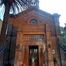
Strong Catholic traditions shape the area, visible in the churches and schools that stand throughout the neighborhoods as gathering places for residents. These institutions remain central to local community life and identity today.
The area has flat terrain and good road connections linking the different towns, making navigation straightforward for visitors. Most neighborhoods are reachable on foot or by local transport, allowing easy exploration of the region.
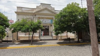
The area is shaped by strong Italian immigration heritage, which remains visible in family networks and local businesses passed down through generations. This legacy influences local food, traditions, and the character of daily life in ways many visitors overlook.
Location: Buenos Aires Province
Capital city: Adrogué
Elevation above the sea: 24 m
Part of: Buenos Aires Province
Website: https://almirantebrown.gov.ar
GPS coordinates: -34.78333,-58.40000
Latest update: December 10, 2025 20:08
Santa Catalina nature reserve
3.4 km
Santa Ana Church, Glew
12.1 km
Museo Histórico Municipal La Campana
6.3 km
William Henry Hudson Museum
17.5 km
Ferroclub Argentino CDP Remedios de Escalada
5.8 km
Centro De Veteranos De Guerra De Malvinas De Quilmes
12.1 km
Villa Grampa
967 m
Fundación Soldi
12 km
Biblioteca Popular Antonio Mentruyt
2.5 km
Iglesiа Оrtоdоxа Rusа de lа Virgen del Аmраrо, Temperley
18 m
St. Andrew's Presbyterian Church, Temperley
1.1 km
Museo Histórico Provincial “Guillermo Enrique Hudson”
17.1 km
Museo Histórico La Campana
9 km
Museum of Contemporary Art South
8.4 km
Casa Borges
2.1 km
Museo Manigrasso. Exposición de Cerámica Toscana
12.4 km
Museo comunitario de Artes Visuales e Histórico de Florencio varela
11.2 km
Museo del tren R. Escalada
5.8 km
Ex station Monte Chingolo
7.4 km
Museo Historico Juan Piñeiro
8.7 km
Centro de Veteranos de Guerra "Soberanía Nacional"
15.3 km
Museum Claudio León Sempere Art
4.9 km
Vieja Estacion Monteverde
11.5 km
Museo Pio Collivadino
3.9 km
Museo Americanista
2.9 km
Monumento ecuestre al Gral. San Martín
2.9 km
Conjunto formado por la Iglesia Catedral y Basílica de Nuestra Señora de la Paz, la sede Parroquial (ex Instituto "Presbítero Dr. Antonio Sáenz") y la casa Parroquial
2.8 km
Quinta Los Leones
3.9 kmVisited this place? Tap the stars to rate it and share your experience / photos with the community! Try now! You can cancel it anytime.
Discover hidden gems everywhere you go!
From secret cafés to breathtaking viewpoints, skip the crowded tourist spots and find places that match your style. Our app makes it easy with voice search, smart filtering, route optimization, and insider tips from travelers worldwide. Download now for the complete mobile experience.
A unique approach to discovering new places❞
— Le Figaro
All the places worth exploring❞
— France Info
A tailor-made excursion in just a few clicks❞
— 20 Minutes