Río Negro Department

Log in to your account

AroundUs is a community-driven map of interesting places, built by curious explorers like you. It grows with every review, story, and photo you share.
Connect to save your favorite spots, contribute locations, and create personalized routes.
By continuing, you accept our Terms and Conditions and our Privacy Policy
Add to collection
Map
Suggest a change
Share

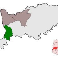
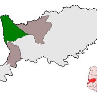
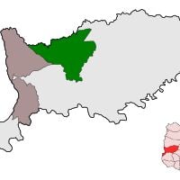
Río Negro Department, Administrative division in northwestern Uruguay

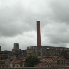
Río Negro Department is an administrative region in northwestern Uruguay along the Uruguay River. The area is characterized by agricultural lands, several river courses, and the city of Fray Bentos as its main center.

The region was separated from Paysandú in 1880 and established as an independent administrative unit during a major territorial reorganization of Uruguay. This restructuring led to new borders and its own local governance structure.

The population maintains agricultural traditions and local crafts, particularly ceramics, which visitors can see practiced in small workshops throughout the region. These everyday practices shape how the community gathers and celebrates together.

The best time to visit is during the dry season when roads are easier to navigate and rivers are lower. Visitors should note that the region is largely rural and requires time to explore smaller routes at a leisurely pace.

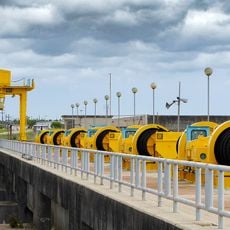
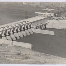
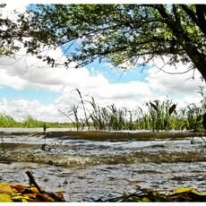
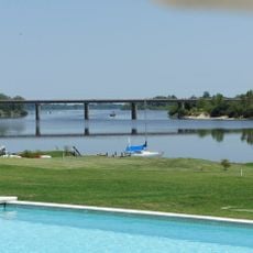
Two major hydroelectric dams, Rincón de Baygorria and Constitución, alter the river landscape and shape the region's appearance. These structures create large artificial lakes that fundamentally change the natural flow of the Uruguay River.

Inception: 1868

Capital city: Fray Bentos

Elevation above the sea: 70 m

Part of: South America Midwest Integrated Zone

Shares border with: Paysandú Department, Tacuarembó Department, Soriano Department, Durazno Department, Flores Department, Entre Ríos Province

Website: http://rionegro.gub.uy

GPS coordinates: -33.12472,-58.30028

Latest update: December 7, 2025 10:03

Around this place
Show the full map
Frigorífico Anglo del Uruguay
Uruguay

Frigorífico Anglo del Uruguay

959 m
Palmar Dam
Uruguay

Palmar Dam

79.7 km
Represa de Baygorria
Uruguay

Represa de Baygorria

142.3 km
Colegio del Uruguay
Argentina

Colegio del Uruguay

71.6 km
Palace Cave
Uruguay

Palace Cave

110 km
Reserva de flora y fauna Dr. Rodolfo Tálice
Uruguay

Reserva de flora y fauna Dr. Rodolfo Tálice

133.8 km
Parque Nacional de los Esteros de Farrapos e Islas del Río Uruguay
Uruguay

Parque Nacional de los Esteros de Farrapos e Islas del Río Uruguay

46.5 km
Área protegida Montes del Queguay
Uruguay

Área protegida Montes del Queguay

132.8 km
Monumento a Perpetuidad, Paysandú
Uruguay

Monumento a Perpetuidad, Paysandú

91.4 km
Nuestra Señora del Rosario y San Benito de Palermo, Paysandú
Uruguay

Nuestra Señora del Rosario y San Benito de Palermo, Paysandú

92.2 km
Teatro Florencio Sánchez
Uruguay

Teatro Florencio Sánchez

92.1 km
Reserva forestal Chaviyú
Argentina

Reserva forestal Chaviyú

73.3 km
National Technological University – Concepción del Uruguay Regional Faculty
Argentina

National Technological University – Concepción del Uruguay Regional Faculty

70.3 km
Museo Luis Alberto Solari
Uruguay

Museo Luis Alberto Solari

1.6 km
Stella Maris Lighthouse
Argentina

Stella Maris Lighthouse

73 km
Centro de Documentación e Investigación Daniel Vidart
Uruguay

Centro de Documentación e Investigación Daniel Vidart

92 km
San Isidro Golf & Yacht Club
Uruguay

San Isidro Golf & Yacht Club

30.1 km
Centro de detención del Batallón de Infantería No. 9
Uruguay

Centro de detención del Batallón de Infantería No. 9

1.3 km
Catedral de Trinidad, Flores
Uruguay

Catedral de Trinidad, Flores

137.6 km
Biblioteca Popular El porvenir
Argentina

Biblioteca Popular El porvenir

71.4 km
Basilica of Our Lady of the Rosary and Saint Benedict of Palermo
Uruguay

Basilica of Our Lady of the Rosary and Saint Benedict of Palermo

92.2 km
Monumento al Himno Nacional
Uruguay

Monumento al Himno Nacional

91.5 km
Casa que habito el Gral. Benjamín Victorica
Argentina

Casa que habito el Gral. Benjamín Victorica

71.7 km
Edificio del antiguo Hospital y Asilo Pinillas. Primer hospital de caridad de las Hermanas del Huerto construido en 1883 - Actual Sede de la Casa del Espíritu de Paysandú.
Uruguay

Edificio del antiguo Hospital y Asilo Pinillas. Primer hospital de caridad de las Hermanas del Huerto construido en 1883 - Actual Sede de la Casa del Espíritu de Paysandú.

92.1 km
Jefatura de policía de Paysandu
Uruguay

Jefatura de policía de Paysandu

92 km
Edificio de la Aduana Vieja
Argentina

Edificio de la Aduana Vieja

70.3 km
Casa del Gral. Justo José de Urquiza
Argentina

Casa del Gral. Justo José de Urquiza

71.6 km
La Vanguardia Polo & Golf
Uruguay

La Vanguardia Polo & Golf

80.4 km
Show the full map

Reviews

Visited this place? Tap the stars to rate it and share your experience / photos with the community! Try now! You can cancel it anytime.

« Río Negro Department - Administrative division in northwestern Uruguay » is provided by Around Us (aroundus.com). Images and texts are derived from Wikimedia project under a Creative Commons license. You are allowed to copy, distribute, and modify copies of this page, under the conditions set by the license, as long as this note is clearly visible.

Discover hidden gems everywhere you go!

From secret cafés to breathtaking viewpoints, skip the crowded tourist spots and find places that match your style. Our app makes it easy with voice search, smart filtering, route optimization, and insider tips from travelers worldwide. Download now for the complete mobile experience.

Around Us App Screenshot

A unique approach to discovering new places

Le Figaro

All the places worth exploring

France Info

A tailor-made excursion in just a few clicks

20 Minutes