Igrejinha, Municipality in Rio Grande do Sul, Brazil.
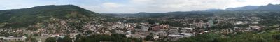
Igrejinha is a municipality in southern Rio Grande do Sul situated in a hilly region at approximately 371 meters elevation. The area spans about 136 square kilometers and is home to around 30,700 residents in a territory with established infrastructure.
The municipality was officially founded on June 26, 1964, receiving its administrative independence. This founding moment marked the beginning of independent management in the region.
The annual Oktoberfest draws visitors with German and Brazilian music, dancing, and regional food traditions. This celebration reflects the deep German heritage present in the community, shaping local customs and daily life to this day.
The area is easily accessible from Porto Alegre and has established transportation connections to neighboring cities. Visitors find urban infrastructure that makes it straightforward to move around the municipality and explore surrounding areas.
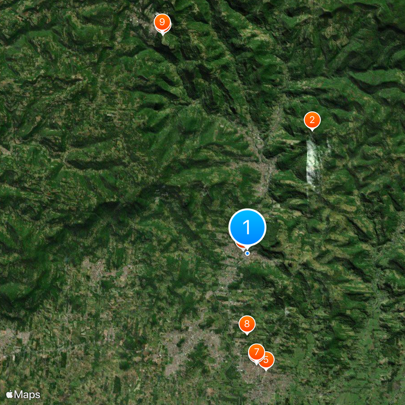
Parque Alto da Pedra offers natural spaces and walking trails in a green setting. The nearby Morro Alto da Pedra serves as a natural viewpoint and local landmark for the area.
Location: Rio Grande do Sul
Inception: June 26, 1964
Elevation above the sea: 371 m
Shares border with: Taquara, Parobé, Nova Hartz, Santa Maria do Herval, Três Coroas
Website: http://igrejinha.rs.gov.br
GPS coordinates: -29.57389,-50.79000
Latest update: December 20, 2025 13:42
Khadro Ling Buddhist Temple
10.3 km
GramadoZoo
17.4 km
Igreja Gabriel
407 mMuseu Arqueológico do Rio Grande do Sul
8.7 kmAssociação Comercial e Industrial de Taquara
8.2 kmMuseo Histórico Municipal Adelmo Trott
8 kmQuilombo Paredão
5.9 kmParque Gaúcho Centro Cultural Ltda
17.5 kmMuseu Histórico de Nova Hartz
11 kmMuseu Professor Gustavo Adolfo Koetz
2.4 kmMuseu Municipal Armindo Lauffer
6.6 kmCascata Arroio da Bica
13.5 kmScenic viewpoint
8.1 kmCascata Nova Hartz
12.9 kmRaft Adventure
16.5 kmPórtico de Igrejinha
328 mPórtico de Araricá
15.2 kmFACCAT - Palco Aberto
7.3 kmScenic viewpoint
5.9 kmScenic viewpoint
6.9 kmCascata Caloni
6.9 kmScenic viewpoint
11.4 kmScenic viewpoint
7.1 kmWaterfall
14.9 kmWaterfall
10.4 kmWaterfall
12.6 kmCascata da Solitária
5.4 kmWaterfall
17.5 kmVisited this place? Tap the stars to rate it and share your experience / photos with the community! Try now! You can cancel it anytime.
Discover hidden gems everywhere you go!
From secret cafés to breathtaking viewpoints, skip the crowded tourist spots and find places that match your style. Our app makes it easy with voice search, smart filtering, route optimization, and insider tips from travelers worldwide. Download now for the complete mobile experience.
A unique approach to discovering new places❞
— Le Figaro
All the places worth exploring❞
— France Info
A tailor-made excursion in just a few clicks❞
— 20 Minutes