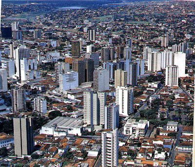
Uberlândia, Commercial and educational center in western Minas Gerais, Brazil.
Uberlândia stretches across the Brazilian Highlands at 2830 feet (863 meters) between the Paranaíba and Grande rivers and counts more than 699,000 residents. It sits in western Minas Gerais and connects commercial activity with educational institutions.
The town received official city status in 1892 after being founded as a strategic post between São Paulo state and the developing central regions. Its location encouraged growth as a trade and distribution center over the decades.
The town museum presents the regional past in a former city hall and offers educational programs about Minas Gerais traditions. The building sits downtown and organizes regular exhibits on local themes.
Five federal highways pass through and link it with São Paulo and Brasília, while an airport adds to the transport network. The place serves as a hub for freight and regional connections.
Sabiá Park holds several lakes and an aquarium together with a zoo and running tracks that are open to visitors. The park ranks among the most visited recreation areas in town and is often used for walks.
Location: Minas Gerais
Inception: August 31, 1888
Elevation above the sea: 837 m
Shares border with: Monte Alegre de Minas, Uberaba, Indianópolis, Araguari, Prata, Tupaciguara, Veríssimo
Website: http://www3.uberlandia.mg.gov.br
GPS coordinates: -18.91889,-48.27694
Latest update: December 14, 2025 22:08
Estádio Parque do Sabiá
4.7 km
Estádio Juca Ribeiro
888 mMuseo Municipal de Uberlândia
694 mMuseu de Biodiversidade do Cerrado
504 mMuseu de Minerais e Rochas
504 mMuseu dos Ferroviários de Araguari
31.6 kmBosque Municipal John Kennedy
31.4 kmPrainha das Capivaras
4 kmCachoeira do Marimbondo
15.5 kmCurral de Pedras
16.1 kmBosque das Aroeiras
16.8 kmRoda Dágua
15.7 kmAntiga E. E. Machado de Assis
30.7 kmCachoeira do Fundão
24.1 kmVistoria caixa
34.2 kmPalácio dos Ferroviários (Prefeitura de Araguari)
31.7 kmLocomotiva 01 da Estrada de Ferro Goyaz
31.5 kmFigueira Centenária
23 kmLocomotiva 01 da Estrada de Ferro Goyaz
31.5 kmToboágua amarelo
33.7 kmSão Judas Tadeu
32.2 kmBusto de Tubal Vilela
212 mBusto de Grande Otelo
265 mCabeção do J.K.
204 mBusto do Homem sem Nome
630 mBusto de Felisberto Carrijo
1 kmBusto de Coronel Carneiro
998 mCombatente da Engenharia Militar
32.9 kmVisited this place? Tap the stars to rate it and share your experience / photos with the community! Try now! You can cancel it anytime.
Discover hidden gems everywhere you go!
From secret cafés to breathtaking viewpoints, skip the crowded tourist spots and find places that match your style. Our app makes it easy with voice search, smart filtering, route optimization, and insider tips from travelers worldwide. Download now for the complete mobile experience.
A unique approach to discovering new places❞
— Le Figaro
All the places worth exploring❞
— France Info
A tailor-made excursion in just a few clicks❞
— 20 Minutes