Capitólio, Municipality in Minas Gerais, Brazil
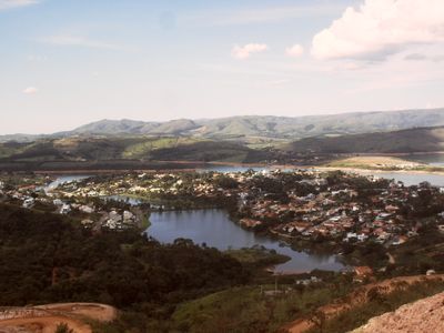
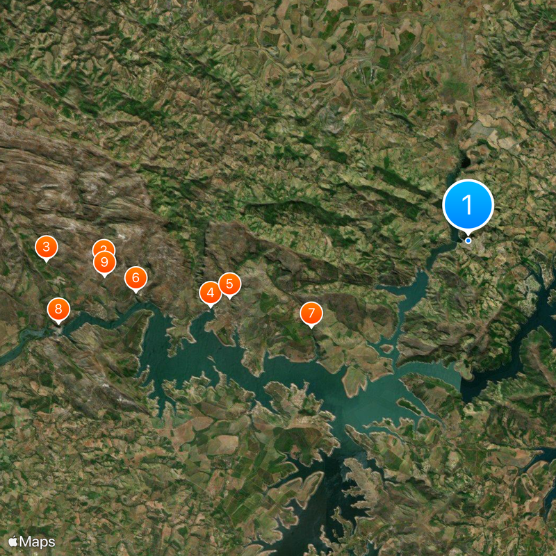
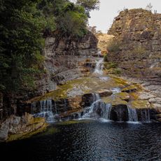
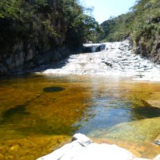
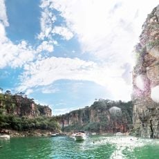
Capitólio is an administrative division in Minas Gerais, Brazil, stretching along the Furnas reservoir and offering access to waterways and geological formations. The landscape includes canyons with steep rock walls, coves with clear water, and forested hills that extend to the shoreline.
The settlement was officially founded in 1948 and originally served as a supply point for the surrounding rural region. With the construction of the Furnas dam in the 1960s, parts of the original town sank underwater and the municipality developed anew along the created lake.
The name refers to the government building in Brasília and reflects the administrative role that has existed since its founding. Fishermen bring their daily catch to the shores, where restaurants serve fresh fish from the reservoir and visitors can try regional dishes.
Access is through highways branching from larger cities in the Minas Gerais region, leading to the main town center. Best visiting time is between May and September, when weather is dry and views of the rock formations remain clear.
When water levels drop, ruins of the old town emerge at the northern edge of the reservoir, showing foundations of former buildings. These structures attract curious visitors who approach by boat and want to discover the forgotten past beneath the surface.
Location: Minas Gerais
Elevation above the sea: 766 m
Shares border with: Guapé, São José da Barra, São João Batista do Glória, Pimenta, Piumhi, Vargem Bonita
Website: http://capitolio.mg.gov.br
GPS coordinates: -20.61500,-46.05000
Latest update: December 4, 2025 23:04
Serra da Canastra National Park
62.1 km
Casca d'Anta
60.3 km
Melão
125.2 km
Mascarenhas de Morais Dam
111.9 km
Relógio Solar de Franca
141.1 km
Nave Espacial de Varginha
122.7 km
Pedra Balão
138 km
José Chiachiri Municipal Historical Museum
140.9 km
Basilica Shrine of Our Lady of the Immaculate Conception, Caconde
119.2 km
Cathedral of Our Lady of Sorrows
103.2 km
Praça das Esculturas
144.7 km
Parque Ecológico São Sebastião
138.1 km
Casa de Zinco
139.7 km
Pinacoteca Municipal Miguel Ângelo Pucci
140.9 km
Cachoeira da Capivara
24.8 km
Paraíso Perdido
28.7 km
Casa de Cultura Rogério Cardoso
137.1 km
E.E. Coronel Francisco Martins
140.9 km
Ponte Metálica Euclides da Cunha
140 km
E.M.E.F. Coronel Joaquim da Cunha
145 km
Saint Barbara Church (Guaranésia)
109.2 km
Complexo Hidrotermal e Hoteleiro do Barreiro
143.1 km
Horizonte Perdido
130.9 km
Bridge over the river Turvo
18 km
Antiga Casa de Câmara e Cadeia de São José do Rio Pardo
139.7 km
Canyon de Furnas
22.8 km
Termas de Araxá
143 km
Monumento em Homenagem aos Profissionais da Saúde (Piumhi/MG)
18.9 kmReviews
Visited this place? Tap the stars to rate it and share your experience / photos with the community! Try now! You can cancel it anytime.
Discover hidden gems everywhere you go!
From secret cafés to breathtaking viewpoints, skip the crowded tourist spots and find places that match your style. Our app makes it easy with voice search, smart filtering, route optimization, and insider tips from travelers worldwide. Download now for the complete mobile experience.
A unique approach to discovering new places❞
— Le Figaro
All the places worth exploring❞
— France Info
A tailor-made excursion in just a few clicks❞
— 20 Minutes