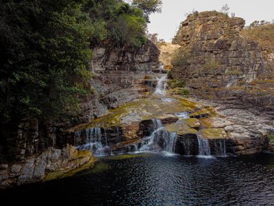
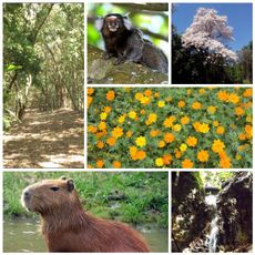
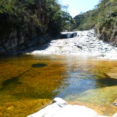
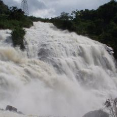
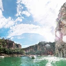
Cachoeira da Capivara, Natural waterfall in Capitólio, Brazil.
Cachoeira da Capivara is a waterfall in Capitólio featuring multiple natural pools of varying sizes and depths along a flowing stream. A trail runs alongside the waterway and allows access to different swimming areas throughout the location.
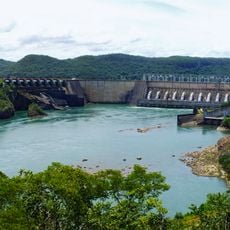
The waterfall is part of the Capivara Stream system that flows into Furnas Lake, representing the natural water networks that have shaped the Minas Gerais region. The area has long been a natural feature of the local water system.
This waterfall serves as a popular gathering spot where visitors swim and explore the natural pools formed by the stream. The surrounding rocks provide natural seating areas where people spend time enjoying the water and landscape.
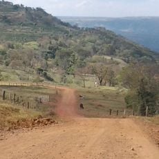
The drive to reach this waterfall involves traveling on an unpaved road, so sturdy footwear and extra time are recommended. Visiting early in the day or outside peak hours helps you experience the location with fewer crowds.
The area contains a series of natural pools distributed along the stream course, offering different exploration opportunities for each visitor. These scattered water spots allow people to discover different sections of the waterway and find their preferred swimming areas.
Location: Capitólio
GPS coordinates: -20.62916,-46.28778
Latest update: December 6, 2025 19:02
The central west region of Brazil encompasses states including Goiás, Mato Grosso and Mato Grosso do Sul. These areas contain national parks with hiking trails, waterfalls and cave systems. Chapada dos Veadeiros National Park near Alto Paraíso de Goiás displays cerrado vegetation and rock formations. Bonito offers clear rivers for snorkeling, while Pirenópolis combines colonial architecture with nearby nature reserves. Terra Ronca State Park contains underground rivers and limestone caves. The Pantanal area spans Mato Grosso and hosts various wildlife species. Chapada dos Guimarães near Cuiabá shows sandstone formations and viewpoints over the surrounding plains. The Jalapão region in Tocantins features dune landscapes and natural springs. These locations draw hikers, cave explorers and travelers looking to experience remote natural areas.
Serra da Canastra National Park
47.7 km
Casca d'Anta
43.9 km
Mascarenhas de Morais Dam
89.5 km
Relógio Solar de Franca
116.5 km
Pedra Balão
129 km
José Chiachiri Municipal Historical Museum
116.3 km
Basilica Shrine of Our Lady of the Immaculate Conception, Caconde
106.9 km
Cathedral of Our Lady of Sorrows
87.3 km
Praça das Esculturas
120.8 km
Parque Ecológico São Sebastião
120.3 km
Casa de Zinco
124.4 km
Furnas do Bom Jesus State Park
128.2 km
Pinacoteca Municipal Miguel Ângelo Pucci
116.3 km
Paraíso Perdido
3.9 km
Casa de Cultura Rogério Cardoso
119.2 km
Ponte Metálica Euclides da Cunha
124.6 km
Christ the Redemeer
130.7 km
Cascata das Antas
130.7 km
Saint Barbara Church (Guaranésia)
91.9 km
Bridge over the river Turvo
7.8 km
Horizonte Perdido
118 km
Complexo Hidrotermal e Hoteleiro do Barreiro
129.5 km
Antiga Casa de Câmara e Cadeia de São José do Rio Pardo
124.4 km
Recanto Japonês
130.6 km
Canyon de Furnas
2.9 km
Parque Municipal da Serra de São Domingos
130.6 km
Termas de Araxá
129.4 km
Monumento em Homenagem aos Profissionais da Saúde (Piumhi/MG)
38.8 kmReviews
Visited this place? Tap the stars to rate it and share your experience / photos with the community! Try now! You can cancel it anytime.
Discover hidden gems everywhere you go!
From secret cafés to breathtaking viewpoints, skip the crowded tourist spots and find places that match your style. Our app makes it easy with voice search, smart filtering, route optimization, and insider tips from travelers worldwide. Download now for the complete mobile experience.
A unique approach to discovering new places❞
— Le Figaro
All the places worth exploring❞
— France Info
A tailor-made excursion in just a few clicks❞
— 20 Minutes