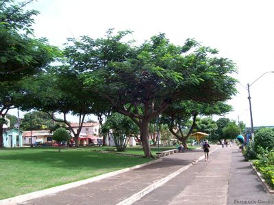
Açailândia, Industrial municipality in Maranhão, Brazil.
The municipality features a tropical climate at 240 meters elevation, with distinct wet and dry seasons throughout the calendar year.
The settlement grew after 1958 when the construction of the Belém-Brasília highway led to the discovery of fertile lands near Açailândia Creek.
Local festivities include traditional music performances, regional dance presentations, and food events that display the influences of indigenous communities.
The railway station on the Carajás line connects the municipality to main transportation routes, enabling efficient movement of goods and passengers.
The region maintains the largest cattle population in Maranhão state while operating as a central hub for pig iron production.
Location: Maranhão
Elevation above the sea: 240 m
Shares border with: Cidelândia, Bom Jesus das Selvas, Amarante do Maranhão, Bom Jardim, Dom Eliseu, Itinga do Maranhão, João Lisboa, Rondon do Pará, São Francisco do Brejão
Website: http://acailandia.ma.gov.br
GPS coordinates: -4.94694,-47.50500
Latest update: May 26, 2025 21:41
Chapada das Mesas National Park
232.6 km
Marabá Combined Bridge
179.3 km
Poço Azul
279 km
Espaço São José Liberto
403.1 km
Pedra Caida
233.6 km
Carajás National Forest
320.5 km
Murutucu Plantation
402.9 km
Estádio Municipal Zinho de Oliveira
186.6 km
Monumento das Castanheiras Mortas
237.6 km
Terra Indígena Mãe Maria
158.6 km
Gurupi Biological Reserve
156.4 km
Ponte Juscelino Kubitschek de Oliveira
179.6 km
Belém Lighthouse
403.2 km
Baixada Maranhense Environmental Protection Area
379.8 km
Puente Ferroviario de Estreito MA
179.4 km
São Geraldo do Araguaia Environmental Protection Area
187.4 km
Parakanã Indigenous Territory
297.3 km
Tapirapé Biological Reserve
351.7 km
Encanto Azul
281.9 km
Gems museum of Pará
403.1 km
Our Lady of the Conception Cathedral, Abaetetuba
390.4 km
Serra dos Martírios/Andorinhas State Park
174.7 km
St. Therese Cathedral, Bacabal
313.3 km
Biblioteca Pública Municipal Orlando Lima Lobo
186.6 km
Cajàzeira River
229.5 km
Quilombo Moju-miri
389.2 km
Terra Indígena Barreirinha
210.3 km
Catedral Nossa Senhora da Fátima, Imperatriz
65.2 kmReviews
Visited this place? Tap the stars to rate it and share your experience / photos with the community! Try now! You can cancel it anytime.
Discover hidden gems everywhere you go!
From secret cafés to breathtaking viewpoints, skip the crowded tourist spots and find places that match your style. Our app makes it easy with voice search, smart filtering, route optimization, and insider tips from travelers worldwide. Download now for the complete mobile experience.
A unique approach to discovering new places❞
— Le Figaro
All the places worth exploring❞
— France Info
A tailor-made excursion in just a few clicks❞
— 20 Minutes