Chest opened
+${chestReward.xp} XP
Explorer
NOUVEAU ×${chestReward.collectible.quantity}
tapez pour fermer
Chest locked

Open chests in the app

Around Us is built for your phone — chests unlock when you walk, explore and capture nearby places.

Enable Location

We need your location to show you interesting places around you

Discover nearby places

Find interesting locations and hidden gems around you

Precise directions

Get accurate directions and distances to places

Your location is never shared with other users. It's only used when you tap the location button.

Log in to your account

Start exploring — it's free

Trusted by 72,879 travelers worldwide

Continue with Google
Continue with Apple
or

We will send you a code to connect

By continuing, you accept our Terms and Conditions and our Privacy Policy

Check your inbox

We've sent a pincode in your inbox. Please enter the code below.

Batéké Plateau
Discussion Reviews Photo
5k Popularity

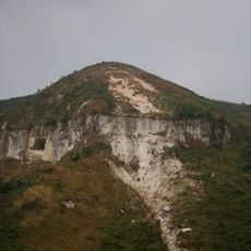
Batéké Plateau, Ancient plateau formation in Central Congo

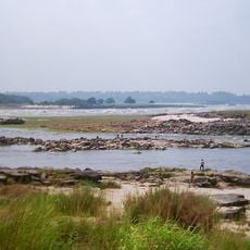
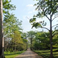
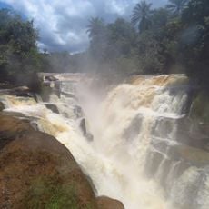
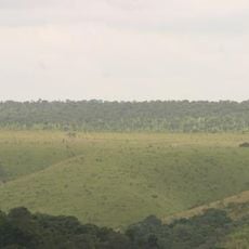
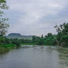
The Batéké Plateau is a highland region in central Congo that sits between 1,800 and 2,700 feet (550 and 830 meters) in elevation and combines savannas and forests in one landscape. Rolling hills, open grasslands, and patches of trees create the visual character of this vast land.

People have lived on this plateau for thousands of years, as shown by ancient tools and pottery fragments scattered across the region. The Batéké communities became established here and left behind traces of their early presence.

The Batéké people shape daily life on the plateau through farming and crafts that have been passed down for generations. Walking through settlements, you notice small cultivated plots and handmade goods that reflect how residents use their land.

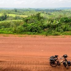
Roads are rough and spread across vast distances, so expect travel to take time and come prepared with sturdy transport. The tropical climate brings heavy rain at times, so bring waterproof gear and be ready for weather changes.

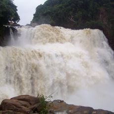
This plateau is where several major rivers begin their journey, including the Niari and Ogooué, which flow through Congo and into neighboring regions. These waterways have shaped the land and the communities that depend on them.

The community of curious travelers

AroundUs brings together thousands of curated places, local tips, and hidden gems, enriched daily by 60,000 contributors worldwide.

Start exploring
GPS coordinates
-3.51000,15.76000
Latest update
December 10, 2025 20:00
Around this place
Livingstone Falls
Congo

Livingstone Falls

109.2 km
Palace of the Nation
Congo, Democratic Republic of the

Palace of the Nation

103.1 km
Tour de l'Échangeur de Limete
Congo, Democratic Republic of the

Tour de l'Échangeur de Limete

106.7 km
Nsele Valley Park
Congo, Democratic Republic of the

Nsele Valley Park

84.5 km
National Museum of the Democratic Republic of Congo
Congo, Democratic Republic of the

National Museum of the Democratic Republic of Congo

105.1 km
Palais du Peuple
Congo, Democratic Republic of the

Palais du Peuple

104.7 km
Stade Municipal de Kintélé
Congo

Stade Municipal de Kintélé

86.6 km
Nabemba Tower
Congo

Nabemba Tower

99.7 km
Central Market, Kinshasa

Central Market, Kinshasa

102 km
Kisantu Botanical garden
Congo, Democratic Republic of the

Kisantu Botanical garden

196.4 km
Basilique Sainte-Anne-du-Congo de Brazzaville
Congo

Basilique Sainte-Anne-du-Congo de Brazzaville

99.6 km
Zongo Falls
Congo, Democratic Republic of the

Zongo Falls

170 km
Mont Mangengenge
Congo, Democratic Republic of the

Mont Mangengenge

106.5 km
Batéké Plateau National Park
Gabon

Batéké Plateau National Park

243.1 km
Case de Gaulle
Congo

Case de Gaulle

102.8 km
Kinshasa botanical garden
Congo, Democratic Republic of the

Kinshasa botanical garden

102.1 km
Loufoulakari waterfalls
Congo

Loufoulakari waterfalls

145.9 km
Stade 24 Novembre
Congo, Democratic Republic of the

Stade 24 Novembre

103.2 km
Sacred Heart Cathedral, Brazzaville
Congo

Sacred Heart Cathedral, Brazzaville

100.4 km
Our Lady of Seven Sorrows Cathedral, Kisantu
Congo, Democratic Republic of the

Our Lady of Seven Sorrows Cathedral, Kisantu

194.9 km
Domaine et réserve de Bombo-Lumene
Congo, Democratic Republic of the

Domaine et réserve de Bombo-Lumene

139.4 km
Kinsuka Bridge
Congo, Democratic Republic of the

Kinsuka Bridge

111.7 km
Stade Omnisports de Kinkala
Congo

Stade Omnisports de Kinkala

144.8 km
Léfini Faunal Reserve
Congo

Léfini Faunal Reserve

79.9 km
Statue de Pierre Savorgnan de Brazza
Congo

Statue de Pierre Savorgnan de Brazza

100.8 km
Église Saint-Pierre-Claver
Congo

Église Saint-Pierre-Claver

104.2 km
Stade de Djambala
Congo

Stade de Djambala

154.7 km
Bonobo Wildlife Station
Congo, Democratic Republic of the

Bonobo Wildlife Station

121.9 km
Show the full map
Reviews
Share your experience

No review yet

Discussions
Start a discussion...

No discussion yet

« Batéké Plateau - Ancient plateau formation in Central Congo » is provided by Around Us (aroundus.com). Images and texts are derived from Wikimedia project under a Creative Commons license. You are allowed to copy, distribute, and modify copies of this page, under the conditions set by the license, as long as this note is clearly visible.

Discover hidden gems everywhere you go!

From secret cafés to breathtaking viewpoints, skip the crowded tourist spots and find places that match your style. Our app makes it easy with voice search, smart filtering, route optimization, and insider tips from travelers worldwide. Download now for the complete mobile experience.

Around Us App Screenshot

A unique approach to discovering new places

Le Figaro

All the places worth exploring

France Info

A tailor-made excursion in just a few clicks

20 Minutes

Around Us
Travel Guide & Maps
Download

Send to your phone

QR Code
1

Open the camera app on your mobile.

2

Point at the QR code with your camera. A notification will appear.

3

Tap the notification to open the link.