Chest opened
+${chestReward.xp} XP
Explorer
NOUVEAU ×${chestReward.collectible.quantity}
tapez pour fermer
Chest locked

Open chests in the app

Around Us is built for your phone — chests unlock when you walk, explore and capture nearby places.

Enable Location

We need your location to show you interesting places around you

Discover nearby places

Find interesting locations and hidden gems around you

Precise directions

Get accurate directions and distances to places

Your location is never shared with other users. It's only used when you tap the location button.

Log in to your account

Start exploring — it's free

Trusted by 72,891 travelers worldwide

Continue with Google
Continue with Apple
or

We will send you a code to connect

By continuing, you accept our Terms and Conditions and our Privacy Policy

Check your inbox

We've sent a pincode in your inbox. Please enter the code below.

Kep Track
Discussion Reviews Photo
1.7k Popularity

Kep Track, track between Mundaring and Northam in Western Australia

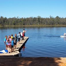
The Kep Track is a walk trail in Western Australia running approximately 75 kilometers from Mundaring Weir to Northam, mostly following old railway reserves. The path consists of firm, well-signed gravel surface with gentle slopes, passing through native forest, farmland, small towns, and sections where original rail lines remain visible.

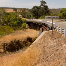
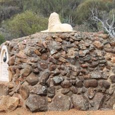
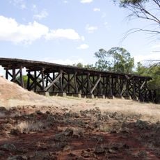
The trail follows the historic Eastern Railway route built in 1885 and operated until its closure in 1966. Old station buildings, monuments, and structures like the Clackline Bridge built in 1934 remain as reminders of the railway's role in connecting communities and supporting regional growth.

The name Kep comes from the local word for water, 'Gep', reflecting the route's deep connection to water management history. Small towns along the trail today preserve this legacy with old station buildings and monuments that tell visitors how the railway shaped community life here.

The trail is well-signed with a firm surface suitable for beginners, though it may become loose or muddy after rain. Visitors should carry plenty of water and sun protection, wear good footwear or use a sturdy bike, and travel during spring and summer months when weather is milder.

The Clackline Bridge built in 1934 is a remarkable curved timber structure crossing Mooka Creek and ranks among the longest curved wooden bridges in Australia. This engineering feat provides an unforgettable riding moment and displays the craftsmanship that went into the original railway construction.

The community of curious travelers

AroundUs brings together thousands of curated places, local tips, and hidden gems, enriched daily by 60,000 contributors worldwide.

Start exploring
GPS coordinates
-31.77002,116.37610
Latest update
February 9, 2026 20:57
Reviews
Share your experience

No review yet

Discussions
Start a discussion...

No discussion yet

« Kep Track - track between Mundaring and Northam in Western Australia » is provided by Around Us (aroundus.com). Images and texts are derived from Wikimedia project under a Creative Commons license. You are allowed to copy, distribute, and modify copies of this page, under the conditions set by the license, as long as this note is clearly visible.

Discover hidden gems everywhere you go!

From secret cafés to breathtaking viewpoints, skip the crowded tourist spots and find places that match your style. Our app makes it easy with voice search, smart filtering, route optimization, and insider tips from travelers worldwide. Download now for the complete mobile experience.

Around Us App Screenshot

A unique approach to discovering new places

Le Figaro

All the places worth exploring

France Info

A tailor-made excursion in just a few clicks

20 Minutes

Around Us
Travel Guide & Maps
Download

Send to your phone

QR Code
1

Open the camera app on your mobile.

2

Point at the QR code with your camera. A notification will appear.

3

Tap the notification to open the link.