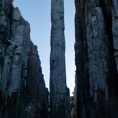
Tasman National Park, Nature reserve on Tasman Peninsula, Australia
Tasman National Park is a 107.5-square-kilometre reserve on the Forestier and Tasman peninsulas and Tasman Island, about 56 kilometres east of Hobart. Its columnar dolerite cliffs at Cape Pillar and Tasman Island reach 300 metres, among the highest in the world. Road-accessible formations include the Blowhole, Devils Kitchen and Waterfall Bay; Cathedral Rock, Totem Pole, Candlestick and Tasmans Arch are best seen from the ocean.
Whaling took place off these shores in the 1830s and 1840s, and late in the 1800s Royal Navy warships damaged the dolerite columns at Cape Raoul with gunnery practice. The Tasman Island Lighthouse was built in 1906 and has been unmanned since 1977. The park itself was proclaimed on 30 April 1999 under the Regional Forest Agreement.
The coastline was home for thousands of years to the Pydairerme, a clan of the Oyster Bay Nation, whose presence is marked by archaeological sites scattered across the rocky shores.
A 90-minute drive from Hobart provides access to the peninsula, with various walking trails of different lengths and difficulty levels. Plan to spend several hours to enjoy the best views of rock formations.
The Three Capes Track opened on 21 December 2015 and cost 25 million AUD, including 18,000 helicopter flights to build the route. It runs 46 km over three nights, with huts sleeping 48 people each and a Parks and Wildlife ranger stationed at every hut.
The community of curious travelers
AroundUs brings together thousands of curated places, local tips, and hidden gems, enriched daily by 93,952 contributors worldwide.