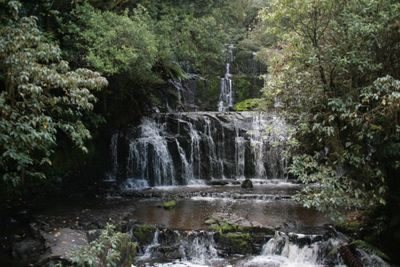
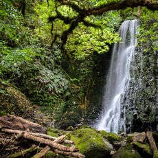
Purakaunui Falls, Three-tiered waterfall in The Catlins, New Zealand
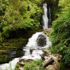
The Purakaunui Falls cascade down through three distinct levels, reaching a total height of 20 meters within a native forest environment.
The Department of Conservation established protective measures for the falls and surrounding area, creating a scenic reserve with maintained walking tracks.
The waterfall gained national recognition when it was selected to appear on a New Zealand postage stamp in 1976, representing natural landmarks.
Visitors can access the falls via a 10-minute walking track from the car park, with facilities including restrooms and wheelchair-accessible viewing platforms.
The waterfall flows through a combination of podocarp and silver beech forest, creating different viewing perspectives from multiple observation points.
Location: Clutha District
Part of: Purakaunui River
GPS coordinates: -46.51745,169.56121
Latest update: March 5, 2025 05:26
New Zealand provides photographic subjects ranging from the Southern Alps to sand beaches on both coastlines. The landscape includes thermal springs in Rotorua, glaciers like Franz Josef and Tasman, and fjords in Fiordland. Mount Cook dominates the alpine region while the Coromandel Peninsula holds beaches including Hot Water Beach and Cathedral Cove. The Tongariro Alpine Crossing traverses volcanic terrain and Mount Taranaki rises above Taranaki. Coastal formations like the Moeraki Boulders, Split Apple Rock and Nugget Point demonstrate geological variety. Natural waterfalls including Purakaunui Falls and Whangarei Falls sit among native forests. Cultural sites complement the natural geography. The Hobbiton Movie Set near Matamata displays the film location from the Tolkien adaptation. Larnach Castle near Dunedin represents colonial architecture. Te Puia and Wai-O-Tapu demonstrate geothermal activity with geysers and colored pools. Waitomo Caves contains glowworm caverns. Lake Tekapo offers clear night skies for stargazing. Viewpoints like Roy's Peak near Wanaka and Queenstown Hill sit above lake landscapes. Remote regions including Cape Reinga at the northern tip and Cape Palliser in the Wairarapa show different coastal environments. The Forgotten World Highway crosses historic mountain country on the North Island.
Nugget Point Lighthouse
21.1 km
McLean Falls
17 km
Unwin Radar
90.8 km
Waipapa Point Lighthouse
56.9 km
Dog Island Lighthouse
89.4 km
Balclutha Road Bridge
34.4 km
Maungatua
82.6 km
Niagara Falls
33.8 km
Eastern Southland Gallery
66.5 km
Cooks Head
53.2 km
Matai Falls
5.7 km
Big Guitar
69 km
St Patricks Church School and Hall
68 km
War Memorial and Peace Garden
68 km
The Poplars
87.1 km
F. Martin Building
68 km
Lawrence Post Office
67.9 km
Owaka Museum
10.7 km
Fleming's Creamoata Mill complex
66.9 km
Tokomairiro Church
53.4 km
Tuapeka Mouth Punt and Jetty
55.7 km
Bank of New Zealand Building
68 km
Lawrence Court House
67.9 km
Bank of New South Wales
68 km
Tuapeka Times Office
68 km
Shops
68 km
Gore Presbyterian Church
66.1 km
Pukerau Red Tussock Scientific Reserve
59.8 kmReviews
Visited this place? Tap the stars to rate it and share your experience / photos with the community! Try now! You can cancel it anytime.
Discover hidden gems everywhere you go!
From secret cafés to breathtaking viewpoints, skip the crowded tourist spots and find places that match your style. Our app makes it easy with voice search, smart filtering, route optimization, and insider tips from travelers worldwide. Download now for the complete mobile experience.
A unique approach to discovering new places❞
— Le Figaro
All the places worth exploring❞
— France Info
A tailor-made excursion in just a few clicks❞
— 20 Minutes