Enable Location

We need your location to show you interesting places around you

Discover nearby places

Find interesting locations and hidden gems around you

Precise directions

Get accurate directions and distances to places

Your location is never shared with other users. It's only used when you tap the location button.

Balclutha Road Bridge

Log in to your account

Start exploring — it's free

Trusted by 62,836 travelers worldwide

Continue with Google
Continue with Apple
or

We will send you a code to connect

By continuing, you accept our Terms and Conditions and our Privacy Policy

Check your inbox

We've sent a pincode in your inbox. Please enter the code below.

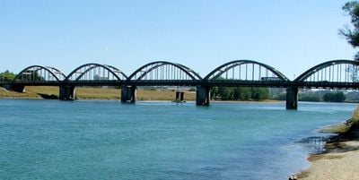
Balclutha Road Bridge, Tied-arch road bridge in Clutha District, New Zealand.

Balclutha Road Bridge is a tied-arch road bridge spanning the Clutha River with six concrete curved sections stretching about 244 meters in length. The structure carries both vehicle traffic and pedestrian paths across the river as part of the main highway corridor.

The bridge was constructed between 1933 and 1935 to replace earlier structures damaged by severe flooding and changing traffic demands. This project represented an important engineering advancement for managing major river crossings in the region at that time.

The bridge serves as a vital link across the river for the local community and travelers passing through the region. Its design reflects how engineering solutions became part of everyday life in rural New Zealand during the 20th century.

Visitors can cross the bridge on foot or by vehicle as it forms part of the main highway route through the area. Both footpaths and the roadway are accessible year-round and accommodate regular traffic flow.

The structure incorporates advanced engineering features designed specifically to withstand earthquakes and flooding, which were notable innovations for New Zealand in the 1930s. These protective design choices made it more durable than other bridges built during the same period.

The community of curious travelers

AroundUs brings together thousands of curated places, local tips, and hidden gems, enriched daily by 60,000 contributors worldwide.

Start exploring
Location
Inception
1935
Made from material
stone
GPS coordinates
-46.23592,169.74500
Latest update
December 14, 2025 09:45
« Balclutha Road Bridge - Tied-arch road bridge in Clutha District, New Zealand » is provided by Around Us (aroundus.com). Images and texts are derived from Wikimedia project under a Creative Commons license. You are allowed to copy, distribute, and modify copies of this page, under the conditions set by the license, as long as this note is clearly visible.

Discover hidden gems everywhere you go!

From secret cafés to breathtaking viewpoints, skip the crowded tourist spots and find places that match your style. Our app makes it easy with voice search, smart filtering, route optimization, and insider tips from travelers worldwide. Download now for the complete mobile experience.

Around Us App Screenshot

A unique approach to discovering new places

Le Figaro

All the places worth exploring

France Info

A tailor-made excursion in just a few clicks

20 Minutes

Around Us
Travel Guide & Maps
Download

Send to your phone

QR Code
1

Open the camera app on your mobile.

2

Point at the QR code with your camera. A notification will appear.

3

Tap the notification to open the link.