Enable Location

We need your location to show you interesting places around you

Discover nearby places

Find interesting locations and hidden gems around you

Precise directions

Get accurate directions and distances to places

Your location is never shared with other users. It's only used when you tap the location button.

Te Mata Peak

Log in to your account

Start exploring — it's free

Trusted by 62,821 travelers worldwide

Continue with Google
Continue with Apple
or

We will send you a code to connect

By continuing, you accept our Terms and Conditions and our Privacy Policy

Check your inbox

We've sent a pincode in your inbox. Please enter the code below.

Te Mata Peak

Te Mata Peak, Mountain summit in Hawke's Bay Region, New Zealand.

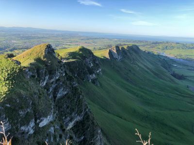
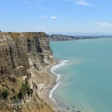
Te Mata Peak is a mountain summit in the Hawke's Bay Region standing at 399 meters, marked by steep cliffs dropping about 140 meters on its southeastern side. These dramatic faces overlook the Tukituki Valley and form the most striking feature of the landscape.

The government acquired the land from local iwi in 1850, and it was later used for farming by John Chambers before being donated to the public in 1927. This gift created today's park that anyone can freely visit.

Local Maori people see the peak's outline as their ancestor Rongokako in a resting position, linking the landscape to their creation stories and history. This connection shapes how the place is understood and respected by visitors today.

A sealed road takes visitors directly to the summit, with entry gates open from dawn until 10 PM each day. Parking areas and public toilets are available for convenient access.

The southeastern cliffs rank among the highest on New Zealand's North Island, with clear evidence of ancient rockfalls scattered across the valley floor. This geological feature draws geologists and nature watchers who study the landscape's ongoing changes.

The community of curious travelers

AroundUs brings together thousands of curated places, local tips, and hidden gems, enriched daily by 60,000 contributors worldwide.

Start exploring
Elevation above the sea
399 m
Address
Te Mata Peak Road, Tuki Tuki 4130, New Zealand
Opening Hours
Monday-Sunday 05:30-22:00
GPS coordinates
-39.70183,176.90968
Latest update
January 29, 2026 15:41
North Island in New Zealand: cities, volcanoes, Maori culture

New Zealand's North Island holds much of the country's population and has a wide variety of landscapes. This list includes 35 places that show what you can see there: cities like Auckland and Wellington, active volcanoes, geothermal areas where the ground steams and boils, black or golden beaches,...

« Te Mata Peak - Mountain summit in Hawke's Bay Region, New Zealand » is provided by Around Us (aroundus.com). Images and texts are derived from Wikimedia project under a Creative Commons license. You are allowed to copy, distribute, and modify copies of this page, under the conditions set by the license, as long as this note is clearly visible.

Discover hidden gems everywhere you go!

From secret cafés to breathtaking viewpoints, skip the crowded tourist spots and find places that match your style. Our app makes it easy with voice search, smart filtering, route optimization, and insider tips from travelers worldwide. Download now for the complete mobile experience.

Around Us App Screenshot

A unique approach to discovering new places

Le Figaro

All the places worth exploring

France Info

A tailor-made excursion in just a few clicks

20 Minutes

Around Us
Travel Guide & Maps
Download

Send to your phone

QR Code
1

Open the camera app on your mobile.

2

Point at the QR code with your camera. A notification will appear.

3

Tap the notification to open the link.